A dinosaur bone arrives in the present as an object. A fossil soil arrives as a relationship. Its colors, cracks, mineral nodules, root paths, and erased surface record a place where sediment stopped accumulating long enough for weather, water, air, and life to reorganize it.
That distinction makes a paleosol—an ancient soil incorporated into the geologic record—one of paleontology's quietest landscape fossils. It is not simply dirt found beside a fossil. Soil forms at a land surface, through interactions among rock, water, atmosphere, organisms, and time. When later sediment buries that surface, a duration of landscape activity can become part of the stratigraphic column.[2][3]
The attraction is obvious: a paleosol can put the ground back under extinct life. The danger is equally important. Soil is a layered product of several processes, then burial adds compaction, cementation, alteration, and erosion. No single red band, root-shaped tube, or chemical value can carry the whole reconstruction. Paleosols become persuasive when independent clues converge.[1][2][3]
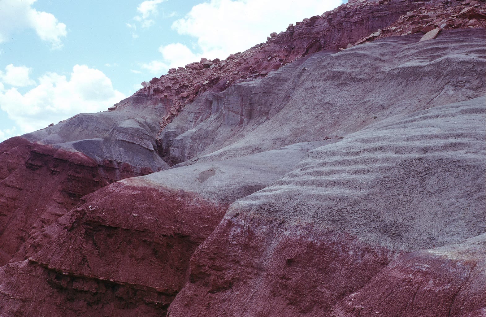
Image context: the cover is a real National Park Service field photograph of the Chinle Formation at Capitol Reef National Park in Utah. Its dark red and gray-green outcrops make the article's central problem visible: striking color invites interpretation, but color has to be tested against soil structure, horizon geometry, mineralogy, and burial history.[3][7]
A soil begins where deposition pauses
Most sedimentary layers begin with movement. A river spills mud across a floodplain. Wind lays down dust. Volcanic ash settles. A soil begins when that new material remains exposed and comparatively stable. Water moves through it; organisms churn it; roots open pathways; clays migrate; iron changes oxidation state; minerals accumulate or dissolve. The original deposit acquires a vertical organization that reflects conditions at the old surface.
This is why a paleosol can mark more than environment. It can mark missing deposition. A 1983 U.S. Geological Survey guide notes that a buried, exhumed, or relict soil may identify a hiatus and may be the only surviving record of part of that interval.[3] The layer is therefore a peculiar archive: its scientific value comes from what happened while ordinary sedimentation slowed or stopped.
It is tempting to call that layer a snapshot. It is closer to a long exposure. A footprint may preserve one step; a carcass can preserve one death. A soil combines repeated wetting and drying, generations of roots and soil animals, chemical transfers, and sometimes more than one phase of development. The resulting profile records duration without automatically supplying a precise stopwatch.
The field signature is a stack, not a color
Recognizing that duration in rock requires discipline. Orr and Roberts's 2024 field guide treats paleosol description as a structured job, proposing a 30-item field log and emphasizing fresh surfaces, horizons, color, soil aggregates called peds, mottles, mineral accumulations, organic matter, carbonate, burrows, and root traces.[1] The length of that list is itself a lesson. “Looks soil-like” is not a diagnosis.
Horizonation matters because soil processes work vertically. A surface layer may be stripped away before burial, while a subsurface horizon can retain clay coatings, blocky or prismatic peds, carbonate nodules, or mottling. Bedding inherited from the original sediment may fade as biological and chemical work overprints it. A sharp erosional top can truncate a profile that grades downward into less altered parent material.[1][3]
Color is useful, but never sovereign. Red iron oxides can indicate oxidation; gray-green tones can develop under reducing, waterlogged conditions. Yet parent material, organic matter, later groundwater, and post-burial redox reactions can also alter color. The older USGS guide makes the boundary explicit: a paleoclimate reading should rest on more than one observation because different processes can produce similar results, and diagenesis can repaint an original signal.[3]
Roots put life in the profile—and time out of alignment
Root traces are among the strongest signs that sediment once sat beneath a living land surface. They commonly taper, branch downward, and vary in direction, unlike many animal burrows, which tend to keep a more constant width. Their density, diameter, depth, halos, and mineral infill can help reconstruct vegetation and drainage even when the original plant tissue is gone.[1][3]
But a root is not a date stamp for every grain it crosses. Roots can penetrate sediment older than the surface from which they grew. Gocke and colleagues showed that root-derived pores and mineralized traces in terrestrial sediment sequences can mix chronological contexts: fine roots may enter older material, while larger rooting structures can cross several units.[5] A root trace proves biological occupation; its geometry and connection to a horizon determine which occupation it records.
That boundary prevents a common shortcut. Deep roots do not automatically mean a deep soil, a forest, or a climate identical to a modern analogue. Plant architecture has changed through evolutionary time, and erosion can remove the upper part of a profile. Paleontologists therefore have to follow roots back toward their source horizon, distinguish them from burrows and cracks, and ask whether later vegetation overprinted an older deposit.[1][5]
The Chinle colors hold a water-table story
The Chinle Formation offers a field-scale example. Across the Colorado Plateau, Late Triassic rivers deposited mud, sand, and gravel more than 200 million years ago. At Petrified Forest National Park, the National Park Service identifies colorful Chinle layers as ancient soil horizons within a largely fluvial sequence.[4]
The familiar red-versus-green contrast is not merely decorative. The park's account explains that greenish or bluish horizons developed where a high water table promoted oxygen-poor, reducing conditions, while reddish horizons formed where iron oxidized as the water table fluctuated.[4] That interpretation turns a color band into hydrology—but only because the colors sit inside mapped stratigraphy and agree with mineral and sedimentary context.
The cover photograph comes from the same formation at Capitol Reef, not from the specific Petrified Forest section described by the park guide.[7] That geographic distinction matters. “Chinle” names a vast body of rock, not one uniform soil profile. A photographed outcrop can establish real texture and setting; it cannot transfer every local interpretation across the formation without field evidence.
Climate proxies work best in company
Once a paleosol is securely identified, it can support more than a qualitative wet-or-dry label. Reviews of the field describe climate estimates built from profile morphology, weathering chemistry, clay minerals, carbonate horizons, and stable isotopes. Used carefully, these approaches can constrain precipitation, temperature, atmospheric carbon dioxide, productivity, and drainage on ancient land.[2]
The word “carefully” carries most of the weight. A carbonate nodule reflects soil water and carbon cycling, but its depth and chemistry also depend on soil development, parent material, vegetation, and seasonality. A clay mineral may have formed in the soil—or may be detritus inherited from the source sediment. An isotope value may preserve soil formation, later groundwater alteration, or some mixture of both.
A 2026 review of temperature estimates from soil-formed phyllosilicates makes those filters concrete. Researchers must separate soil-formed clays from detrital grains, identify mineral mixtures, choose appropriate fractionation relationships, and test for diagenetic alteration before translating isotopes into temperature.[6] The laboratory number is the end of an evidence chain, not an escape from field geology.
This is why the strongest paleosol studies braid scales together. Outcrop geometry shows where the profile sits. Hand-sample structure identifies peds, mottles, roots, and nodules. Microscopy and mineralogy test how those features formed. Geochemistry then asks a narrower quantitative question. Agreement among those scales is more informative than extra decimal places from one proxy.[1][2][6]
The landscape is the fossil
Paleosols change the unit of attention. A skeleton asks what an organism was. A soil profile asks what sort of ground could support organisms, how water moved through it, how long a surface persisted, and what happened before the next river deposit or ash fall buried it.
That does not make every fossil found near a paleosol an inhabitant of that exact surface. Bones can be transported, roots can overprint older sediment, and erosion can splice intervals together. Instead, the paleosol supplies a testable landscape hypothesis: a floodplain was exposed; drainage shifted; vegetation occupied the surface; soil animals burrowed; minerals accumulated; then deposition resumed. Fossils and sedimentary structures can agree with that sequence, complicate it, or show that material arrived from elsewhere.
The best reading is therefore neither “ancient dirt” nor an overconfident climate meter. A paleosol is a pause that acquired structure. Its horizons are the architecture of that pause, its roots and burrows are traces of occupation, and its chemistry is a memory that burial may have edited. Read together, those features restore something a mounted skeleton cannot: not just an extinct body, but the ground beneath its world.
Sources
- Theresa J. Orr and Eric M. Roberts, “A review and field guide for the standardized description and sampling of paleosols,” Earth-Science Reviews 253 (2024), 104788.
- Neil J. Tabor and Timothy S. Myers, “Paleosols as Indicators of Paleoenvironment and Paleoclimate,” Annual Review of Earth and Planetary Sciences 43 (2015), 333–361.
- Robert A. Miller and Wayne R. Sigleo, Parameters Related to the Identification of Paleosols in the Geologic Record, U.S. Geological Survey Open-File Report 83-776 (1983).
- National Park Service, “Geologic Formations,” Petrified Forest National Park—Chinle Formation ages, fluvial setting, soil horizons, and redox colors.
- Martina Gocke et al., “Biopores and root features as new tools for improving paleoecological understanding of terrestrial sediment-paleosol sequences,” Palaeogeography, Palaeoclimatology, Palaeoecology 394 (2014), 42–58.
- Kate Andrzejewski et al., “Estimating paleotemperature using stable isotopes of soil-formed phyllosilicates from paleosols: A review,” Earth-Science Reviews 275 (2026), 105417—USGS publication record.
- Wikimedia Commons, National Park Service photograph of red and gray-green Chinle Formation outcrop at Capitol Reef National Park—the source record for the article image.