Mistaken Point is easy to flatten into a slogan. The slogan is not wrong. UNESCO calls it a critical watershed in the history of life, and the site's own visitor material invites people to stand where "life got big."[1][2] But the stronger field reading starts one level lower, at the rock surface itself. Mistaken Point matters because it preserves ancient seafloors rather than merely yielding collectible specimens. The site keeps bedding planes, fossil spacing, orientation, and burial relationships visible enough that paleontologists can still ask community-scale questions about organisms that lived roughly 580 to 560 million years ago.[1][4][5]
That is why the place still feels scientifically alive in 2026. UNESCO's listing page is explicit about the scale: Mistaken Point is a 17-kilometre strip of rugged coastal cliffs with a deep-marine rock sequence, more than 10,000 visible fossil impressions, and over 100 exposed sea-floor surfaces, some carrying up to 4,500 megafossils.[1] Those numbers matter because they force a shift in method. This is not a locality where one famous slab or one charismatic body plan does all the interpretive work. It is a locality where the surface itself becomes data.
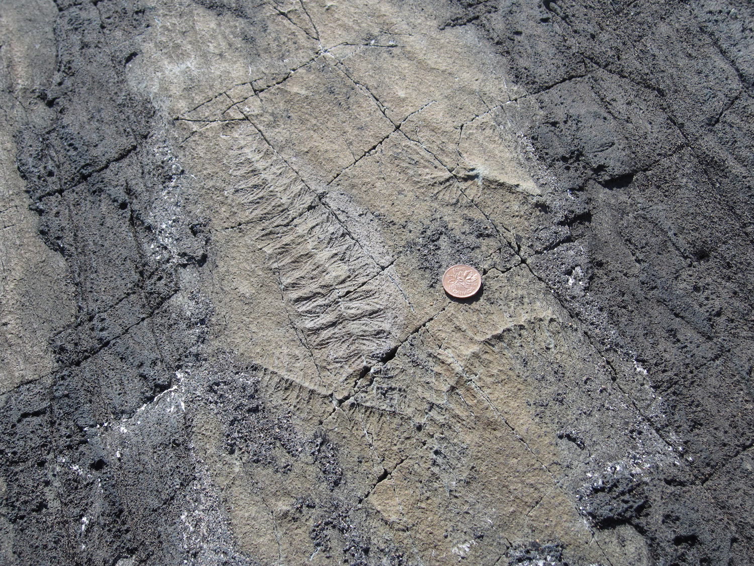
Image context: the cover uses a real Wikimedia Commons photograph of fossils exposed on a Mistaken Point bedding plane.[6] It belongs here because the article's main claim depends on staying at outcrop scale. The coin, the flat rock, and the distributed impressions all keep attention on community layout and life position rather than on one cleaned museum specimen.
The site is a preserved seafloor before it is a fossil gallery
UNESCO's description gives the best opening frame because it keeps the geology and the paleobiology locked together.[1] Mistaken Point is not simply old. It is deep-marine in origin, and its fossil-bearing surfaces are exposed along naturally eroding coastal cliffs rather than being extracted into a conventional hall of masterpieces.[1] The official site makes the same point more gently for visitors: these fossils provide access to organisms that lived over 565 million years ago during the Ediacaran, and seeing them means going to the surfaces themselves.[2]
That distinction matters because a fossil locality can teach different things depending on how much context survives. A museum mount can clarify anatomy. A preserved bedding plane can also show whether organisms overlap, whether one taxon clusters with another, whether the bodies share a common orientation, and whether the assemblage looks transported or remains close to where the organisms actually lived. Mistaken Point is unusually strong because it preserves those questions in place.[1][4]
UNESCO's language on this is unusually crisp. The page states that the animals died where they lived and that the resulting assemblages preserve not only morphology but also the ecological structure of their communities.[1] That is the heart of the field report. Mistaken Point is not primarily a taxon list. It is one of the rare localities where ecology survives on the same slab as form.
The ash beds matter because they preserved life position instead of reducing everything to drift
The most famous phrase attached to Mistaken Point is probably UNESCO's "Ediacaran Pompeii."[1] It is vivid, but it is useful only if handled carefully. The value of the comparison is not disaster drama for its own sake. The value is that repeated influxes of volcanic ash buried soft-bodied organisms quickly enough to preserve fine impressions on the sea floor.[1] Fast burial is what allowed a community of large, delicate, pre-Cambrian organisms to remain legible instead of dissolving into a generic deep-time blur.
That does not mean every fossil on every surface stood upright in the water column at the moment the ash arrived. One of the ongoing Mistaken Point debates turns precisely on life attitude and orientation. The official fossil guide notes that the random orientations of Fractofusus on bedding planes are one reason researchers infer that it reclined on the seafloor rather than standing erect in the water column.[2] The 2022 Frontiers paper pushes the locality-wide argument further. Its abstract treats the E Surface assemblage as an obruption deposit that smothered biomass and necromass in life position, probably through ash-fall rather than through a turbidity current that mechanically felled every frond in one preferred direction.[3]
That shift in emphasis is important because it changes what the reader is allowed to infer from the rock. If the surface were simply a transport sheet, then orientation and spacing would mostly tell us about current energy after death. If the surface is closer to an in-place smothered community, those same patterns carry ecological meaning as well.[1][3][4] Mistaken Point remains valuable precisely because the debate has become more disciplined, not because it has vanished. The locality rewards caution while still preserving enough structure to keep the question open.
Mistaken Point works best when read as a community, not as a parade of strange fronds
The official site now introduces visitors to familiar names such as Fractofusus, Charniodiscus, Thectardis, and Beothukis.[2] That is sensible for interpretation, but the deeper scientific payoff comes from reading those organisms together on surfaces rather than one by one in isolation. Mitchell and colleagues' 2019 Ecology Letters paper explains why. The authors mapped seven Ediacaran paleocommunities, including multiple Mistaken Point surfaces, using LiDAR, photogrammetry, and laser-line scanning, and they argued that these bedding planes can be treated as near-complete census paleocommunities rather than as badly incomplete scraps.[4]
That claim is one of the most consequential things a field reader can carry away from the site. A census-like surface changes the scale of paleontology. Instead of asking only what one organism looked like, researchers can ask how many individuals occupied a patch, how they were distributed, and whether the spatial structure looks driven by strong niche partitioning or by weaker, more neutral processes.[4] Mitchell and colleagues concluded that neutral processes dominated these early communities, with niche processes exerting only limited influence.[4]
The point is not to force a modern ecological theory contest onto an Ediacaran outcrop for sport. The point is that Mistaken Point keeps enough community geometry intact that such tests are even possible. That is rare. Most fossil localities destroy the original neighborhood before the scientist arrives. Mistaken Point still lets researchers read the neighborhood.
Height and stems did not simply mean a race for food higher in the water column
This is where the site gets more interesting than the usual "first big organisms" summary. One intuitive story about Ediacaran fronds is that stems and height must reflect competition for suspended resources higher above the seafloor. The 2018 Nature Ecology & Evolution paper by Mitchell and Kenchington used spatial analyses from Mistaken Point to test that idea directly.[5] Their finding was not the expected one. They reported no correlation between tiering and resource competition, and argued instead that height correlated more strongly with offspring dispersal than with a simple feeding race upward.[5]
That result belongs in a field report because it shows how locality-scale preservation can overturn a too-neat adaptation story. At Mistaken Point, a stem does not automatically mean "better feeding position." It may instead reflect the ability to spread propagules farther across the surface.[5] Once again the bedding plane matters more than the silhouette. The fossils do not just preserve strange bodies. They preserve the spatial evidence needed to ask what those bodies were for.
Put together, these studies keep Mistaken Point from collapsing into a shrine of firstness. Yes, the locality documents a very early moment in the history of large, complex life.[1] But its scientific force lies in something more exact: ash beds preserved deep-sea communities broadly in place, and those surfaces still allow arguments about life position, dispersal, clustering, and community structure to be tested against the rock itself.[1][3][4][5]
That is why the best way to visit Mistaken Point is to think like a field paleontologist before thinking like a pilgrim. The famous fossils are real, the age is extraordinary, and the site does deserve its landmark status.[1][2] But the locality becomes most legible when the reader slows down and stops treating each impression as a standalone emblem. Mistaken Point is a bedding plane first. The ash, the surface, the spacing, and the fact that the organisms largely stayed where they lived are what turn it from a spectacular stop into one of paleontology's cleanest surviving community experiments.
Sources
- UNESCO World Heritage Centre, "Mistaken Point" - official site description covering the 17-kilometre coastal strip, 580-560 million-year age range, more than 10,000 visible impressions, more than 100 exposed sea-floor surfaces, and the ash-burial "Ediacaran Pompeii" framing.
- Mistaken Point | Newfoundland, "The Fossils" - official visitor-facing page describing the Ediacaran fossils, guided viewing context, and organism-specific notes including the seafloor-reclining interpretation for Fractofusus.
- D. McIlroy, D. Perez-Pinedo, G. Pasinetti, C. McKean, R. S. Taylor, and R. N. Hiscott, "Rheotropic Epifaunal Growth, Not Felling by Density Currents, Is Responsible for Many Ediacaran Fossil Orientations at Mistaken Point," Frontiers in Earth Science 10 (2022).
- Emily G. Mitchell and colleagues, "The importance of neutral over niche processes in structuring Ediacaran early animal communities," Ecology Letters 22, no. 12 (2019).
- Emily G. Mitchell and Charlotte G. Kenchington, "The utility of height for the Ediacaran organisms of Mistaken Point," Nature Ecology & Evolution 2 (2018).
- Wikimedia Commons file page for the Mistaken Point bedding-plane photograph used as the article image: "Ediacaran fossils Mistaken Point Newfoundland.jpg."