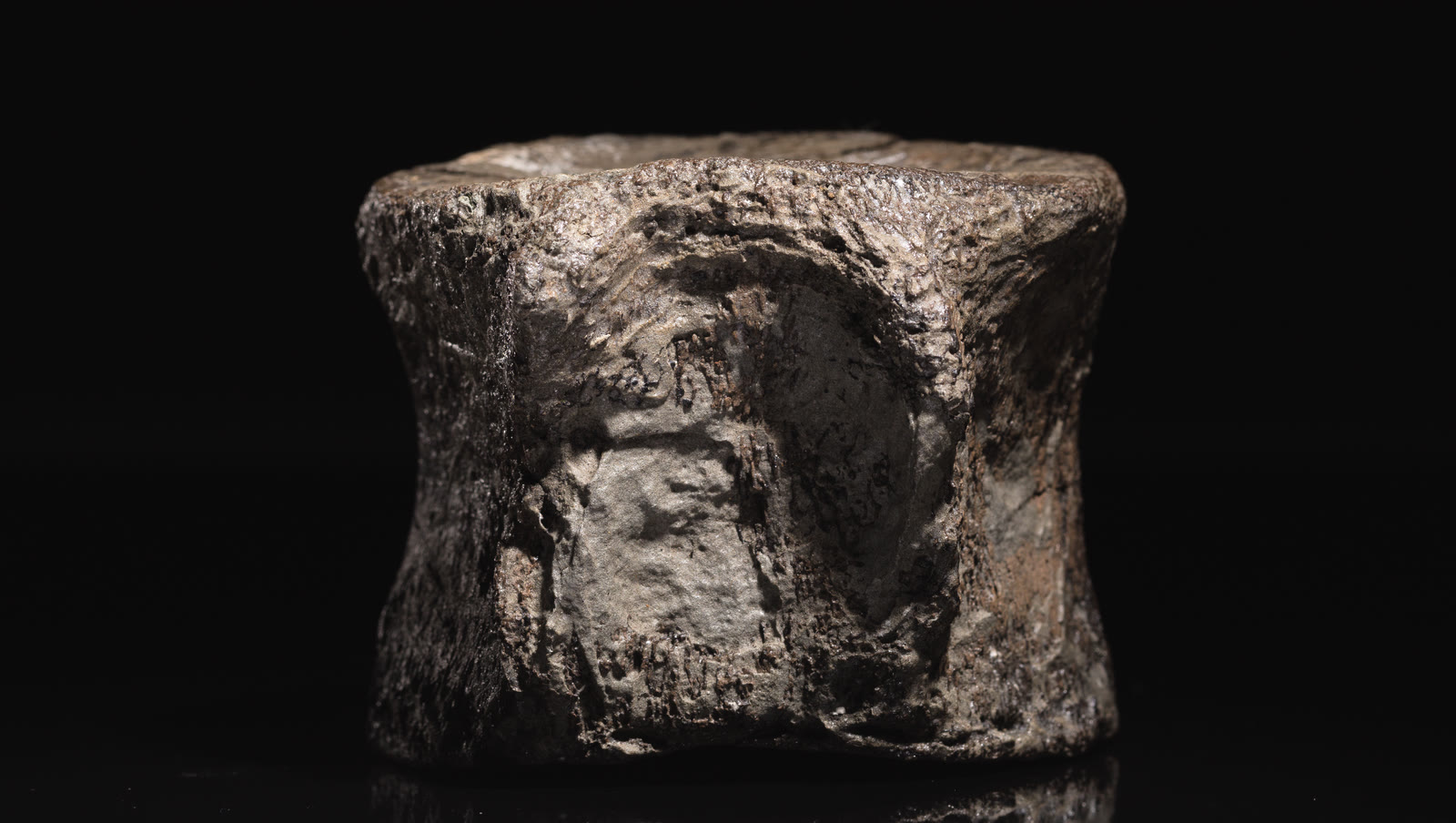

The photograph above is Auckland Museum specimen LH1514, a genuine plesiosaur vertebral centrum from the Mangahouanga fossil locality; it is a comparison, not one of the specific finds shown in the film.[6][7] Its published catalogue stops at Plesiosauria indeterminate rather than forcing a family or genus. Seen end-on against black, the single bone makes the film’s field problem tangible: a vertebra can be recognizable before it can be assigned to a narrower group. That separation between observation and identification is the right way into Mangahouanga Stream.
Reptile Fossils from an Unexplored Valley, released by GNS Science in 2012 (the institute is now Earth Sciences New Zealand), initially looks like an expedition story: a team crosses difficult country and finds large reptile vertebrae. Most of its new field sequence follows Wiffen Stream, a remote tributary within the wider Mangahouanga catchment, rather than the main stream.[3] Watched more closely, the film is about how a fossil locality edits itself. Forest and gorge restrict where people can look. Flowing water exposes Late Cretaceous rock, shifts loose blocks, and sometimes separates a fossil from the bed in which it formed. A hard concretion can preserve bone while making it difficult to see or remove.[1][3]
The useful question, then, is not simply “What did they find?” It is “What sequence of filters made this particular find available?” Keep three places distinct while watching: the ancient environment where an animal’s remains entered sediment, the rock exposure where that sediment survives, and the point in the present stream where a movable fossil-bearing boulder happens to be encountered.
The viewing
0:00–1:24: access is a sampling filter
The opening minute spends its time on distance, vines, steep forest, deep pools, waterfalls, and narrow gorges. The party carries inner tubes so it can float parts of the watercourse. These are not decorative adventure shots. They explain the boundaries of the search. Julian Thomson’s first-hand account identifies the tributary as Wiffen Stream and describes it as screened by private forestry land, a high waterfall, and a densely forested ridge; even after entering it, the group had to negotiate log jams and drops in the stream.[1][3]
That difficulty creates a bias worth naming. A map may show continuous fossil-bearing rock, but the inspected sample is concentrated where a person can safely reach, pause, and recognize an exposed surface. The film’s “unexplored” valley is therefore not a sealed geological chamber. It is a section that had received little direct human observation because the route into it was unusually costly.
The access sequence should not be mistaken for a route guide. Thomson says the approach crosses privately owned forestry land and that the field party coordinated with the forest manager.[3] The film documents a research expedition; it does not grant permission to enter the catchment or collect fossils there.
Pause when the camera looks along the water rather than at a specimen. The stream is both route and geological agent. It strips some surfaces clean enough to inspect, covers others with sediment or vegetation, and rolls blocks away from their original positions. A fossil found loose in the channel is real evidence, but its recovery point is not automatically its place of deposition. The landscape determines what becomes visible before a palaeontologist makes any identification.
Around 1:40: land bones arrive already edited
The middle of the film turns back to finds associated with Joan Wiffen’s decades of work in the valley: a mosasaur lower jaw, a pterosaur bone, and a worn dinosaur vertebra identified in the narration as titanosaurian. The film’s reconstruction has the vertebra travel down a river and out to sea before burial. Whether every step can be recovered in detail or not, the contrast is essential: mosasaurs and plesiosaurs inhabited the marine system represented by the local rocks, while a dinosaur bone had to cross environments before joining that archive.[1]
Wear and transport are not just damage that happened before discovery; they are information. A rounded, isolated terrestrial bone in marine sediment answers a different question from an articulated skeleton preserved where an animal lived. It can establish that a dinosaur existed in the wider landscape without providing a census of that landscape or a precise map of its habitat.
The Science Learning Hub timeline gives the sequence behind the montage. Joan and Pont Wiffen first visited Mangahouanga in 1972. Finds in the following years included plesiosaur material, a mosasaur skull, and dinosaur remains that helped overturn the assumption that New Zealand had no dinosaur record.[2] The narration goes further and calls the valley’s dinosaur bones the country’s only examples. That was already too broad when the video appeared: the timeline records dinosaur material at Port Waikato in 1995 and on the Chatham Islands in 2003. This is not a reason to discard the film; it is a reason to annotate it. An expedition video can preserve an obsolete claim alongside irreplaceable observations.[1][2]
After 3:10: a concretion protects and conceals
In the final stretch, the party reaches sections beyond the area previously searched by Wiffen’s group. One boulder contains a row of large marine-reptile vertebrae. Another nearly spherical concretion has split across a vertebral element, exposing enough shape to recognize bone but not enough to give the animal a confident name. The researchers say they will investigate rather than manufacture a field identification.[1]
That restraint is the most important moment in the film. Concretions are unusually hard masses cemented within sedimentary rock. At Mangahouanga, they can carry reptile bones, and the same hardness makes extraction difficult. Thomson records that most specimens seen during the earlier visit remained in place; one unidentified bone could neither be diagnosed nor removed from its concretion in the field.[3]
Watch the fracture line. A lucky split makes the fossil visible, but splitting is not a neutral viewing technology: the break can pass through the bone itself. Recognition, recovery, preparation, and identification are four separate stages. The closing shot supplies a promising observation, not the final word on the specimen.
The 2023 sequel: a cyclone changes the exposure
The film was published in 2012, but the locality did not stop moving. After Cyclone Gabrielle struck Hawke’s Bay in February 2023, GNS Science (now Earth Sciences New Zealand) reported that floodwater had scoured the Mangahouanga streambed and overturned boulders. A late-March storm-damage assessment outing found newly exposed vertebrae, with possible elasmosaur and mosasaur material treated provisionally while examination continued.[4]
This is not a simple story in which erosion helps fossil hunters. The same energy that reveals a surface can abrade it, shift it downstream, or erase its relationship to nearby layers. The post-cyclone discoveries therefore sharpen the lesson already latent in the video: a fossil-bearing stream is a changing exposure, not an open-air storage drawer. A visit documents one state of the locality. It does not exhaust it.
The contrast also explains why a field film has value beyond the objects carried home. Its views of water level, boulder position, vegetation, and access supply a qualitative visual baseline. This is not a fixed-camera repeat survey, so the footage cannot prove whether an individual boulder was newly exposed or merely moved into view. It does preserve one earlier state of a landscape that a later storm rearranged.
A loose fossil still needs an address
New Zealand’s Fossil Record File is built around context as well as identity. Its records can include locality, collection details, stratigraphic position, rock type, age, identification, and interpreted environment.[5] Those fields explain why “marine reptile vertebra from Mangahouanga” is a beginning rather than a complete record.
For a fossil found in a loose stream boulder, the practical address should preserve what remains knowable: the exact recovery point, photographs before movement, the character of the block, nearby exposures, and the reasoning used to connect it with a rock unit. Later preparation may change the anatomical identification; later mapping may refine the geological one. Neither improvement can reconstruct field context that was never recorded.
Seen this way, the film’s inner tubes, waterfalls, rolled boulders, and stubborn concretions are not obstacles around the science. They are part of the evidence. Mangahouanga teaches palaeontology at the scale of a whole valley: ancient transport carried at least some terrestrial remains into a marine archive where marine reptiles were also buried; cementation made some remains resistant; modern streams released and rearranged their containers; human access selected what could be observed; and records must hold those stages together after a specimen leaves the water.
Sources
- GNS Science (now Earth Sciences New Zealand), “Reptile Fossils from an Unexplored Valley,” field video published January 23, 2012, YouTube.
- Science Learning Hub, “Joan Wiffen – paleontologist,” timeline of the Mangahouanga fieldwork and subsequent New Zealand discoveries.
- Julian Thomson, “Reptile Fossils from an Unexplored Valley,” first-hand account of access, concretions, finds, and specimens left in place, Out There Learning, January 2012.
- GNS Science (now Earth Sciences New Zealand), “Cyclone Gabrielle uncovers new secrets set in stone,” report on post-cyclone changes and fossil finds at Mangahouanga Stream.
- Earth Sciences New Zealand, “New Zealand Fossil Record File,” description of the national locality and collection database and its recorded fields.
- Auckland Museum Collections, “Chordata vertebrata reptilia plesiosauria plesiosauridae” (specimen LH1514), photograph by Andrew Hales, 2018, Wikimedia Commons. Licensed CC BY 2.0.
- Brian J. Gill and Michael K. Eagle, “New Zealand Mesozoic marine reptiles in the Auckland Museum collection,” Records of the Auckland Museum 49 (2014), catalogue record; the paper lists LH1514 as a Mangahouanga plesiosaur vertebral centrum.