
Oxford University Museum of Natural History's The Jurassic Highway is nominally a public talk about a sensational 2024 quarry discovery in Oxfordshire. But the lecture is most useful when watched against the grain of the headline.[1] The phrase "dinosaur highway" invites the wrong mental picture: a parade of giant feet, a row of impressive casts, a piece of Jurassic spectacle scaled for television. The researchers on stage keep pulling the audience somewhere more interesting. They repeatedly turn attention back to the floor itself: how long it was exposed, how it was recorded, what else lay in it besides tracks, and how the trackways connect with older Oxfordshire discoveries at Ardley.[1][2][3][4]
That is what makes the video worth embedding in 2026. The Dewars Farm site matters because it preserves a short-lived surface rather than a pile of disconnected objects.[2][3] Oxford's public summary and press release frame the discovery in exactly those terms: roughly 200 footprints, at least five separate trackways, a Middle Jurassic age of around 166 million years, and a longest continuous trackway of more than 150 metres.[2][3] Those numbers are exciting, but the lecture adds the methodological weight that a press cycle usually drops. A tracksite is not just evidence that dinosaurs existed in a place. It is evidence that several bodies crossed a particular substrate, in a particular order, during a narrow interval of surface life before burial sealed the scene shut.[1][3]
That distinction is why trackways can feel unusually alive compared with many body fossils. Bones often arrive after transport, breakage, and anatomical sorting. Trackways begin with contact. A foot presses into wet sediment, displaces the margin, interrupts burrows, and sometimes traps or distorts traces of smaller organisms already present on the surface.[1] The Oxford panel makes this point better than the "highway" metaphor does. What they recovered is not merely a dinosaur route; it is a preserved traffic surface from a lagoonal mudflat environment, one that can still be mined for sequence, substrate, and behavior.[1][2][5]
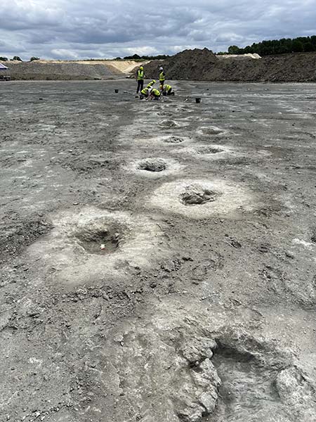
Image context: the cover uses an Oxford photograph of the excavated trackway surface leading into the distance. It belongs here because this article argues against treating any single print as the whole story. The image works by showing continuity: one footprint after another, preserved as a line across the quarry floor, with direction and spacing still readable at a glance.[2]
Around 0:20 to 2:45, the lecture resets the discovery from TV spectacle to excavation system
The host opens by acknowledging the BBC segment that brought much of the audience into the room, then immediately says that the television piece covered only a fraction of the actual work.[1] That small framing move matters. Instead of starting from dinosaur celebrity, the lecture starts from excavation organization: who ran the dig, which institutions collaborated, how quarry operators and volunteers made the exposure usable, and why so many hands were needed before any scientific claim could stabilize.[1][3]
The press release gives the hard scale behind that opening: a week-long excavation in June 2024, a team of more than 100 people, and a quarry floor so extensive that recording it was as important as uncovering it.[3] In the talk, the thank-you list is long enough to make the point on its own: quarry staff, museum staff, university researchers, volunteers, press teams, and the worker who first noticed the regular bumps in the clay.[1] Paleontology enters here as organized response to a temporary opportunity. Once the quarry floor is open, the clock starts ticking.
That is the first reason the video is worth watching. It teaches that a famous site is often born out of an industrial landscape and a narrow preservation window. The quarry is not an inconvenient backdrop to the "real" paleontology. It is the condition that exposed the surface and also the reason the surface cannot simply be admired forever in place. A tracksite like Dewars Farm has to be documented while it is available, then translated into records durable enough to outlast the exposure.[1][2][3]
Around 7:45 to 12:35, the real star is the recording pipeline
The most revealing stretch of the lecture arrives when the panel turns from publicity images to recording method.[1] They describe drone-based photography, 3D models, hand-shot image series, and a workflow in which volunteers took roughly 60 photographs per individual footprint so the entire site could be rebuilt digitally.[1] By the time the speaker says that about 20,000 photographs were taken over the course of the week, the discovery stops sounding like a row of footprints and starts sounding like a data-conservation exercise.[1][3]
The lecture's phrase "digital cast" is especially useful.[1] It captures what a temporary tracksite needs from modern paleontology. You cannot hold an entire quarry floor in a museum drawer. What you can do is convert it into dense visual records, photogrammetric models, and false-color depth renderings that preserve shape, spacing, and relief after the physical exposure changes.[1][3] The site becomes reusable because it has been turned into a layered record, not because every footprint has been cut out and moved.
Just as important, the panel insists that the surface contains more than tracks. Once the cut blocks were cleaned, the quarry floor turned out to be crowded with shell fragments, burrows, smaller organisms, and sedimentary textures that help reconstruct the environment the dinosaurs actually crossed.[1] That is exactly the right paleontological lesson to draw from the video. A footprint is never only foot anatomy. It is a stress test applied to a living substrate. When the sediment is good enough, the track records what was already there and how that preexisting surface reacted under load. The Oxford speakers even note cases where dinosaur feet displaced and distorted burrows below them, which makes the tracksite valuable not just for identifying dinosaurs but for recovering a richer picture of the mudflat they were moving across.[1][2]
Around 12:25 to 15:00, the lecture ties tracks to environment before it ties them to names
One of the best moments comes when the panel reaches for a modern analog and imagines something like broad carbonate mudflats and lagoons, "maybe the Florida Keys," as a way to picture Jurassic Oxfordshire.[1] The comparison is not there to make the ancient world feel cute or picturesque. It clarifies scale and depositional setting. The Oxford summary likewise describes dinosaurs walking across mudflats bordered by warm tropical lagoons, with rapid flooding and clay-rich sediment then helping preserve the impressions.[2]
That environmental frame matters because the temptation with a famous theropod print is always to jump straight to the name on the label. The panel does address identity, and later in the talk it argues that time and place make Megalosaurus the best fit for the three-toed theropod tracks, while large sauropod trackways likely point toward Cetiosaurus or closely related animals in the Oxfordshire record.[1][2][4] But the lecture is strongest when it delays that move. It first teaches the audience to read the trackway as a surface event. Only then does it narrow the trackmakers.
That sequence is defensible because Oxfordshire already has a deep local trackway record. The classic Ardley Quarry site discovered in 1997 produced extensive theropod and sauropod trackways, and Day and colleagues showed just how much information a large Oxfordshire tracksite could hold once long trackways were mapped as systems rather than as isolated prints.[4] Dewars Farm enlarges that tradition. It does not replace the older site; it reconnects to it. The lecture repeatedly treats the new discovery as part of a county-scale archive of movement surfaces.[1][4]
Around 46:00 to 47:55, the panel is careful about behavior, and that caution is the whole point
The audience question on whether the sauropod trackways imply herd behavior produces the most mature exchange in the video.[1] No one tries to sell certainty too cheaply. The speakers point back to the earlier Ardley site, where numerous broadly parallel trackways supported long-standing expectations about group behavior among sauropods, potentially including differently sized individuals.[1][4] But they also mark the limits: preservation varies, foot anatomy can converge, and a single exposed slice may capture only part of a bigger traffic pattern.[1]
That caution is not a weakness in the lecture. It is the lecture's strongest scientific virtue. Trackways are unusually vivid evidence, which means they tempt over-reading. A crossing surface can suggest synchrony, directionality, or repeated movement through the same corridor, but it rarely gives us a full behavioral script.[1][5] The Oxford panel handles this well. It allows the audience to see why the site could preserve close timing and possible grouping while still refusing to claim more than the tracks can actually bear.
That is also where the "traffic map" metaphor becomes more accurate than the "highway" metaphor. Highways imply purpose, destination, and perhaps even stable routes repeated over long spans. Traffic maps are humbler and closer to the evidence. They show movement traces on a living surface. They show crossings, spacing, direction, overlap, and density. They can imply congestion or coordination, but only within limits. The Oxfordshire trackways are powerful because they preserve exactly that sort of bounded, surface-based information.[1][2][4][5]
The result is a better way to understand why this discovery matters. The Dewars Farm quarry floor is not just another stage for a famous dinosaur name. It is a temporary Middle Jurassic surface that was captured before it disappeared back into quarry time. The lecture earns attention because it explains how that capture happened and what kind of evidence it produced: long trackways, digitally retained relief, substrate deformation, environmental context, and a cautious bridge from footprint geometry to animal behavior.[1][2][3][4] If you watch it that way, the Oxford dinosaur highway stops being a Jurassic postcard and becomes something rarer: a lesson in how paleontology reads movement, not just bodies.
Sources
- Oxford University Museum of Natural History, "The Jurassic Highway," YouTube video, published February 18, 2025.
- Oxford University Museum of Natural History, "Uncovering Oxfordshire's 'dinosaur highway'" - museum overview of the Dewars Farm trackway discovery, environment, and fieldwork.
- Oxford University Museum of Natural History and University of Birmingham, "Major new footprint discoveries on Britain's 'dinosaur highway'" - press release PDF with discovery metrics, excavation details, and trackway lengths.
- J. J. Day, D. B. Norman, A. S. Gale, P. Upchurch, and H. P. Powell, "A Middle Jurassic dinosaur trackway site from Oxfordshire, UK," Palaeontology 47(2) (2004).
- N. L. Razzolini et al., "Ichnological evidence of Megalosaurid Dinosaurs Crossing Middle Jurassic Tidal Flats," Scientific Reports 6, 31494 (2016).