As of 2026-07-03 08:32 UTC (18:32 ChST in Guam and the Northern Mariana Islands), Typhoon Bavi has moved from watchful forecast language into a readiness clock for the Marianas. The key change is not simply that Bavi exists east of Guam. It is that official products now line up around rapid intensification, deteriorating conditions beginning before the closest approach, and a recovery backdrop still shaped by Super Typhoon Sinlaku in April.[1][2][4]
The practical takeaway is narrow: households, ports, shelters, utilities, hospitals, and base operations should treat the next day as a lock-in period, not as ordinary pre-storm monitoring. Forecast tracks can still move, and the worst island-by-island impacts remain uncertain. But the timing window is no longer generous.[2][3][4][5]
Uncertainty boundary: this report uses official products available by the timestamp above. Tropical-cyclone intensity, track, rain totals, and coastal flooding can change quickly; follow NWS Guam and local emergency officials for live instructions.
Fact line
| Timestamp | Source | Key claim | Confidence note |
|---|---|---|---|
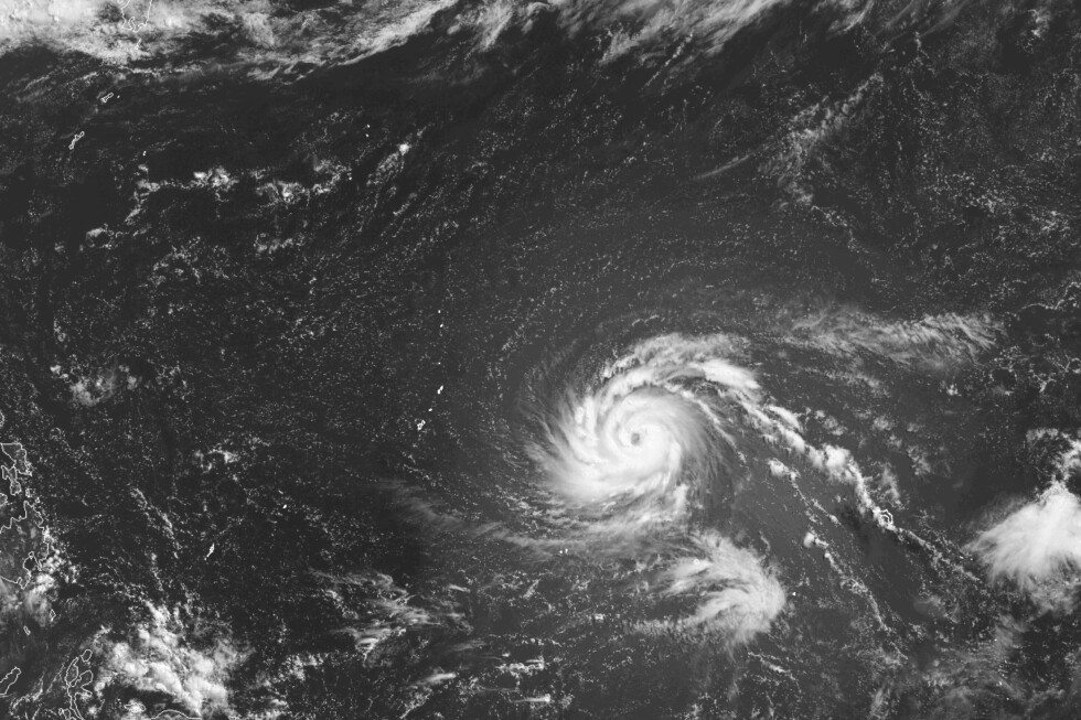
| 2026-07-03 01:56 UTC | NWS Guam Tropical Weather Discussion | Bavi had strengthened to a typhoon with sustained winds near 105 mph, was roughly 605 miles east of Guam, and was forecast to pass the Marianas as at least a high-end Category 4 super typhoon, with a Category 5 possibility.[2] | High for current analysis at issuance; exact track and peak intensity remain forecast-sensitive. |
| 2026-07-03 01:52 UTC | NWS Guam Special Weather Statement | Typhoon conditions were possible late in the weekend into early next week; Bavi was expected to arrive around Sunday night into Monday morning, with 6 to 12 inches of rain and seas building sharply.[3] | High for readiness planning; NWS explicitly warned that no island could yet be ruled out from direct impacts. |
| 2026-07-03 03:00 UTC | JTWC Warning No. 009 via NOAA | JTWC placed Bavi near 12.7N, 155.3E with 90-knot one-minute sustained winds and forecast 150-knot peak intensity by July 5.[5] | High for DoD tropical-cyclone guidance; wind definitions differ from some civilian products. |
| 2026-07-03 04:13-07:48 UTC | NWS watches and advisories | Flood, coastal-flood, and typhoon-watch language pointed to 6 to 12 inches of rain, locally higher totals, possible inundation near the eyewall, and marine conditions dangerous even for larger vessels.[4] | High for hazard categories; inundation and rainfall depend on where the core crosses. |
| 2026-07-03 | AP reporting | Guam and the CNMI are preparing while parts of the region are still recovering from Sinlaku, including lingering power and housing disruptions.[1] | Credible field context; not a substitute for official hazard instructions. |
What changed in the file
The most important shift is sequencing. A weak or slow-moving tropical system can leave emergency managers with several cycles of wait-and-see time. Bavi is different because official products are describing rapid intensification at the same moment they are shortening the public preparation window. NWS Guam said outer rain bands could begin affecting the Marianas on Saturday night, before the expected closest approach on Monday morning.[2]
That means the useful decision horizon is earlier than the centerline on the track map. If heavy rain, rough seas, and surf begin before the eyewall question is settled, the region has to complete many physical tasks while conditions are still workable: plywood, generators, prescriptions, shelter transport, fuel, vessel movement, drainage clearing, and communications checks. The forecast does not need to be perfect for those jobs to become time-critical.[3][4]
The second change is that Bavi is arriving into a damaged system. AP's report from Honolulu emphasized that Guam and the Northern Mariana Islands are bracing only months after Sinlaku, with full recovery still incomplete in parts of the CNMI.[1] That context matters because storm vulnerability is not determined only by peak wind. It is also determined by whether roofs, utilities, roads, cash reserves, crews, and temporary housing have had time to reset.
The third change is the spread of hazards. Wind is the headline because Bavi may become a super typhoon. But NWS watches also move the file into flooding and coastal-inundation territory: 6 to 12 inches of rain, locally higher totals, saturated soils, possible mudslides, surf and coastal flooding, and catastrophic marine conditions for small craft.[3][4] For a chain of islands, that converts the storm from a single wind event into an access, shelter, harbor, and recovery logistics problem.
Who should care in the next 24 hours
Residents in Guam, Rota, Tinian, and Saipan should care because the preparation task list is now more important than the exact landfall dot. NWS warned that forecast-track adjustments would continue and that no island could be ruled out from direct impacts.[3] Waiting for track certainty is the wrong threshold when rain, surf, wind, and power risk can begin before the center arrives.
Mariners and port operators should care because the marine language is already severe. NWS described a typhoon watch for Marianas coastal waters and warned of winds, very high seas, and unsafe conditions for vessels as Bavi approaches.[4] The operational issue is not whether a boat can ride out ordinary weather. It is whether it can be secured, moved, or kept in safe harbor before the weather removes those options.
Health systems, shelters, and utilities should care because Bavi is likely to stress the same last-mile systems that determine survival after the wind passes. Power continuity, dialysis and oxygen needs, fuel, backup communications, debris clearance, and shelter capacity all become harder once roads flood or winds make movement unsafe. Sinlaku's unfinished recovery raises the cost of treating Bavi as a normal seasonal typhoon.[1]
Emergency managers outside the islands should care because the public story can lag the hazard. A satellite image and a forecast cone can make Bavi look like a future event. For local logistics, it is already present: crews are deciding what can be finished before Saturday night rain bands and what must wait until after the storm.[2][4]
Scenarios
Base case: Bavi continues strengthening and passes close enough to the Marianas to bring dangerous winds, heavy rain, coastal flooding, and major marine hazards. In this branch, the worst impacts concentrate near the core, but all islands see meaningful disruption. The trigger to watch is whether successive NWS and JTWC cycles keep the center close to Guam-Rota-Tinian-Saipan and maintain rapid-intensification guidance.[2][4][5]
Upside case: The track shifts enough that the eyewall misses the most vulnerable islands, or intensification peaks below the highest guidance. This would reduce the catastrophic-wind risk, but it would not erase the need to prepare for flood, surf, outages, and harbor restrictions. The trigger is a sustained multi-cycle shift away from the islands plus lower wind guidance, not one model run.[3][5]
Downside case: Bavi reaches Category 5 strength near the islands and the eyewall crosses one of the population or infrastructure centers. In that branch, the rain and coastal hazards stack on top of destructive wind, and Sinlaku's lingering recovery damage becomes part of the impact pathway. The trigger is convergence between JTWC peak-intensity guidance, NWS local watches or warnings, and a track placing the core near Guam, Rota, Tinian, or Saipan.[1][4][5]
Action checklist
- Treat July 3-4 ChST as the household preparation window: secure shutters or plywood, water, medications, infant and elder-care supplies, pet needs, cash, chargers, documents, and offline contacts.
- Do not wait for perfect track certainty. The invalidation condition is a clear official downgrade or sustained track shift, not a social-media model image.
- Move vessels and marine equipment toward safe harbor now; NWS explicitly warns of severe marine hazards as Bavi approaches.[4]
- If you are in a low-lying, flood-prone, or coastal-inundation area, plan the shelter or relocation decision before rain bands make road movement harder.
- Clear drains and move property away from streams only while it is safe to do so; stop exterior work when local officials or conditions say the window has closed.
- Follow NWS Guam, Guam/CNMI emergency management, and official base or port instructions over generalized storm commentary.
Bottom line
Bavi's news value is not just that another typhoon is approaching the western Pacific. The reportable change is that the readiness clock has compressed while the hazard envelope has widened. NWS Guam is already flagging wind, rain, surf, coastal flooding, and marine danger; JTWC is forecasting super-typhoon intensity; AP's field reporting shows the region is not starting from a fully recovered baseline after Sinlaku.[1][2][4][5]
For the Marianas, the right question is no longer "where will the center be on Monday?" The better question is "what must be finished before Saturday night makes preparation harder?"
Sources
- Jennifer Sinco Kelleher, "Possible super typhoon threatens US Pacific territories still recovering from last storm." Associated Press, July 3, 2026.
- National Weather Service Tiyan, Guam, "Tropical Weather Discussion" for the western North Pacific, issued 2026-07-03 11:56 ChST.
- National Weather Service Tiyan, Guam, "Special Weather Statement: Typhoon conditions possible late this weekend through early next week as Typhoon Bavi approaches the Mariana Islands," issued 2026-07-03 11:52 ChST.
- National Weather Service, "Watches, Warnings & Advisories" for Guam and the Mariana Islands, including typhoon, flood, and coastal-flood watch language on July 3, 2026.
- Joint Typhoon Warning Center, "Typhoon 09W (Bavi) Warning No. 009," distributed via NOAA TGFTP, July 3, 2026.