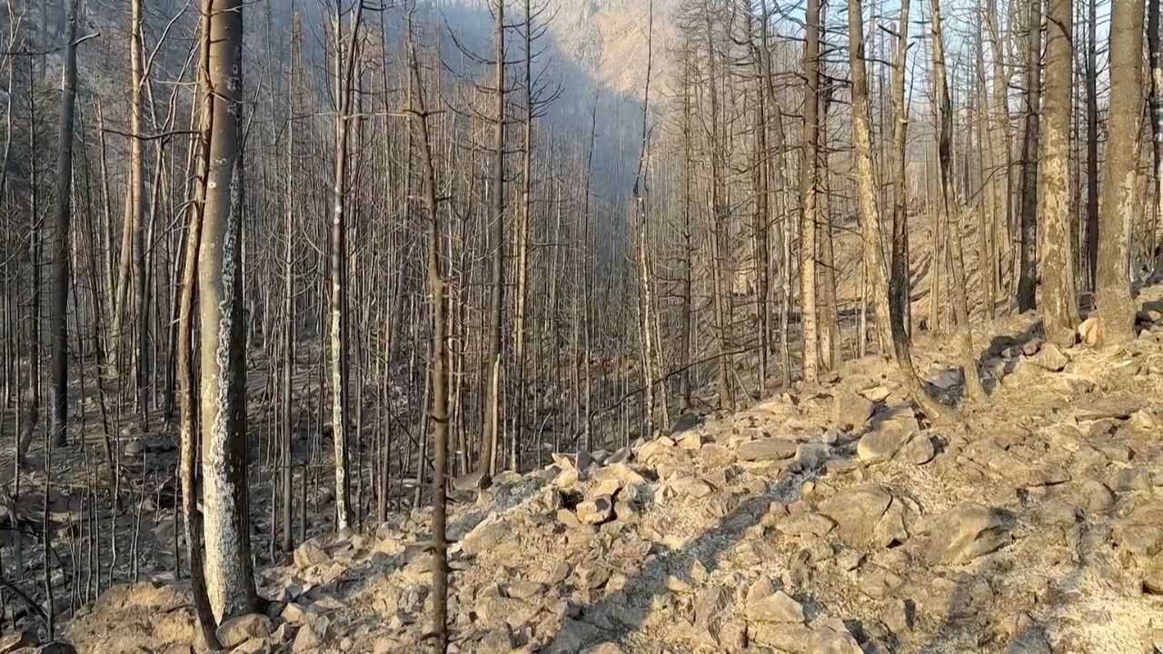
As of 2026-06-28 23:36 UTC, the Snyder Fire is no longer just one more red-flag-weather incident in the West. Three firefighters were killed and two were burned after a burnover in Mesa County, Colorado, while fast-moving fires near the Colorado-Utah line merged into a larger Snyder Fire footprint.[1][5]
The practical story is timing. A forecast can say the air will be hot, dry, and windy; incident commanders still have to decide when crews can hold ground, when residents should move, when public lands should close, and when perimeter or containment numbers are too provisional to use as comfort. AP reported that the firefighters deployed emergency shelters during the burnover, that their names were being withheld pending family notification, and that the fire had burned about 44 square miles by Sunday reporting.[1] The Colorado Sun, citing state and federal response details, reported a 28,200-acre Snyder footprint west of Fruita and Grand Junction and 0% containment by midmorning Sunday.[5] Those numbers are close in scale, but they should still be treated as live incident estimates, not settled final acreage.
Fact File
| Time / source | Key claim | Confidence note |
|---|---|---|
| June 28, AP | Three firefighters were killed and two sustained burn injuries after being overcome by flames during a burnover in Mesa County; AP says the firefighters deployed emergency shelters.[1] | High for casualty count and burnover description as reported by AP and the Interior Department. Names remain withheld. |
| June 28, Colorado Sun | The Snyder Fire developed from the Knowles and Gore fires near the border area, crossed drought-parched land, and reached about 28,200 acres with 0% containment by Sunday midmorning reporting.[5] | Medium-high; acreage and containment are operational estimates that can change with mapping flights and shift reports. |
| June 28, NOAA/SPC | The Day 1 Fire Weather Outlook introduced a targeted Extremely Critical area, citing sustained southwesterly 25-35 mph winds, 5-10% relative humidity, exceptionally dry fuels, and ongoing wildfires.[3] | High for forecast language; it is not, by itself, a causal finding about any one burnover. |
| June 28, BLM | The Bureau of Land Management closed all BLM-managed public lands in McInnis Canyons National Conservation Area, plus nearby BLM lands north of DS Road and west of 16 1/2 Road, until the fire is controlled or the order changes.[4] | High for closure scope and public-safety rationale. |
| June 28, NIFC | The National Interagency Fire Center said 104 new fires were reported nationwide the previous day, including six new large fires, and firefighters were working 36 large fires nationally; it also identified Cottonwood near Beaver, Utah, as the nation's largest current fire.[2] | High for national operating context; the page updates, so figures are a current snapshot. |
What Changed
The fatality report changes the frame from "large fires in bad weather" to "crew exposure under fast-changing fire behavior." A burnover is the moment firefighters are overtaken or cut off by flame movement; AP described this one as occurring after fast-moving fires closed off escape routes and forced emergency shelter deployment.[1] That is the detail that should keep the public reading the rest of the incident cautiously. The public often sees acreage first. Fire crews experience rate of spread, wind shifts, terrain, fuels, lookout-communication-escape-safety discipline, and whether a retreat route still exists.
The Snyder Fire also sits inside a broader Utah-Colorado outbreak rather than a single isolated ignition. AP reported the Knowles and Gore fires merged with other fires to form Snyder, while Cottonwood in southwest Utah ballooned to more than 146 square miles after burning through canyons and mountainsides and damaging part of a ski resort and summer cabins.[1] NIFC's national update makes the scale problem clearer: dozens of large fires are competing for crews, aircraft, incident-management capacity, and public-information bandwidth.[2]
Weather is the second hard boundary. NOAA's Storm Prediction Center highlighted an Extremely Critical fire-weather area where strong southwest winds, very low humidity, dry fuels, and existing fires overlapped.[3] AP separately reported that Grand Junction reached 93F on Saturday and saw winds gust to 44 mph.[1] None of that proves the exact sequence of the fatal burnover; investigations will have to do that work. It does explain why evacuation and closure decisions cannot wait for perfect perimeter certainty.
BLM's McInnis Canyons closure is the clearest public sign of that operating posture. The agency said the closure was issued because of public health and safety, rapid spread, and fire behavior, and told the public to remain clear of the lands.[4] The point is not only to keep visitors from seeing smoke. It is to keep roads, trailheads, river corridors, and backcountry access from turning into new rescue tasks while crews are already working under hazardous conditions.
Decision Impact
Next 24 hours: the priority is to keep people and crews out of the fire's next path. Residents under pre-evacuation or evacuation advisories should treat them as movement instructions, not as weather commentary. Closures should be read literally: a closed conservation area, road, campground, or trailhead is not a judgment about personal skill, but a way to keep incident traffic and emergency egress clear.[4][5]
Next 7 days: the key test is whether the incident can move from rapid expansion to mapped containment without further crew or public exposure. Watch for updated perimeter mapping, containment changes, shelter and road information, aircraft availability, and whether weather relief actually reaches the fire area. NIFC's resource-sharing note matters here: wildfire response does not follow state lines, so Utah and Colorado conditions can pull on the same national crew and aviation pool.[2]
Next 30 days: the story will split into two files. One is the immediate fire file: acreage, structures, evacuations, closures, containment, rehabilitation, and utility or road damage. The second is the fatality-review file: what the crews were assigned to do, what communications and escape routes were available, how the wind and fuel conditions changed, and what the shelter deployment reveals. Those answers should come from official investigation channels, not from early public speculation.
Scenarios
Base case: weather moderates enough for crews to improve line construction, mapping reduces uncertainty, and evacuation or pre-evacuation zones become more precise. Snyder remains dangerous, but the public-information problem becomes manageable: clear closure maps, regular acreage/containment updates, and no new burnovers or rescues.[2][4][5]
Upside case: containment improves faster than expected, the BLM closure can be narrowed, Cottonwood and other Utah fires stop drawing as heavily on regional resources, and local officials can transition some evacuees from "leave now" or "be ready" messaging to controlled return planning. The proof would be sustained containment gains, fewer new starts, and weather that stops aligning wind with receptive fuels.[2][3]
Downside case: wind-driven growth outruns mapping again. The warning signs would be expanded closures, more evacuation orders, aircraft grounded by smoke or wind, additional road or campground closures, or new fires started by lightning holdovers while crews are still committed to Snyder and Cottonwood. Under that scenario, yesterday's acreage is the least useful number in the story; the decision clock is where the fire can be by the next wind shift.[2][3][4]
Action Checklist
- Treat all acreage and containment numbers as timestamped snapshots. If an update does not say when it was measured, do not use it to judge current personal risk.[1][5]
- Follow evacuation and pre-evacuation notices from local officials before following incident maps. Maps often lag wind-driven movement.
- Stay out of closed BLM lands in McInnis Canyons National Conservation Area and adjacent closure zones until the order is amended, rescinded, or the fire is controlled.[4]
- For residents near the fire path, prepare documents, medications, pets, livestock plans, fuel, chargers, and a route before an evacuation order arrives.
- For regional monitoring, watch NIFC and NOAA/SPC together: incident size tells where resources are committed; fire-weather outlooks tell where existing commitments can become more dangerous.[2][3]
- Reassess the story if official investigators change the burnover timeline, if containment updates show sustained control, or if new weather shifts create another rapid-spread window.
The main invalidation condition is a sequence of official updates showing that wind has eased, containment has risen materially, closures have narrowed, no additional evacuation zones are needed, and preliminary fatality-review facts point to a narrow incident rather than a broader red-flag operations problem. Until then, the disciplined reading is narrower and more urgent: the Snyder Fire deaths turn weather language into an evacuation and crew-safety clock.
Sources
- Julie Smyth, Associated Press, "3 firefighters killed, 2 injured while tackling wildfires on the Colorado-Utah border" (June 28, 2026) - casualty count, burnover description, Snyder and Cottonwood fire context, weather notes, and AP cover photograph.
- National Interagency Fire Center, "National Fire News" (June 28, 2026 update) - nationwide new-fire and large-fire counts, Cottonwood largest-fire status, year-to-date wildfire acreage, national resource-sharing note, and fire-weather summary.
- NOAA Storm Prediction Center, "Jun 28, 2026 Day 1 Fire Weather Outlook" - targeted Extremely Critical fire-weather area, wind and humidity ranges, dry-fuel conditions, and ongoing-wildfire risk.
- Bureau of Land Management, "BLM closes public lands in McInnis Canyons National Conservation Area due to Snyder Mesa Fire" (June 28, 2026) - emergency closure scope, duration, and public-safety rationale.
- Jason Blevins, The Colorado Sun, "Three federal firefighters killed in Mesa County as Snyder wildfire exploded in high winds" (June 28, 2026) - local reporting on the burnover, shelter deployment, Colorado response, pre-evacuation orders, acreage, and containment estimate.