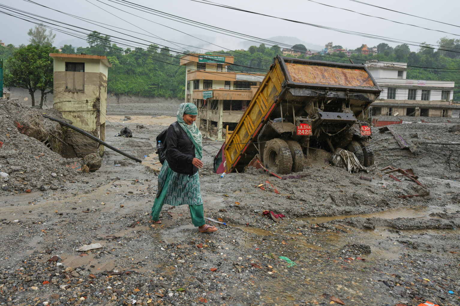
As of 2026-08-29 06:35 UTC (12:20 NPT), helicopters had resumed flying in parts of flood-hit Nuwakot after poor weather interrupted operations earlier Saturday. That restart was good news, but it also exposed the central weakness in Nepal's fourth day of rescue work: aircraft are carrying jobs that roads and bridges would ordinarily do, and the sky can close faster than a ground route can be rebuilt.[2][3]
The latest consolidated update cited here, issued by Nepal's National Disaster Risk Reduction and Management Authority at 10:00 NPT, reported 626 deaths, 2,426 people unaccounted for, 4,451 people rescued, 101 injured people in hospital, and 15,224 security personnel mobilized.[1] Those are time-stamped operational figures, not a final toll. “Unaccounted for” does not mean confirmed dead, and lists can change as communications return, duplicate names are reconciled, and search teams reach new locations.
The number that explains the access problem is 41. Nepal's Department of Roads said about 40 kilometres of road between Rasuwagadhi and Malekhu had been damaged and 41 bridges destroyed or damaged. The government has sought Indian and Chinese help to install 42 Bailey bridges.[2] Until temporary crossings and continuous road corridors exist, every forecast, landing zone, fuel load and helicopter rotation is part of the relief network.
What is verified at the cutoff
| Question | Verified position | Confidence and uncertainty boundary |
|---|---|---|
| How large is the recorded human toll? | NDRRMA's 10:00 NPT update reported 626 dead and 2,426 unaccounted for in Nepal, with 4,451 rescued.[1] | High for that bulletin, low as a final total. The figures were changing rapidly and should always travel with their timestamp. |
| Are helicopters operating? | Poor weather stopped flights on Saturday morning; AP journalists saw operations resume in Nuwakot before noon. Search continued on the ground, including at the Upper Trishuli-1 hydropower site.[3] | High for observed local conditions. A resumption in Nuwakot does not prove every route or landing zone was open. |
| Why can aircraft not solve the whole problem? | AP reported limited landing areas and mud 1.2–1.5 metres deep at the hydropower site. Local reporting describes communities, patients and schools cut off by missing roads and crossings.[2][3] | High for the named locations. Conditions vary across the affected corridor. |
| What has happened to ground access? | The Department of Roads' preliminary account put damage at roughly 40 kilometres of road and 41 bridges, with 42 temporary bridges requested.[2] | Moderate to high. It is an official preliminary assessment; a full engineering survey may revise both the count and repair sequence. |
| What relief burden is emerging? | WHO says around 10,000 households need immediate relief; three health posts were fully damaged, one hospital partly damaged, and access to two hospitals affected.[5] | Moderate. WHO explicitly says assessments of communities, infrastructure and health services are continuing. |
| Is a second flood surge ruled out? | Chinese monitoring relayed by AP said the upstream barrier lake's level had fallen 10 metres from Thursday's peak by late Friday. UN disaster officials nevertheless called for vigilance against cascading mountain hazards.[3][4] | No all-clear. A reported fall in one lake is not a basin-wide guarantee against another surge, landslide or blockage. |
A road failure measured in ordinary journeys
The bridge count becomes concrete in Bidur, where a trip between neighbourhoods in the same municipality turned into an airlift. The Kathmandu Post reported that 40 students and teachers were flown from Tribhuvan Trishuli Secondary School to Bidur on Friday, while others still waited. Local officials said about 100 children stranded on both sides of the Trishuli had been brought back to their families.[2]
Elsewhere, residents were sheltering in surviving community buildings, patients could not reach referral care, and relief supplies were not moving reliably from nearby staging points. One school was feeding roughly 450 students and residents from its midday-meal stocks because outside supplies had not reached them.[2] These accounts do not establish that every settlement is isolated. They show how the same broken crossing can become a school, health, food and family-reunification problem at once.
That is why the deployment of more than 15,000 security personnel cannot be read as equivalent to 15,000 people reaching the places of greatest need. Personnel require a safe route, communications, transport, fuel, medical support and a way back. When a helicopter is the only connection between wards, its payload must compete among evacuation, search teams, medicine, food, shelter material and equipment.
The United Nations described the operation on Friday as government-led and heavily supported by Nepal's military and security services. It also said many areas were reachable only by helicopter and cited an early Red Cross estimate that about 93,000 people might have been affected.[4] That estimate and Friday's casualty count are older than Saturday's national update; they are useful for the scale of need, not as the latest tally.
Search and relief are now running together
The first emergency remains search and rescue. AP reported that more than 100 people were believed trapped in a mud-filled tunnel at the Upper Trishuli-1 hydropower project. Rescuers were using baskets and ropes where landing space was scarce.[3] Missing-person work also depends on merging lists from families, employers, trekking and pilgrimage groups, local authorities and both sides of the border. Nepal's Ministry of Foreign Affairs created an Emergency Control Room specifically to verify information and coordinate assistance for affected foreign nationals.[6]
The second emergency is continuity of daily life. WHO's current priorities include trauma care, safe water, disease surveillance and restoration of essential health services. It has mobilized an emergency health kit intended to cover nearly 10,000 people for three months, alongside tents and other supplies.[5] A kit in a warehouse, however, is not care in a cut-off settlement. The decisive measure is whether supplies, staff and patients can move repeatedly—not whether a single delivery or evacuation succeeds.
The flood's initiating mechanism also remains under assessment. WHO says preliminary information points to a sudden surge from Tibet, possibly connected to an upstream ice avalanche and temporary damming of the Lhende River.[5] That language matters. Satellite and field evidence may sharpen the explanation, but the current operational report should not turn a leading hypothesis into a settled forensic conclusion.
The next 24 hours, seven days and 30 days
In the next 24 hours, the rescue margin depends on safe flying windows, usable landing zones, river and slope monitoring, and repeated ground checks at priority sites. A regional flight resumption is not an all-day guarantee. The most useful public update would combine aircraft status with named road sections, bridge crossings and settlements that remain unreachable.
Over the next seven days, the focus should widen from people reached to service sustained: how many isolated communities receive repeat deliveries, which health facilities regain referral routes, where temporary crossings can safely carry ambulances and trucks, and whether missing-person lists are being reconciled rather than merely accumulated. Temporary bridge installation is important, but access on each side of a bridge must also be passable.
Over the next 30 days, the key transition is from weather-dependent lift to redundant ground access. That does not require every permanent bridge to be rebuilt. It requires a verified network of temporary crossings, alternate roads, fuel and supply hubs that can continue operating when aircraft cannot. WHO's three-month health-supply horizon is a reminder that the emergency will outlast the search phase.[5]
When the access network holds—or fails
Base case — intermittent air access, gradual ground repair. Helicopters continue during suitable weather, temporary crossings are installed in sequence, and relief reaches more communities, but some places remain dependent on irregular deliveries. Trigger: daily operations show flights and partial road reopenings without a continuous truck-capable route through the worst-hit corridor.
Upside case — a reliable ground spine returns quickly. Alternative road sections and priority Bailey bridges connect staging hubs to isolated municipalities, allowing aircraft to concentrate on search, medical evacuation and locations that roads cannot serve. Trigger: authorities publish verified, load-rated routes that carry repeated relief and ambulance traffic across multiple days.
Downside case — another hazard or weather closure breaks the thin network. Renewed flooding, landslides or prolonged low cloud closes landing zones while roads remain severed, delaying rescue and increasing water, sanitation and health risks in crowded shelters. Trigger: new evacuation orders, another sustained flight suspension, additional route losses or further health-facility disruption.[3][4][5]
These paths are operating conditions, not probability forecasts.
What to do—and what would change this report
- Families seeking a foreign national should use Nepal's Foreign Ministry Emergency Control Room: +977-9744441227 or +977-9744441228, open 07:00–22:00 NPT, or
[email protected].[6] - Readers and newsrooms should attach a time to every casualty or missing-person figure, distinguish “unaccounted for” from confirmed death, and replace old totals rather than combining them.
- Response updates should publish access as a network: flight status, functioning landing zones, road sections, temporary crossings, health referrals and settlements still unreachable.
- Relief planning should test repeat delivery. One helicopter arrival proves contact; it does not prove a durable food, water, medicine or evacuation route.
- Hazard reporting should preserve the evidence boundary around the flood's cause and avoid treating a falling barrier-lake level as a general all-clear.[3][4][5]
Invalidation condition: the article's central assessment—rescue and relief are unusually dependent on flight weather—would need revision once authorities verify a continuous, all-weather ground corridor with enough capacity for sustained relief and medical transport into the isolated areas. A revised engineering survey that materially lowers the 41-bridge preliminary count would also require the headline and access map to be updated. Changing casualty figures alone would update the scale of loss, but not the access mechanism described here.
For now, Nepal's response has people, aircraft and supplies in motion. What it does not yet have is enough redundancy. The rescue network remains strongest when the clouds lift.
Sources
- Pritam Bhattarai, The Kathmandu Post, “Updates: Bhotekoshi flood toll reaches 626 as 2,426 remain unaccounted for” (August 29, 2026) — NDRRMA's 10:00 NPT casualty, missing, rescue, treatment and personnel update.
- Sudeep Kaini and Poshnath Adhikari, The Kathmandu Post, “Washed-out bridges force flood-hit communities to rely on choppers” (August 29, 2026) — road and bridge damage, temporary-bridge request, local airlifts and access accounts.
- Shristi Kafle and Victoria Milko, Associated Press, “Rescuers search for thousands missing after floods at Nepal-China border” (August 29, 2026) — flight disruption and resumption, hydropower-tunnel rescue, barrier-lake monitoring and source page for Rajesh Kumar Singh's cover photograph.
- United Nations Office at Geneva, “UN Geneva Press Briefing” (August 28, 2026) — government-led response, helicopter-only access, preliminary affected-population estimate and cascading-hazard warning.
- World Health Organization Nepal, “Nepal: flash floods and health response” (updated August 2026) — affected districts, preliminary cause boundary, household and facility impacts, health risks and emergency supplies.
- Ministry of Foreign Affairs, Government of Nepal, “Emergency Control Room for Assistance regarding Foreign Nationals Affected by the Bhote Koshi Flash Flood” (August 27, 2026) — official verification and consular-assistance contacts.