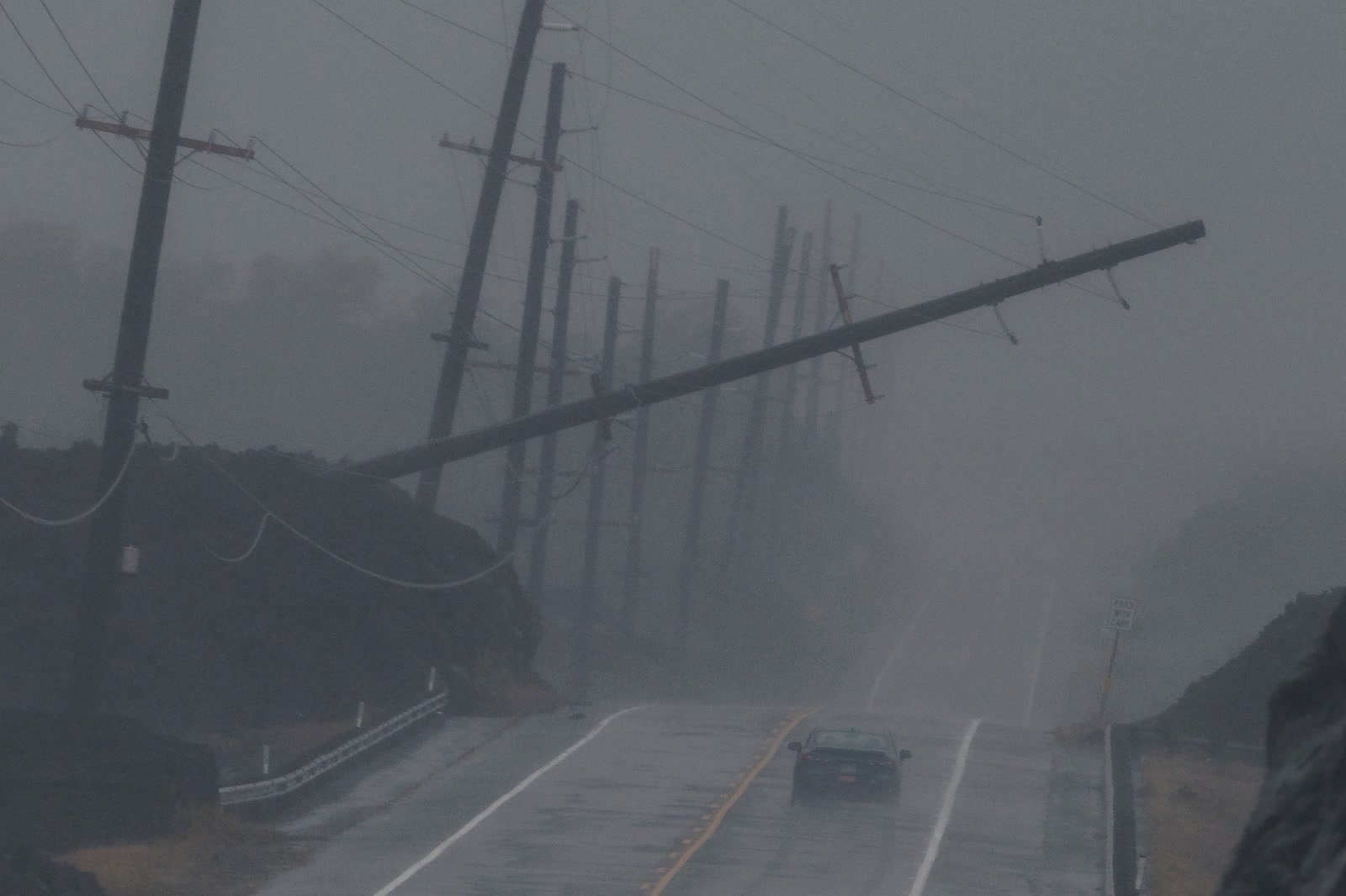
As of 11:00 p.m. HST Saturday, August 15 (09:00 UTC Sunday, August 16), Lala's center remained offshore west of Hawaiʻi Island. AP reported that it had passed the island's southern tip without making landfall.[1] That is welcome news. It is not an all-clear.
National Hurricane Center Advisory 16, valid at 11:00 p.m. HST (09:00 UTC), still classified Lala as a 75 mph hurricane. Its center was 65 miles west of Kailua-Kona and moving northwest at 15 mph; tropical-storm-force winds extended as far as 175 miles from the center. A hurricane warning remained in force for Hawaiʻi County, while tropical storm warnings covered Maui County, Oʻahu and Kauaʻi County.[2]
No landfall is a useful track finding. It should never appear without the hazard status. The center is a point; the storm is a field. Headlines, travel decisions and reopening calls should follow the field.
The line Lala did not cross
The Associated Press reported that Lala's eye passed the island's southern tip without landfall.[1] In meteorology, that term has a narrow job. The National Hurricane Center defines landfall as the intersection of a tropical cyclone's surface center with a coastline. Its definition immediately adds the important caveat: the strongest winds can be experienced over land even when landfall does not occur.[3]
That distinction fits Lala almost exactly. Advisory 16 reported a maximum tropical-storm-force wind extent of 175 miles, but that radius is not an even circle and should not be read as one. More decisive were the active warnings and the forecast itself: damaging winds were expected to persist on Hawaiʻi Island, tropical storm conditions to spread west across the smaller islands, and rainfall to keep producing life-threatening flooding and mudslides. The advisory forecast another 4 to 8 inches for Hawaiʻi Island and windward Maui, with a maximum storm total of 30 to 35 inches over windward Hawaiʻi Island—not an observed 35-inch total.[2]
"No landfall" therefore describes the geometry of the center and coast. It does not score the wind, rain, water, falling trees, power network or roads. The term belongs in the coverage because it is true and historically meaningful. It just cannot support an all-clear by itself.
What officials reported by the cutoff
| Signal | Reported fact | Limits |
|---|---|---|
| Track | AP reported that the eye passed south of Hawaiʻi Island without landfall.[1] Under the NHC definition, that means the surface center did not intersect the coast.[3] | A later official best-track analysis could refine the path and would supersede this real-time account. |
| Storm and warnings | At 11:00 p.m. HST (09:00 UTC), Lala was a 75 mph hurricane moving northwest at 15 mph. A hurricane warning covered Hawaiʻi County; tropical storm warnings covered Maui County, Oʻahu and Kauaʻi County.[2] | This is a time-limited advisory snapshot, not a promise that conditions will remain unchanged. |
| Roads and transport | Hawaiʻi's transport status page listed closures caused by flooding, fallen trees, electrical lines and a landslide on Hawaiʻi Island; it also showed later tree-related restrictions on Maui and Oʻahu, airport disruption and closed commercial harbors.[5] | Entries were reported and timestamped by agencies on the page; conditions differ by island and can change faster than the page is revised. |
| Electricity | Hawaiian Electric said approximately 88,030 customer accounts on Hawaiʻi Island, in Maui County and on Oʻahu were without power at 7:00 p.m. HST (05:00 UTC). It said dangerous conditions had stopped or constrained some restoration work.[6] | This is a utility snapshot, not a live total. The company says outages and restorations can move the count in both directions. |
| Protective posture | HI-EMA's 5:00 p.m. HST (03:00 UTC) update told people statewide to shelter safely, avoid unnecessary travel and expect outages; its hub linked open shelters for Hawaiʻi, Maui, Honolulu and Kauaʻi counties.[4] | This was the hub's displayed guidance at that time. County alerts and newer official notices control when advice changes. |
Those reports are not a final damage assessment. They do not show that every island or neighborhood faced the same severity. They establish something narrower and already sufficient: an offshore center coexisted with hazards and emergency operations on land.
The impact ledger has outrun the near-miss story
On Hawaiʻi Island, HDOT's status ledger recorded stretches of Route 11 blocked by trees, debris and flooding; Route 19 closures involving trees, electrical lines and a landslide; and a full flood closure of Hilo's Bayfront Highway. On Maui, Hana Highway was restricted to local traffic amid trees and a landslide. On Oʻahu, the Pali Highway had late-evening lane closures after a tree fell. Major commercial harbors were listed as closed, while airport status depended on the island and carrier.[5]
AP, attributing Governor Josh Green, reported that at least one person died in a South Point-area car crash, 19 roofs were lost and 190 flights were postponed.[1] These were early figures relayed by a news organization, not a final official toll. The cited account does not establish that weather caused the crash.
The electrical ledger was just as concrete. Hawaiian Electric's 7:00 p.m. HST (05:00 UTC) count included 63,270 customer accounts on Hawaiʻi Island, 15,260 in Maui County and roughly 9,500 on Oʻahu. The utility said some customers would remain without electricity overnight because crews first had to wait for safe access, inspect damage and make repairs.[6] That is not institutional delay that can be wished away; it is another storm hazard.
HI-EMA's hub linked shelters in Hawaiʻi, Maui, Honolulu and Kauaʻi counties and directed residents to county alerts.[4] AP's lead photograph—the image above—records a vehicle driving in heavy rain near a pole dangling above Māmalahoa Highway.[1] It documents dangerous conditions; it does not establish whether that stretch was officially open.
None of this proves a catastrophic statewide outcome, and it should not be inflated into one. It proves that near miss is usable only with an object: a near miss for the surface center making landfall. As a summary of what communities and infrastructure experienced, it is already too broad.
Why the vocabulary matters
Landfall is useful for storm records and track analysis because it answers a binary question. People making decisions need different answers: Is my warning still active? Is the road inspected? Is the shelter open? Is the airport operating and my flight moving? Can a power crew reach the line safely?
AP's own headline did the responsible thing: it paired the no-landfall finding with heavy wind and rain.[1] That should be standard. There is no evidence in the sources here that a particular headline caused a person to take a particular risk. The preventive rule is more modest: every prominent "no landfall" line should be paired with the live warning footprint and at least one ground-status ledger.
A concise formulation is: Lala's center stayed offshore; dangerous conditions and recovery constraints continued. That sentence leaves room for relief without inventing safety.
Three clocks now running
Next 24 hours — hazards and access. Residents and visitors should treat NHC and local NWS products, county alerts, HI-EMA shelter guidance and HDOT closures as the controlling evidence, not the position of the eye by itself.[2][4][5][7] Travelers should confirm both the facility status and the specific carrier's service before moving. Restoration estimates should remain conditional on crews gaining safe access.[6]
Next 7 days — inspection and restoration. The story should migrate from forecast maps to verified reopenings: roads cleared and inspected, harbors and airports returned to service, shelters closed safely, outage totals falling, debris removed and damage assessments dated. Early disruption counts should remain labeled as snapshots rather than silently becoming a final toll.
Next 30 days — the after-action record. Agencies and newsrooms should compare the timeline of center-focused updates with the timelines for warnings, closures and outages. The useful question is not whether anyone used the word landfall. It is whether each use helped readers distinguish track from exposure. Infrastructure reviews should follow the documented trouble spots—tree corridors, transmission access and transport chokepoints—rather than the offshore path alone.[5][6]
Three conditional paths
These are branches to watch, not probabilities.
Base path — the storm moves away, then recovery advances unevenly. Lala follows the official westward track and weakens, warnings contract, and crews reopen access island by island. Trigger: successive weather advisories reduce hazards while HDOT and Hawaiian Electric report sustained restoration rather than one-hour improvement.[2][5][6]
Upside path — the trailing footprint clears quickly. Rain bands ease, inspections find limited additional damage, shelters close safely, major routes and ports reopen, and outage totals fall sharply. Trigger: flood alerts expire without replacement and separate official operating ledgers converge on normal service.[4][5][6][7]
Downside path — secondary effects outlast the center's passage. Additional rain over saturated terrain produces new flooding or slope failures, blocked access slows repairs, and power or transport disruption cascades. Trigger: warnings are extended, new closures appear, shelters stay open or outage totals remain high after conditions were forecast to improve.[2][4][5][6][7]
What supports a local all-clear
- NHC and local NWS warnings and flood alerts have been withdrawn or narrowed for the relevant location.[2][7]
- County and HI-EMA notices replace shelter and avoid-travel guidance with explicit local updates.[4]
- HDOT reports inspected routes, airports and harbors reopened—not merely a forecast reopening time.[5]
- Current and subsequent Hawaiian Electric updates show a sustained restoration trend and identify the areas where access or repairs remain constrained.
- Every casualty, damage, closure and outage figure carries a source and observation time; preliminary numbers are corrected rather than fossilized.
The event-level claim that Lala's hazards remain active should be treated as expired when official warnings recede and local operating agencies report safe conditions. The no-landfall premise must be corrected if post-storm analysis finds that the center did cross the coast. Final assessments may also show a smaller or larger impact than the early ledgers suggest.
Those updates would change the event record, not the communication principle. A landfall line tells us where the center went. An all-clear has to be earned where people are.
Sources
- Alexa St. John and Ed White, Associated Press, "Hurricane Lala skirts Hawaii's Big Island without making landfall as heavy wind, rain lash region" (August 15–16, 2026; accessed 09:00 UTC August 16) — track reporting, initial impacts and provenance for the article photograph.
- National Hurricane Center and Central Pacific Hurricane Center, "Hurricane Lala Advisory Number 16" (09:00 UTC, August 16, 2026) — position, intensity, wind field, warnings and hazard forecast.
- National Hurricane Center, "Glossary: Landfall" — the operational definition of landfall and the boundary between center crossing and wind impacts.
- Hawaiʻi Emergency Management Agency, "Hurricane Lala Updates" (last displayed update 5:00 p.m. HST, August 15; accessed 09:00 UTC August 16, 2026) — statewide safety guidance, county alert links and shelter status.
- Hawaiʻi Department of Transportation, "Weather Related Traffic Alerts" (accessed 09:00 UTC, August 16, 2026) — timestamped highway, airport and harbor operating status by island.
- Hawaiian Electric, "8 p.m. update: Dangerous weather conditions slow Hawaiian Electric power restoration efforts" (August 15, 2026) — the 19:00 HST outage snapshot and restoration constraints.
- National Weather Service Honolulu, "Current Watches, Warnings and Advisories" (accessed 09:00 UTC, August 16, 2026) — the local hazard-alert index for the Hawaiian Islands.