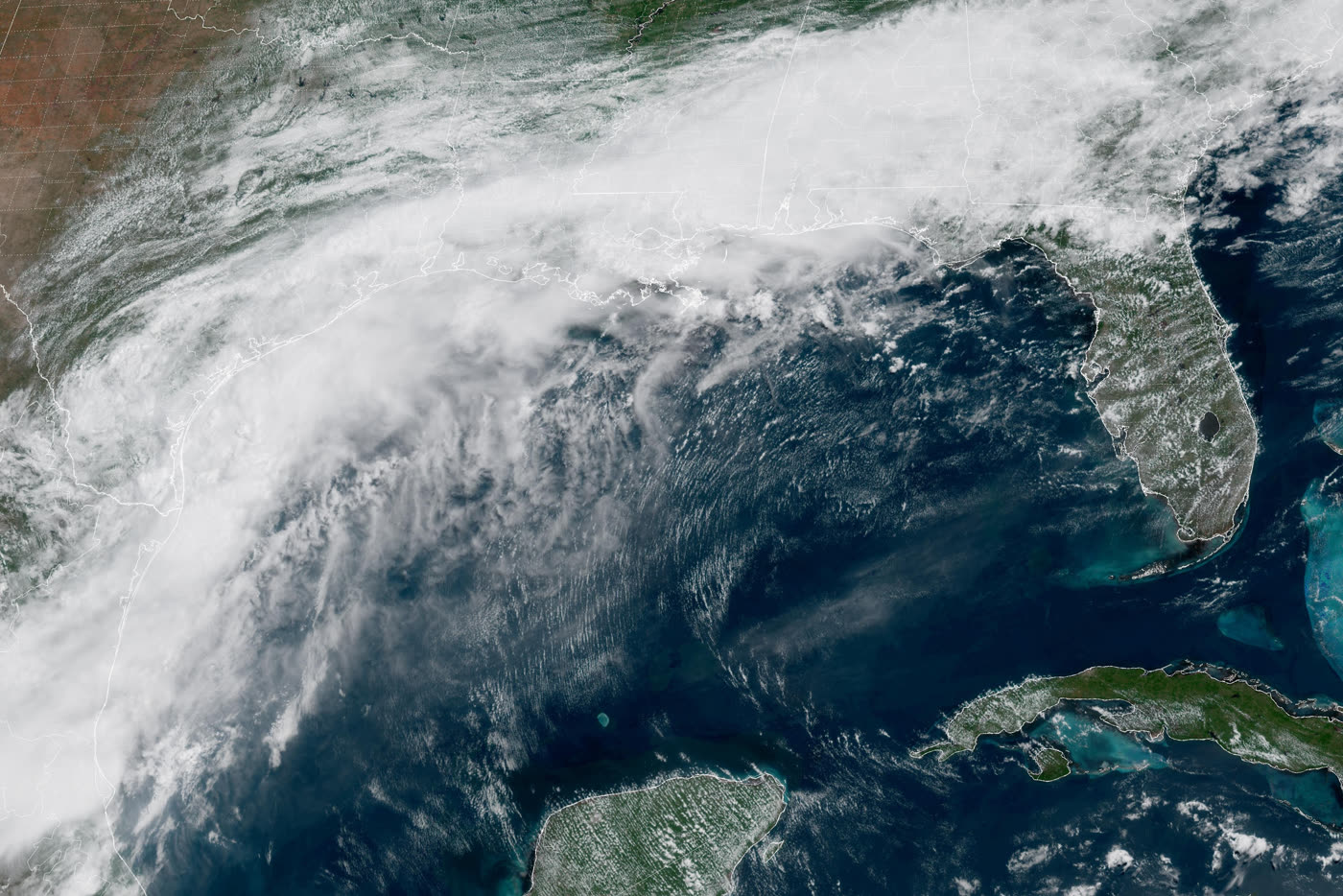
As of 2026-06-16 22:33 UTC, Potential Tropical Cyclone One is still a weak system by wind speed and a serious system by water. The National Hurricane Center's 4:00 p.m. CDT advisory put the disturbance near 27.3N, 97.6W, about 35 miles south-southwest of Corpus Christi, with maximum sustained winds of 30 mph, a 1005 mb minimum central pressure, and a high 70% chance of becoming a tropical cyclone within 48 hours.[1]
That is the surface headline. The operational headline is sharper: NHC issued a tropical storm warning for the Louisiana coast from Sabine Pass to Morgan City, kept a tropical storm watch from Sargent to Sabine Pass, and warned that dangerous flash flooding was already continuing over parts of Texas and Louisiana.[1] In other words, the first named-storm question is less important tonight than the rain footprint.
This is also why NOAA's below-normal 2026 Atlantic seasonal outlook should not be read as a local all-clear. NOAA's seasonal forecast calls for 8-14 named storms, 3-6 hurricanes, and 1-3 major hurricanes, with a 55% chance of below-normal basin activity.[4][5] But a seasonal basin forecast is not a landfall forecast, and it is not a flood forecast for any one city or bayou. Potential Cyclone One is the early proof: a marginal, short-lived tropical system can still produce a high-impact water event.
Facts Now
| Item | Current signal | Confidence note |
|---|---|---|
| Latest NHC advisory | Advisory #2, issued 2100 UTC on June 16, placed the disturbance near the lower Texas coast with 30 mph sustained winds and a 70% formation chance.[1] | High; official NHC advisory. |
| Warning area | Tropical storm warning: Sabine Pass to Morgan City. Tropical storm watch: Sargent to Sabine Pass.[1] | High; warning boundaries can change with each advisory. |
| Rainfall threat | NHC forecast 5 to 10 inches, with isolated totals near 20 inches, from the Mid and Upper Texas coast into Louisiana, Mississippi, Alabama, western Georgia, and the Florida Panhandle through Thursday.[1] | High for forecast language; realized totals remain uncertain. |
| Primary hazard | NHC's discussion says heavy rainfall and life-threatening flash flooding are the primary hazards regardless of whether the system formally becomes a tropical cyclone.[2] | High; official forecast discussion. |
| Seasonal backdrop | NOAA and CPC both frame the 2026 Atlantic season as most likely below normal, mainly because expected El Nino conditions raise Atlantic wind shear.[4][5] | High for seasonal outlook; low for exact local impacts. |
| Independent report | AP reported that the Gulf Coast storms could become the first named tropical storm of the 2026 Atlantic season and highlighted flooding across Texas and Louisiana as the immediate risk.[7] | Medium-high; independent report relying on NHC and local context. |
The Mistake To Avoid
The common mistake is to put all hurricane-season risk on one ladder: tropical disturbance, tropical depression, tropical storm, hurricane, major hurricane. That ladder is useful for wind, but it can distort public attention. Potential Cyclone One sits low on the wind ladder. It is not forecast to become a hurricane. NHC's own discussion says most guidance shows a tropical storm on Wednesday, followed by quick weakening and dissipation over central Louisiana on Thursday.[2]
The water ladder is different. A slow tropical plume can load rain into the same drainage network for hours, then carry the problem inland after the coast has stopped watching the center. In Advisory #2, the rainfall envelope runs from the Texas coast into Louisiana, Mississippi, Alabama, western Georgia, and the Florida Panhandle.[1] The center track matters, but the rain shield is the thing that can turn an otherwise modest tropical system into a multi-state emergency.
That is also why "potential tropical cyclone" is not a soft label. NHC uses the designation when a system has not yet met the full tropical-cyclone definition but still requires watches or warnings. In this case, the label lets forecasters issue coastal warnings before the system has a tidy identity. The public-risk message is practical rather than taxonomic: prepare for tropical-storm conditions in the warning area, coastal flooding near the surge zone, dangerous surf and rip currents, and flash flooding well beyond the exact center.[1][2]
Why The Seasonal Outlook Still Matters
NOAA's 2026 outlook is not contradicted by this event. A below-normal season can begin with a flood threat. NOAA's seasonal numbers describe the likely total basin activity between June 1 and November 30, not the probability that a particular Texas or Louisiana community escapes one disruptive week.[4][5]
The reasoning behind the outlook is still relevant. CPC says El Nino is expected through the hurricane season, with the highest odds during the August-September-October peak, and that El Nino generally increases vertical wind shear over the Atlantic. More shear tends to disrupt the organization of tropical cyclones.[5] NHC's discussion of Potential Cyclone One fits that boundary: the system is close to depression status but still has imperfect structure, disorganized convection, and only a narrow window over warm Gulf waters before it moves inland.[2]
The counterweight is local moisture and timing. Warm Gulf water, a developing low, coastal convergence, and inland terrain do not need a major hurricane to create trouble. A below-normal season can still contain one bad Gulf rain event, one damaging surge setup, or one badly timed landfall. Seasonal activity is a planning baseline; emergency behavior has to follow the live hazard.
What Changes Next
The next 24 hours are about warning escalation, rainfall placement, and whether the circulation gains enough organization offshore to become Tropical Storm Arthur. NHC expects the disturbance to move offshore tonight, track roughly parallel to the upper Texas coast on Wednesday, and move back inland in extreme eastern Texas or southwestern Louisiana late Wednesday or early Thursday.[1] If the center spends more time over water or organizes faster, the wind field can matter more along the Louisiana coast. If it stays messy, rainfall can remain the dominant story anyway.[2]
The next 48 hours are a drainage and response problem. The Weather Prediction Center had already issued a mesoscale precipitation discussion for heavy rainfall and possible flash flooding near the middle and upper Texas coast earlier Tuesday, before the later NHC advisory expanded the high-end rainfall ceiling.[6][1] That sequencing matters: local flooding can start before the national headline settles on whether the storm gets a name.
The next seven days are a communication test for the rest of hurricane season. If the system becomes Arthur, the public will remember the name. If it never quite does, emergency managers still have to get people to treat the water risk seriously. The article's falsifier is simple: if rainfall totals underperform broadly and no significant flash, urban, river, surge, or rip-current impacts occur, then the event will have been more a warning exercise than a damaging Gulf flood. Until that is visible in observations and local reports, the safer read is that the name is secondary.
Scenarios
Base case: Potential Cyclone One briefly becomes a weak tropical storm or remains near that threshold, then moves inland by early Thursday. The main impacts are heavy rainfall, localized flash flooding, minor to moderate coastal flooding, rough surf, and scattered power or travel disruption along the Gulf Coast.[1][2]
Upside case: the center stays too close to land or too disorganized to intensify meaningfully, rain bands move faster than forecast, and local drainage systems avoid repeated training storms. Confirmation would be lower observed rainfall totals, fewer flash-flood warnings, and no persistent river-flood escalation.
Downside case: the system organizes just enough offshore to tighten winds while deep tropical moisture trains over the same coastal and inland zones. Confirmation would be repeated flash-flood emergencies, rainfall totals approaching the isolated high-end forecast, water rescues, road closures, and worsening river forecasts from Texas into Louisiana and Mississippi.[1][6]
Action Checklist
- Treat local NWS flood products as the decision trigger, not the storm name.
- If you are in the warning or watch corridor, check updated NHC advisories every few hours because coastal wind and surge boundaries can change quickly.[1][3]
- Do not drive across flooded roads; flash flooding is the central hazard NHC is emphasizing, even before a formal tropical-storm name is assigned.[1][2]
- For the rest of the 2026 season, keep the seasonal outlook in the right box: useful for preparedness and resource planning, insufficient for local risk dismissal.[4][5]
The cleanest reading is that Potential Cyclone One is a small storm-identity story and a large water-risk story. NOAA may still be right about a quieter Atlantic season. That does not make tonight quiet on the Gulf Coast.[4][5]
Sources
- NOAA National Hurricane Center, "Potential Tropical Cyclone One Public Advisory Number 2" (June 16, 2026) - current position, watches/warnings, rainfall, surge, surf, and tornado hazards.
- NOAA National Hurricane Center, "Potential Tropical Cyclone One Forecast Discussion Number 2" (June 16, 2026) - structure, track reasoning, intensity forecast, and key messages.
- NOAA National Hurricane Center, "Potential Tropical Cyclone ONE Advisory Archive (Text)" - official advisory timeline for AL012026.
- NOAA/AOML, "How does El Nino Impact Atlantic Hurricane Season" (June 2, 2026) - accessible NOAA explainer on the 2026 seasonal outlook and El Nino/wind-shear mechanism.
- NOAA Climate Prediction Center, "2026 Atlantic Hurricane Season Outlook" - forecast probabilities, expected activity ranges, and El Nino/wind-shear reasoning.
- NOAA Weather Prediction Center, "Mesoscale Precipitation Discussion #0430" (June 16, 2026) - heavy-rainfall and flash-flood setup near the middle and upper Texas coast.
- Associated Press, "Rain along the Gulf Coast could become the first named storm of the Atlantic hurricane season" (June 16, 2026) - independent report and NOAA GOES-19 satellite image used for this article.