The Treaty of Tordesillas is usually reduced to a schoolroom map: Spain on one side, Portugal on the other, a clean vertical stroke through the Atlantic. The document itself is more interesting because it is less clean. Signed at Tordesillas on June 7, 1494, it reads like a contract trying to turn uncertainty into procedure. Its key move was not simply to "divide the world." It converted a dispute over newly reached seas and lands into a bilateral rule: a north-south line 370 leagues west of the Cape Verde islands, with Castile's claims to the west and Portugal's claims to the east.[1][3]
That line mattered because it replaced a papal allocation with a negotiated Iberian bargain. In 1493, after Columbus's first voyage, Pope Alexander VI's bulls had favored Castile by setting a much narrower demarcation in the Atlantic. Portugal objected. At Tordesillas, ambassadors for Ferdinand and Isabella and for King John II moved the boundary westward, giving Portugal a safer Atlantic corridor and, after 1500, a legal basis for claiming the coast of Brazil.[1][3]
But the treaty's real historical pressure lies in the way it makes distance sound administratively manageable. Read closely, the text is not a confident map. It is a legal machine built around ambassadors, ratification, measurement, future discovery, and mutual restraint. The ocean is not known; it is being assigned.
The Opening Makes Power Delegated, Not Personal
The Avalon Project's English text begins with a long chain of representation. Ferdinand and Isabella's side is named through councillors and officers; Portugal appears through Ruy de Sousa, Joao de Sousa, and Ayres de Almada, acting under royal authority.[1] The bureaucratic density can feel tedious, but it is the first clue to how the treaty works. Empire here is not a solitary monarch pointing at a map. It is power delegated into negotiators who can bind crowns, heirs, successors, subjects, ships, islands, and future claims.
That matters because Tordesillas was attempting to govern things not yet fully seen. The treaty speaks of what had been discovered up to the date of the instrument and of what might later be found in the ocean sea.[1] This is not a border treaty between two surveyed farms. It is a rule for unknown arrivals. The document's confidence comes from legal form, not geographical certainty.
The timing also shows why form mattered. The UNESCO Memory of the World nomination describes the Portuguese state document as a parchment manuscript held in Torre do Tombo, with a ratification by Ferdinand and Isabella dated July 2, 1494.[2] The treaty had to move from negotiation to oath, from oath to archive, and from archive to usable diplomatic precedent. Its authority depended on being portable across courts and years.
The Line Is Precise And Vague At Once
The treaty's most famous clause is deceptively exact. A line 370 leagues west of Cape Verde sounds measurable. Yet a fifteenth-century league was not a neutral global unit, and longitude at sea was not yet something mariners could determine with later precision. The agreement made a number do political work before navigational practice could make it fully stable.[1][3]
That tension is the heart of the document. The line is precise enough to settle an argument between crowns. It is vague enough to generate future arguments about where, exactly, the line fell on coasts and across oceans. The treaty's success was therefore not that it removed ambiguity. It gave ambiguity an official grammar: distance from Cape Verde, west versus east, discovered versus undiscovered, spheres of navigation and conquest.
The 1502 Cantino planisphere shows why this mattered so quickly. World History Commons identifies it as a Portuguese manuscript world map made at the request of Alberto Cantino, an Italian agent in Lisbon, and notes that it showed recent Portuguese discoveries in Africa, India, Greenland, Newfoundland, and Brazil.[4] The map belongs beside the treaty because it reveals the same problem in visual form. New geographic information was valuable, partial, and politically charged. The line needed maps, but maps were themselves strategic objects.
The Treaty Narrows The Audience Of The World
One of the document's sharpest silences is who does not appear as a party. Tordesillas is a compact between two Christian Iberian crowns. It does not ask whether the people already living in the Americas, Africa, or Asia consented to being placed inside a European claims system. National Geographic's summary states the point directly: the treaty ignored millions of people already living in established communities in the Americas, and its consequences for societies such as the Taino, Aztec, and Inca were disastrous.[5]
That absence is not a footnote. It is built into the treaty's worldview. Britannica notes that the arrangement concerned newly discovered and undiscovered lands, while territory already held by a Christian ruler was excluded from occupation.[3] The category "Christian ruler" reveals the legal filter. Political legitimacy was recognized when it was legible to European Christendom; other sovereignties could be converted into objects of discovery, conquest, conversion, or trade.
This is why the phrase "divided the world" is both useful and misleading. Tordesillas did not divide the world in any enforceable universal sense. England, France, the Dutch Republic, and later other powers did not accept the agreement as binding on them.[3] The treaty divided claims between Spain and Portugal. Its reach expanded because those claims were carried by ships, forts, missions, trade routes, violence, settlement, and later law.
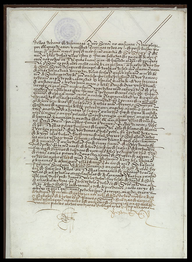
The Archive Keeps The Line From Looking Natural
The manuscript image attached to this article is useful because it resists the tidy map version of the story. A demarcation line can look natural once printed on a modern map. A manuscript page does not. It shows the treaty as a made object: written, copied, ratified, preserved, and reread.[6]
UNESCO's nomination file makes that material life explicit. It identifies the Portuguese document by shelfmark, describes the parchment format, and notes conservation in an archive vault under controlled conditions.[2] It also places Tordesillas in a longer treaty sequence: Alcacovas in 1479, papal confirmation in 1506, Zaragoza in 1529, and the Treaty of Madrid in 1750, which abolished the old Tordesillas meridian as part of a new South American boundary settlement.[2]
That sequence matters for interpretation. Tordesillas was not a single magic line that permanently organized the globe. It was an early modern instrument that later diplomacy revised, displaced, and invoked. Its power lay in making the idea of oceanic partition administratively thinkable. Once that idea existed, later maps and treaties could fight over where the line should fall, whether it still mattered, and what new facts on the ground had made it obsolete.
The Better Reading
A close reading of Tordesillas should therefore hold two ideas together. First, the treaty was a remarkably consequential legal device. It helped stabilize Iberian rivalry after Columbus, supported Portugal's Atlantic and Brazilian claims, and gave both crowns a language for overseas expansion.[1][2][3] Second, its clean legal structure depended on exclusions: uncertain measurement, partial maps, non-Iberian European rejection, and the erasure of non-European polities from the negotiating table.[3][5]
That is what makes the document still worth reading rather than merely remembering. It is not just a relic of an age of discovery. It is a record of how power can make ignorance actionable. The crowns did not need complete knowledge of the Atlantic or the Americas to write a rule. They needed enough authority to make a line, enough bureaucracy to preserve it, and enough force to act as if the paper could precede the world.
The treaty's most durable lesson is not that a line on a map explains Brazil or Spanish America by itself. It is that empires often begin by making a document sound more certain than the ground, water, and people it claims to organize.
Sources
- Yale Law School, Avalon Project, "Treaty Between Spain and Portugal concluded at Tordesillas; June 7, 1494," English treaty text and diplomatic framing.
- UNESCO Memory of the World Register nomination file, "Treaty of Tordesillas," archival provenance, physical description, bibliography, and related treaty sequence.
- Encyclopaedia Britannica, "Treaty of Tordesillas," overview of the 1494 agreement, the 370-league line, Brazil implications, and later European non-acceptance.
- World History Commons, "Cantino planisphere," source note on the 1502 Portuguese manuscript map and its depiction of recent Atlantic and Indian Ocean discoveries.
- National Geographic Society, "Jun 7, 1494 CE: Treaty of Tordesillas," historical article emphasizing the treaty's spheres of influence and its exclusion of Indigenous societies.
- Wikimedia Commons, "File:Folio02v.jpg," archival scan of an original page from the Treaty of Tordesillas, sourced to the Biblioteca Nacional de Lisboa.