The St. Francis Dam disaster is often remembered as the night Los Angeles water policy turned into a flood. Just before midnight on March 12, 1928, a concrete dam in San Francisquito Canyon failed and released more than twelve billion gallons of water down the Santa Clara River system.[4][5] The wave struck canyon workers, ranches, roads, bridges, towns, and farm country before reaching the Pacific near Oxnard. California's Office of Historic Preservation records the death toll as over 450; USGS gives at least 431, with the uncertainty itself part of the disaster's aftermath.[4][5]
The sharper history begins before the water moved. A dam failure is not only a flood event. It is a stored-energy event whose causes are laid into geology, design assumptions, inspection habits, and authority long before the breach. The St. Francis Dam mattered because several protective boundaries were treated as if they were stronger than they were: the canyon walls, the concrete gravity-arch form, the foundation contact, the operating judgment of a celebrated engineer, and the public oversight system around municipal dams.[1][2][3]
That is the mechanism this article follows. The dam did not simply "break" in an empty technical sense. It failed at the meeting point of a near-full reservoir, difficult rock, uplift pressure, seepage pathways, and a governance culture that had not yet made independent dam-safety review routine.[1][2][3] The flood was sudden. The conditions that made it possible were cumulative.
Timeline anchors
- 1925-1926: the City of Los Angeles built the St. Francis Dam in San Francisquito Canyon under the supervision of William Mulholland, then the city's powerful water chief.[2][4]
- March 12, 1928: the reservoir stood near its first full filling; just before midnight, the dam collapsed.[1][2][3][4]
- March 13, 1928: floodwater moved down San Francisquito Canyon and the Santa Clara River Valley, destroying homes, farms, bridges, roads, and power facilities.[3][4][5]
- 1928: Governor C.C. Young's commission published its investigation, explicitly presenting the report so the lessons of the failure would be made public.[1]
- August 14, 1929: California created the dam safety program that later became the Division of Safety of Dams, giving the state formal review and supervision powers over jurisdictional dams.[3]
- March 12, 2019: federal legislation designated the Saint Francis Dam Disaster National Monument and authorized a future national memorial, exactly 91 years after the failure.[6]
1. The first mechanism was stored water pressing on uncertain ground
The St. Francis Dam was built to hold emergency storage for the Los Angeles Aqueduct system, not as an isolated local project. USGS identifies it as a concrete gravity-arch dam built northwest of Los Angeles under Mulholland's direction.[4] The California Office of Historic Preservation gives the dam's height as 185 feet; a later Forest Service planning document describes it as about 200 feet high, an understandable difference between landmark and memorial summaries but a useful reminder that public memory often rounds disaster infrastructure into symbols.[5][6]
The important fact is not the exact height number. It is what height meant. A high reservoir turns water into pressure against concrete and rock. In a gravity dam, mass resists sliding and overturning. In an arching component, load can be transferred toward the abutments. Both ideas assume that the dam body and the canyon foundation cooperate. If the foundation is weak, discontinuous, water-softened, or able to admit uplift pressure, the apparent strength of concrete can be misleading.[1][2]
The 1928 governor's commission was appointed precisely because the state wanted an inquiry not connected to the design, construction, or operation of the dam.[1] Its conclusion, as summarized by California's present dam-safety history, was that the dam was poorly constructed and placed on a geologically unstable site.[3] That wording matters. It does not reduce the event to one bad crack or one unlucky rock bed. It frames the collapse as a failure of fit between a structure, a site, and the judgment that allowed the two to be joined.
2. Geology made the canyon a partner in the collapse
St. Francis Dam history turns on a simple point that is easy to miss from photographs: the canyon was not a uniform stone socket. Rogers and McMahon's reassessment describes a dam built across contrasting foundation materials and argues that earlier investigations placed too much emphasis on the right abutment because blocks from that side traveled farthest downstream.[2] Their later review instead returned attention to the whole dam-foundation system, including the left abutment, arching stresses, uplift, and ancient landslide conditions.[2]
That reassessment is valuable because it does not treat geology as scenery. Rock is part of the machine. A dam's foundation must resist not only vertical weight but also horizontal reservoir pressure, seepage, uplift, and stress concentration. A canyon wall can look massive while still containing planes of weakness, old slide material, weathered zones, or rock types that behave differently when saturated.[2][3]
The St. Francis site therefore shows why "built on rock" is not a sufficient safety claim. The question is what kind of rock, how it is fractured, how water moves through it, and whether the dam's shape pushes loads into places able to carry them. The physical canyon was not a passive container. It helped determine where pressure went, where seepage could travel, and where support could be lost.[1][2]
3. Uplift turned water into a hidden force under the dam
The most useful way to understand the failure is to stop picturing water only as a wave behind a wall. Water also acts where it cannot be seen. Rogers and McMahon emphasize that the designers did not properly consider uplift pressures acting along the dam base.[2] Uplift is the upward pressure water can exert beneath a structure when it enters joints, seams, or foundation contacts. It reduces the effective weight holding a gravity dam down, making overturning and sliding more likely.
This is why the failure could be both geologic and structural at the same time. If a reservoir reaches near full level, seepage pressure grows. If uplift reduces the stabilizing weight of the dam, the concrete mass no longer behaves as confidently as drawings suggest. If arching transfers force into abutments that are themselves uneven or compromised, parts of the system may carry more stress than expected.[2]
Rogers and McMahon propose a sequence in which excess arching stresses, block failures near the left abutment, seepage erosion, and possible reactivation of old landslide material combined into a progressive failure.[2] The exact initiating detail remains debated, as USGS notes, but the modern lesson is not uncertainty for its own sake.[4] The lesson is that dam safety cannot rely on a single visible explanation. It has to ask how several partially understood forces can compound under the first full loading of a reservoir.
4. First full filling was not a routine milestone
The phrase first full filling should slow the reader down. A reservoir's first high-water condition is a test of assumptions. It loads the dam and foundation at pressures not previously experienced in operation. Rogers and McMahon describe the St. Francis Dam as failing upon its first full filling near midnight on March 12-13, 1928.[2] In hindsight, that timing is not incidental. It is the moment when design confidence met maximum stored water.
There had been warning signs, including leaks and concerns observed before the collapse, but the dam's condition was interpreted through confidence in the structure and its designer rather than through a modern independent safety process.[1][2] This is the human part of the mechanism. Expertise is necessary for infrastructure, but concentrated authority can make weak signals easier to explain away. Mulholland's career and reputation were bound to the Los Angeles water system; the dam's risk was therefore embedded in a culture that trusted a powerful builder's judgment.[2][4]
The point is not to replace engineering analysis with biography. It is to see how biography and institutions shape what counts as alarming. A leak near a new dam can mean one thing in a system with independent geologic review, formal instrumentation, mandatory reporting, and power to restrict operation. It can mean something else in a system where the operating authority and the design authority are effectively the same center of confidence.[1][3]
5. Downstream geography converted collapse into mass fatality
Once the dam failed, the reservoir's stored energy became geography in motion. USGS describes roughly 12.4 billion gallons of water rushing down the canyon, with a wall of water reaching up to 140 feet in some places and moving at speeds up to 18 miles per hour.[4] California's dam-safety history describes a 70-foot wall of water, mud, trees, and boulders moving down San Francisquito Canyon into the Santa Clara River Valley, clearing a long swath to the ocean.[3]
Those numbers differ because flood height varies by location and source framing, but they agree on the historical mechanism: the canyon focused the release, then the valley distributed destruction. People did not face an abstract engineering failure. They faced a nighttime wall of water moving through work camps, homes, farms, roads, and towns. OHP records over twelve billion gallons flowing down the valley and more than 450 deaths.[5] USGS names Santa Paula, Fillmore, parts of Ventura, and downstream communities as places devastated by the flood.[4]
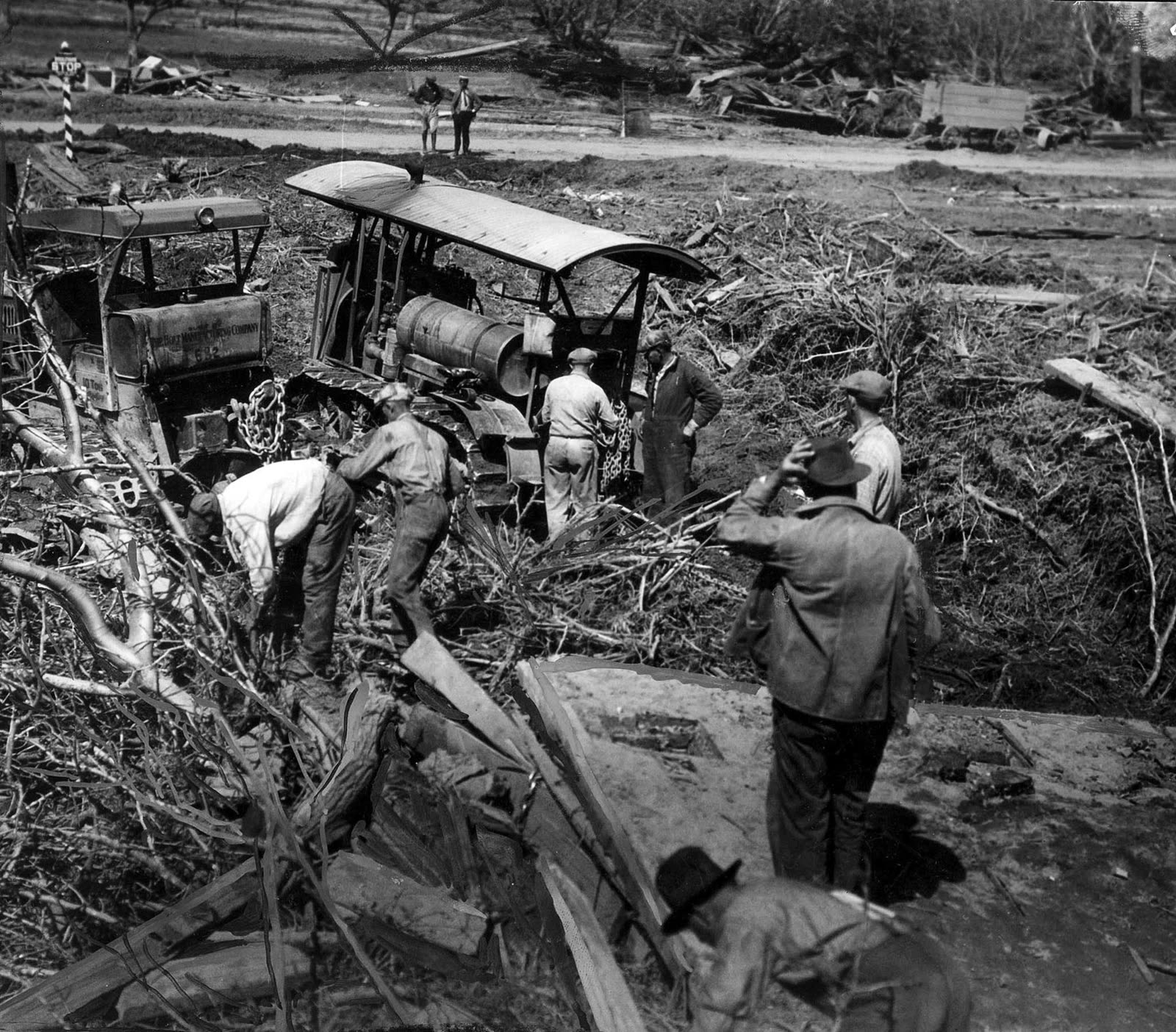
The archival photograph used for this article shows the aftermath at human scale: men in work clothes examining wreckage, a damaged vehicle caught among broken timber and debris, and a landscape reorganized by water.[4] It is not a diagram of failure. It is the social end of the mechanism. Every hidden assumption upstream ended as physical labor, search, recovery, homelessness, destroyed farmland, and missing names downstream.[3][4][5]
6. The policy lesson was independent review
California did not only memorialize the disaster. It changed the review system. The Department of Water Resources' dam-safety history states that the St. Francis failure directly led to the creation of the California Dam Safety Program on August 14, 1929.[3] The new legal framework gave the state responsibilities over examination and approval of existing dams, approval of plans and specifications, supervision of construction, and supervision of maintenance for jurisdictional dams.[3]
That reform is the best evidence for how officials interpreted the failure. The answer was not merely "build thicker walls" or "avoid one canyon." It was to create a standing institutional check between dam owners, designers, operators, and the public exposed downstream. The governor's commission had already framed its work as a public lesson, stressing that the investigation should be independent of those involved in the dam itself.[1] The 1929 program turned that principle into administrative capacity.[3]
The later national monument adds a different layer. The Forest Service planning document notes that the monument was designated in 2019, that the dam remains and wing wall continue to serve as reminders, and that public commemorations had gathered there on March 12 anniversaries.[6] Memory matters because infrastructure disasters fade when their ruins become scenery. The St. Francis site asks visitors to connect visible fragments to invisible systems: geology, pressure, review, authority, and public consequence.
The bounded conclusion
The St. Francis Dam did not fail because history needed a villain or because concrete is inherently fragile. It failed because a high dam and a first-full reservoir were placed in a canyon whose foundation conditions were not safely matched to the design; because uplift and seepage could undermine the apparent security of mass; because geologic uncertainty and structural stress interacted; and because public oversight had not yet forced independent review into the center of dam building.[1][2][3][4]
There is still a boundary around certainty. The exact initiating sequence has remained debated, and USGS is right to state that design, construction, geology, and reservoir level all remain part of the explanatory field.[4] But that uncertainty does not weaken the main historical lesson. It strengthens it. When the consequences of failure are catastrophic, uncertainty is not a reason to trust reputation. It is a reason to widen review, test assumptions, instrument the system, and treat geology as a load-bearing actor.
The flood of March 1928 made the failure visible. The deeper history is that the dam had already become unsafe in the relationship between water, rock, concrete, and unchecked authority. California's dam-safety regime was born from that realization.[3]
Sources
- Association of State Dam Safety Officials, "Report of the Commission Appointed Governor C.C. Young to Investigate the Causes Leading to the Failure of the St. Francis Dam" - metadata and abstract for the independent 1928 investigation, including authorship, year, and public-safety purpose.
- J. David Rogers and David J. McMahon, "Reassessment of the St. Francis Dam Failure," DamFailures.org - modern engineering-geology reassessment of first full filling, abutments, uplift pressure, arching stresses, seepage, and landslide mechanisms.
- California Department of Water Resources, "History of California Dam Safety" - summary of the disaster, state findings on poor construction and unstable geology, and the 1929 creation of California's dam-safety program.
- U.S. Geological Survey, "St Francis Dam Disaster" - historical summary, death-toll uncertainty, reservoir volume, downstream impact, public-domain image source, and Los Angeles Times archival photograph used as this article's cover image.
- California Office of Historic Preservation, "St. Francis Dam Disaster Site" - California Historical Landmark record with dam height, March 12, 1928 collapse, water volume, location, and death toll.
- U.S. Forest Service, Saint Francis Dam Disaster National Memorial and Monument - monument designation, 2019 legislation, floodplain distance, commemoration, site remains, and wider San Francisquito Canyon context.