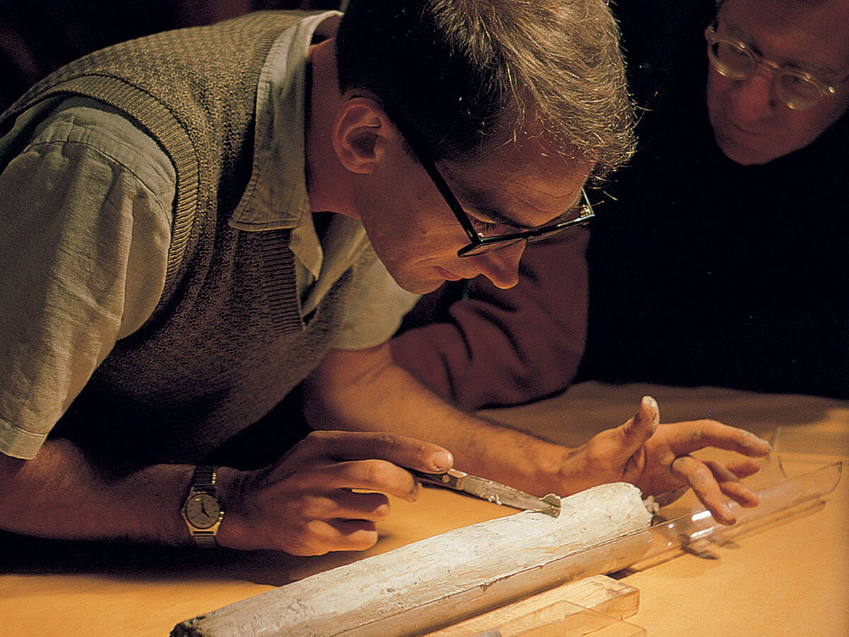
Project Mohole is remembered as a hole that was never drilled. That verdict is correct at the scale of its name: the American project did not cross the oceanic crust or recover rock from the mantle. But in March and April 1961, its ungainly drillship CUSS I did something on which every later deep-ocean coring program depended. It held position in nearly 12,000 feet of Pacific water, lowered a drill string through the moving sea, penetrated the seabed, and brought back sediment and basalt.[1][2]
Five years later, Congress refused further money. No full-scale Mohole vessel had been built, the final site had not been drilled, and the project office was heading toward closure.[3][4][5] The tempting lesson is that the engineering failed. The evidence points to a more useful distinction. Phase I solved a tightly bounded control problem at sea. The larger program then failed to build an equally clear control system on land—one that could keep scientific purpose, engineering scope, contract authority, cost, and political consent moving together.
This is not a story in which one clever machine was good and bureaucracy was simply bad. The deep hole genuinely posed harder engineering problems than the test. Nor did one organization chart mechanically cause Congress to act. The causal chain is narrower: a successful experiment established that deep-water drilling was possible; scaling it changed both the technical object and the institution responsible for it; divided authority made the next deliverable unstable; unstable scope made cost and schedule harder to defend; and Congress finally removed the appropriation. The method survived because it could be separated from the failed total project.
The shortest route down began with two miles of water
The Mohorovičić discontinuity, or Moho, is not a visible underground shelf. It was inferred from the abrupt change in seismic-wave velocities between Earth’s crust and the mantle below. By the 1950s, researchers knew that continental crust was too thick for a practical attempt to reach the boundary with the drilling technology then available. Oceanic crust offered a shorter rock column, but only after a ship crossed miles of water and kept a drill string on one point of the seafloor.[2][3]
That inversion made Project Mohole audacious: the ocean was both the shortcut and the main obstacle. A land rig begins with a fixed platform. A drillship heaves, rolls, drifts with wind, and is pushed by currents that can change with depth. Anchoring in extremely deep water was not a convenient answer. If the vessel moved too far, thousands of feet of pipe could bend, fatigue, or fail before the bit did useful work.
The 1961 program therefore did not pretend to be the mantle attempt in miniature. It was a sequence of experiments off La Jolla, California, and then near Guadalupe Island, Mexico. Its governing question was more basic: can a floating vessel maintain enough control to drill and recover cores in genuinely deep water? The National Research Council’s contemporary report devoted separate sections to ship motion, drill-string vibration, position sensing, sonar, steering screws, bits, casing, core handling, weather, and currents. That table of contents reveals the project’s real unit of success. It was not “depth” alone; it was a coordinated system.[1]
Phase I closed the loop
At Guadalupe, electronic position sensing told pilots how CUSS I was moving relative to the hole. Four omnidirectional propellers let them counter that motion from a central console. The 1961 NSF annual report described a maximum displacement of about 360 feet in 12,000 feet of water—three percent of the water depth—even with winds around 25 miles per hour and waves reaching 12 feet.[2]
The numbers sound loose if imagined on land. At sea, they marked a breakthrough. The causal loop ran from reference signals to human operators, from operators to propellers, and from the vessel through the drill string to the bit. Position did not mean making the ship motionless. It meant sensing error quickly enough, then applying force continuously enough, to keep the pipe within a safe working envelope.
Drilling added a second feedback problem. The crew had to recognize when a bit hanging beneath miles of water touched bottom, manage the weight placed on it, circulate water down the pipe to clear cuttings, and distinguish ship motion from dangerous vibration. The NSF report recorded no observable pipe whip at 40 revolutions per minute and no observable vertical drill-pipe vibration from the vessel’s heave during the test. Those observations did not certify a future mantle hole. They showed that familiar rotary drilling could be adapted without the suspended pipe behaving as an uncontrollable pendulum.[2]
The result was physical. At Guadalupe, five holes were drilled through 11,700 feet of water; the deepest reached 601 feet beneath the seabed. Beneath roughly 560 feet of sediment, the bit entered basalt and penetrated about 41 feet of the oceanic crust’s seismic “second layer.” The expedition also recorded a temperature profile in the hole and current measurements at several depths.[2] William Riedel, shown in the cover photograph, could bend over a core that had traveled from below a place where no fixed platform existed.[7]
Phase I worked because its promise was testable. It had an existing vessel, a defined operating season, observable failure conditions, and artifacts that could be inspected. A ship either held station closely enough or it did not. Pipe either reached the bottom and returned usable material or it did not. The experimental boundary made decisions legible.
Scaling changed the object
After 1961, “continue Mohole” could mean several different things. It could mean building the heavy-duty platform required for one ultradeep attempt. It could mean adding intermediate drilling to learn more about ocean sediments and crust before committing to the mantle. It could mean developing a general scientific facility whose value did not depend on a single spectacular endpoint. Each version implied a different ship, program, cost, schedule, and balance between scientists and engineers.[3]
The institution also changed. The informal American Miscellaneous Society had generated the idea, while the National Academy of Sciences gave Phase I a formal home and scientific leadership. Once the program became a major federal construction and contracting exercise, the National Science Foundation sought direct managerial control. In 1962, after a contentious competition, NSF contracted with the engineering and construction firm Brown & Root for development work.[3]
This solved one accountability problem and opened another. NSF needed a prime contractor capable of producing budgets, designs, schedules, and hardware for a large public project. Scientists feared that the apparatus for building the vessel could become detached from the reason for building it. The National Academies’ later administrative history describes authority split among a managing coordinator, NSF administrators, an in-house science coordinator, Academy advisers, and a policy committee. It calls the resulting arrangement unworkable, while also identifying technical barriers, cost overruns, personality conflict, and disagreement about phasing.[3]
That retrospective judgment should not be mistaken for a laboratory proof. Organizational failure rarely has one measurable cause. Yet the mechanism is visible. When nobody could settle which version of Mohole came next, engineering estimates answered a moving question. When scientific advice did not map cleanly onto contract authority, changing the science did not reliably change the build. When managers could not present a stable intermediate result, legislators were asked to fund an expensive trajectory rather than the next bounded proof.
The contrast with 1961 is sharp. At sea, error had a reference point: the location of the hole. In the scaled program, “off course” depended on which objective—mantle sample, crustal survey, drilling technology, or scientific facility—was treated as controlling.
Congress broke the project apart
By August 24, 1966, the decision became explicit. In the Congressional Record, Senator Warren Magnuson said that denying additional funds “in effect terminates the project” and directed NSF to close it out while deciding which advanced components might still be worth completing.[4] The National Archives dates formal termination to October 1, 1966, by failure of appropriation; its Project Mohole record group contains the administrative files, contractor material, reports, and photographs left by that ending.[5]
Congress did not rule that deep-ocean drilling was impossible. It stopped paying for this organizational package. That distinction explains why Mohole’s most useful parts escaped. The 1961 expedition had already turned dynamic positioning from an enabling idea into an observed operating method. It had demonstrated that cores could be recovered from beneath deep water. It had also produced specimens that were valuable independently of whether anyone ever reached the mantle.
A less monolithic successor emerged alongside Mohole’s decline. Universities formed the Joint Oceanographic Institutions for Deep Earth Sampling, or JOIDES, to provide collective scientific guidance. Congress supplied money for an ocean-sediment program in 1966; Scripps became the operator; and the Glomar Challenger began the Deep Sea Drilling Project in 1968.[3][6] This program did not need to inherit Mohole’s all-or-nothing promise. It could drill many holes, return many cores, and let each cruise add evidence about seafloor spreading, plate tectonics, ocean history, and Earth’s climate.
Calling that outcome a simple triumph rescued from a fiasco would go too far. Mohole’s named objective remained unmet, and its institutional collapse consumed public money and scientific attention. But the successor’s structure matters. Scientific ocean drilling became repeatable: not one heroic descent toward a final boundary, but a platform, a consortium, a sequence of sites, and a growing archive.[3][6]
The first cores are still producing results
The strongest rebuttal to the idea that Phase I was merely theatrical arrived not in 1961 but in 2026. Margaret Morris and colleagues removed the Guadalupe cores from refrigerated repository racks and examined them with X-ray fluorescence, magnetic susceptibility, and high-resolution line-scan imaging. Their measurements, collected at roughly one-centimeter resolution, could be compared with analyses made when the material was fresh.[8]
The cores were not pristine. The researchers noted disturbance and uncertainty in depth, and some physical properties can change during long storage. Even so, the new geochemical measurements largely validated and extended the earlier work. The authors found that decades of storage had not erased the cores’ usable chemical signature, and that modern scans could sharpen boundaries in the recovered sediment.[8]
That afterlife clarifies what Project Mohole actually made. It did not make a hole to the mantle. It made a method for holding a ship over a point no anchor could conveniently fix; a practical relationship among sensors, pilots, propellers, pipe, and seabed; a set of cores that remained available to better instruments; and a cautionary example of what happens when a project scales faster than its authority can be defined.
The title “failed project” is therefore necessary but incomplete. Mohole failed as an integrated promise between 1961 and 1966. Its separable outputs succeeded because they had their own evidence of value. The drillship had a reference point. The cores had repository labels. The later program had repeatable cruises. What drifted was the part that could not specify, with equal precision, who controlled the next decision and what the next success had to be.
Sources
- National Research Council, Experimental Drilling in Deep Water at La Jolla and Guadalupe Sites (1961) — primary project report covering the operating narrative, dynamic positioning, drilling, core handling, scientific work, weather, conclusions, and costs.
- National Science Foundation, Eleventh Annual Report of the National Science Foundation (1961) — contemporary account of the Guadalupe holes, water and drilling depths, basalt recovery, in-hole measurements, currents, and dynamic-positioning performance.
- National Research Council, “Ocean Sciences at the National Science Foundation: An Administrative History,” in 50 Years of Ocean Discovery (2000) — retrospective institutional analysis of Mohole’s contracting, divided authority, cancellation, and the formation of JOIDES and the Deep Sea Drilling Project.
- U.S. Congress, Congressional Record, August 24, 1966 — Senate statement that denial of additional funds terminated Project Mohole and instructions for an orderly closeout.
- U.S. National Archives, “Records of the National Science Foundation,” Record Group 307.9 — archival description of Project Mohole’s 1962–1968 records and its October 1, 1966 termination after the appropriation failed.
- International Ocean Discovery Program, “History” — institutional chronology connecting CUSS I’s 1961 dynamic positioning to the Deep Sea Drilling Project and later international scientific-ocean-drilling programs.
- Scripps Institution of Oceanography, “Scripps History” — institutional source page for the archival photograph of William Riedel examining a Project Mohole core in 1961.
- Margaret A. Morris et al., “Project Mohole Results Enhanced With Modern XRF Core Scanning and Imaging,” Geochemistry, Geophysics, Geosystems 27 (2026) — modern remeasurement of the Guadalupe cores and comparison with analyses made up to 64 years earlier.