
Mount St. Helens is often remembered through a before-and-after silhouette: the near-perfect cone that lost its top on May 18, 1980. That memory is accurate but incomplete. The event's historical force lies in a much tighter clock. A Sunday morning that appeared stable at 7:00 a.m. changed after an 8:32 a.m. earthquake, a collapsing north flank, a sideways blast, and an ash column that made the eruption legible far beyond the mountain itself.[3]
The archival footage below is valuable because it was not filmed from a tourist overlook after the story had already become settled. USGS geologist Don Swanson filmed the eruption from a fixed-wing surveillance aircraft later that morning, using a Bell & Howell hand-wound 16mm movie camera while the volcano was still in violent motion.[2] The video therefore belongs to a narrow category of disaster record: it is both evidence gathered during an emergency and a visual artifact shaped by scientific fieldwork.
That double identity matters. The camera does not give us the dramatic opening instant of the flank collapse. By the time Swanson is filming, the eruption has already crossed the threshold from warning to catastrophe. What the footage preserves instead is the sustained behavior of the event: rising ash, ground-hugging pyroclastic density currents, and the scale problem faced by observers trying to convert a living disaster into usable knowledge.[2][4]
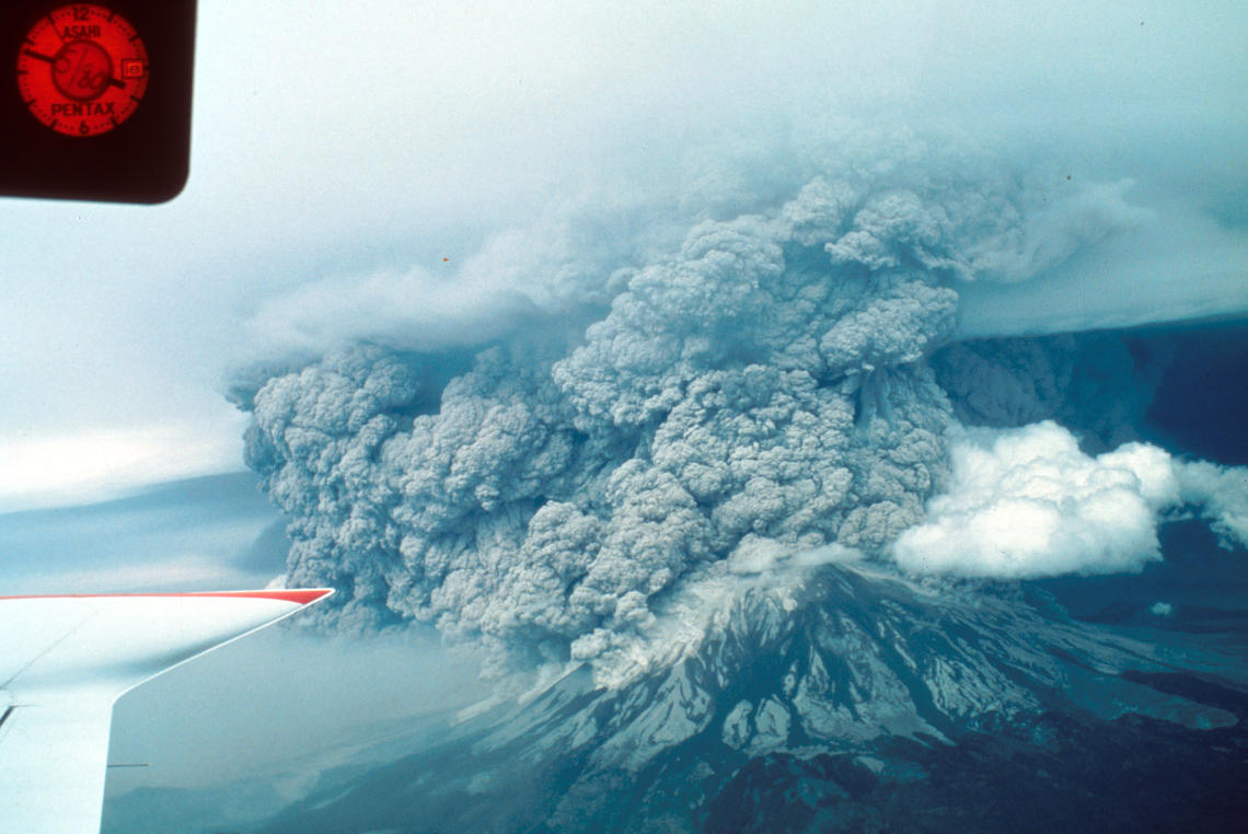
Image context: the cover image is a public-domain USGS photograph by J. G. Rosenbaum, described by USGS as showing the May 18 eruption from the southwest, with pyroclastic density currents spilling over the crater rim.[5] It is included because this article is about the historical value of archival seeing: aircraft, cameras, and scientific observation turned the eruption from a local catastrophe into a record that could be studied, taught, and remembered.
Historical context: the warning signs were real, but the final sequence was brutally compressed
Mount St. Helens had not been quiet in the spring of 1980. USGS's later fact sheet describes small earthquakes beginning on March 16, followed by steam explosions, deformation, and a growing bulge on the mountain's north flank.[4] The danger was not invisible. Scientists, officials, and residents understood that the volcano had reawakened, even if the exact mode and timing of a major eruption remained beyond precise prediction.
That uncertainty is the core historical tension. The volcano was being monitored, but monitoring did not mean control. USGS's account of the climactic eruption notes that David A. Johnston, on duty at an observation post about 6 miles north of the volcano, radioed laser-measurement results around 7:00 a.m. on May 18. Those measurements did not reveal an obvious new warning that the final collapse was imminent.[3] About an hour and a half later, a magnitude 5.1 earthquake occurred roughly 1 mile beneath the volcano, and the unstable north flank began to fail.[3]
The most important word in that sequence is "flank." The eruption is easy to misremember as a vertical explosion from a summit crater. The disaster began when the bulged north side slid away, removing pressure and letting the volcano erupt laterally.[3][4] That sideways movement sent hot gas, steam, and rock debris across the landscape with extraordinary speed, while the debris avalanche and lahars remade drainage systems below.[3][4]
For history, this makes Mount St. Helens a case study in how catastrophe can be both anticipated and still temporally shocking. The months of unrest created a warning regime. The final minutes defeated ordinary intuition. People could understand "volcano" and still not picture a mountain failing sideways across forests, roads, lakes, and monitoring posts. The historical lesson is not that scientists missed an obvious signal. It is that the system had entered a danger zone where the decisive transformation could happen faster than public imagination, policy boundaries, and human escape routes could adapt.
The consequences were measured in lives, terrain, and infrastructure. USGS records 57 deaths from the eruption and describes major destruction to homes, bridges, railways, and highways.[3][4] Yet the event also changed the history of volcano science itself. The eruption produced an immense archive of observation: still photographs, field notes, instrument records, aerial surveys, and film. The 2022 USGS data release explains that historical video from 1980-1982 includes footage from ground campaigns, aircraft, and time-lapse stations, capturing dome growth, ash emissions, rockslides, and pyroclastic flows.[4] The archive was not a supplement to the event. It became part of the event's afterlife.
Video provenance
The embedded video is "Footage of the 1980 Mount St. Helens Eruption," published on YouTube by the Smithsonian Channel.[1] The archival footage itself is described in USGS's media record as Don Swanson's film of the eruption from about 9:30 a.m. to 12:30 p.m. on May 18, shot from a surveillance aircraft and later digitized into a compiled video.[2] That provenance is the reason the video is useful here. It is not a simulation, animation, or retrospective montage trying to explain the eruption from a safe distance. It is film made from inside the observation effort while the event was still unfolding.
Close reading: what the airborne camera makes visible
The first thing to watch for is scale. A still photograph can freeze the eruption into a spectacular composition. Moving footage makes the ash column and ground-hugging currents feel procedural. They do not simply appear. They build, spill, roll, and continue. That distinction matters historically because the disaster was not a single blast followed by aftermath. It was a sequence of linked processes: flank collapse, lateral blast, eruption column, pyroclastic density currents, debris movement, and ash distribution.[2][3][4]
The airborne viewpoint also changes the moral geometry of the scene. From the ground, a disaster often appears as a wall, a sound, a darkness, or a road that suddenly cannot be used. From the aircraft, the eruption becomes a system with edges, flows, and changing fronts. The camera helps turn terror into evidence, but it does so without making the event feel tame. If anything, the plane's distance clarifies how little human scale matters once the volcano's side has failed.
Around the footage's sustained views of the plume and crater, the viewer can see why "eruption" is too small a word for the whole event.[1][2] The column rises, but the more unsettling movement is lateral and downward. Pyroclastic density currents hug the ground and spill over the crater rim, the same behavior noted in the USGS description of Rosenbaum's aerial photograph.[5] The mountain is not only venting. It is exporting itself into the surrounding landscape.
The footage also helps correct a common disaster-memory habit: the tendency to locate significance in the most cinematic instant. Mount St. Helens did have an opening rupture, and the initial landslide and lateral blast are central to understanding why May 18 became so destructive.[3][4] But the archival film asks the viewer to stay with duration. Scientific seeing required endurance. Swanson's camera documents hours, not seconds. That is why the record remains useful: it captures the volcano as a process that investigators could later revisit frame by frame.[2][4]
Another detail worth noticing is the technological modesty of the archive. A hand-wound 16mm camera in a fixed-wing aircraft is not the frictionless eye of today's satellite feeds and drone surveys.[2] It required proximity, timing, physical handling, and risk. That is part of the video's historical texture. The record exists because people and institutions had already built a monitoring culture around the volcano, and because a scientist in an aircraft could still become a camera operator when the mountain forced the issue.
That does not mean the footage explains everything by itself. It does not reconstruct the whole warning debate, the evacuation boundary problem, the individual stories of those who died, or the later politics of creating the Mount St. Helens National Volcanic Monument. Written sources have to do that work.[3][4] But the film supplies something prose cannot: a sense of an event large enough that even an aerial camera seems to be chasing it rather than mastering it.
Legacy: the archive made the disaster teachable without making it simple
Mount St. Helens became a landmark in U.S. disaster history because it sat at the intersection of natural process, scientific monitoring, public risk, and media memory. It was the deadliest and most economically destructive volcanic eruption in the history of the contiguous United States, but it was also a turning point in how Americans saw volcano hazards as ongoing systems rather than remote geologic abstractions.[3][4]
The archival footage keeps that lesson honest. It resists the clean shape of a lesson plan. The eruption did not become meaningful only because a summit vanished. It became meaningful because months of warning narrowed into minutes of irreversible failure, then widened again into years of documentation, field study, and public interpretation.[2][3][4] That is why the video remains powerful in 2026. It shows a catastrophe being converted into knowledge while the ash is still moving.
The best way to read the film, then, is not as a substitute for the written history. It is the pressure point in the middle of it. Before the video, we need the chronology: March unrest, May 18 morning measurements, the 8:32 a.m. earthquake, the flank collapse, the lateral blast.[3][4] After the video, we need the archive: digitized film, still photographs, data releases, and public-domain records that made the eruption available for future science and memory.[2][4][5] The footage sits between those two tasks. It is what history looks like when the event is still happening and someone is already trying to preserve it.
Sources
- Smithsonian Channel, "Footage of the 1980 Mount St. Helens Eruption," YouTube video.
- U.S. Geological Survey, "Mount St. Helens in eruption, May 18, 1980" - media record describing Don Swanson's airborne 16mm footage and digitization.
- U.S. Geological Survey, "The Climactic Eruption of May 18, 1980" - chronology of the 8:32 a.m. earthquake, flank collapse, and immediate effects.
- U.S. Geological Survey, "Historical video footage of Mount St. Helens volcano, Washington, 1980-1982" - data release overview of digitized film records from ground, air, and time-lapse stations.
- U.S. Geological Survey, "Eruption of Mount St. Helens May 19, 1980" - public-domain J. G. Rosenbaum aerial photograph used as the article image.