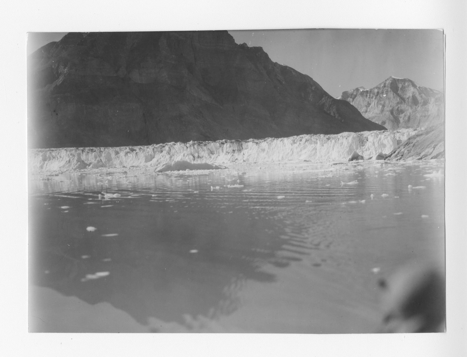
On 31 July 1931, Louise Arner Boyd photographed Nordenskiöld Glacier from a motorboat near the inner end of Greenland's Kejser Franz Joseph Fjord. Her accompanying note preserved the direction of the view, west-southwest, and identified a landing place on the north shore. It even referred to other photographs showing that shore in detail.[1]
The instructions offer an entry into Boyd's working life. During four East Greenland expeditions between 1931 and 1938, the Californian traveller developed a role as expedition leader and photographer.[2] How did images taken on journeys she paid for become evidence that mapmakers could use?
A fortune bought the passage
Boyd grew up in a wealthy California family and attended private schools, but never went to college. Her brothers died young; her mother died in 1919, her father in 1920. With her immediate family gone, travel became central to her life. A visit to Spitsbergen in 1924 drew her towards the Arctic.[2]
Her early expeditions belonged to the world of expensive leisure. In 1926, she chartered the Norwegian vessel Hobby and took friends north to hunt polar bears. The surviving film records trophy kills alongside explanations of Arctic ice. When she returned in 1928, another hunting voyage became a search for the missing explorer Roald Amundsen. Boyd offered the ship and her services; the unsuccessful search brought her into contact with polar researchers.[3]
This beginning matters because her later work did not emerge from a university appointment or a scientific grant. Private wealth gave her unusual freedom to commission a voyage and decide what it would attempt. It could purchase equipment and other people's expertise. Establishing what she herself contributed requires looking more closely at the photographs and the arrangements around them.
The information outside the frame
Boyd called the 1931 journey a photographic reconnaissance. The American Geographical Society Library's reconstruction of that voyage connects her photographs to a manuscript map and to annotations on the backs of the prints. It describes the trip as preparation for a more comprehensive survey in 1933.[5]
A mountain profile changes as the boat moves. Without a known viewpoint, a later reader must guess how its peaks and shorelines fit together. Boyd's note preserved that context: direction, landing place and cross-references survive alongside the view.[1]
The improvement was deliberate. In their archival study, Elisabeth Isaksson and Anka Ryall describe advice from the Society's director, Isaiah Bowman, about photographic subjects and their supporting information. His correspondence with Boyd in March 1932 praised the results of her latest work. They also recover the physical labour from camera carrier Erik Bratseth's diary: bulky equipment, glass plates and developing supplies had to be taken into the terrain.[4]
A useful viewpoint had to be reached with the apparatus. The resulting print could conceal the effort of getting photographer and equipment into position.
The map was a collaborative product
Raye R. Platt's biographical account in the unfinished Encyclopedia Arctica gives a concrete result. In 1931, Boyd took more than 200 photographs from 50 stations of the connection between Kjerulf and Dickson fjords. The American Geographical Society subsequently used the material to construct a detailed topographic map.[6]
On the 1933 expedition, the personnel included topographer O. M. Miller, assistant topographer Walter A. Wood, geologists and a botanist. Platt records surveys made with a Wild phototheodolite, an instrument combining photography with surveying measurements. After the expedition, Wood carried out the plotting in Zurich on equipment Boyd rented.[6]
Boyd supplied money and photographic work; specialists measured, interpreted and plotted. Returning to port left substantial work still to do.
In 1937, Platt credits Boyd with the camera work on surveys of Tyroler Valley and beside Narwhal Glacier. In 1938, her coverage of the Orientering Islands supported a map produced after the expedition returned.[6]
Publication brought the photographs beyond the expedition circle. The Fiord Region of East Greenland, drawing on the 1931 and 1933 journeys, contained 350 photographs.[3] Their scale within the volume made the visual record a substantial part of what readers encountered, giving the camera's work a presence that an itinerary alone could never supply.
Authority had to be exercised
Paying the bills gave Boyd power, but it did not make her authority socially effortless. Isaksson and Ryall cite her 1939 radio interview describing resistance both to her sex and to her lack of formal scientific qualifications. Their research also identifies contracts requiring expedition researchers to accept her control over dissemination of the results, including an agreement with J. Harlen Bretz in 1933.[4]
The contracts show her organizing how privately financed research would become public knowledge. Patronage, management and fieldwork were connected responsibilities.
There was a visible change in the moving images, too. National Archives specialist Audrey Amidon observes that Boyd's later footage lacks the edited educational framing of her earlier films. As large-format photography became part of the mapping work, she continued filming the landscape without assembling the same kind of narrated adventure.[7] The surviving record registers a change in what she was trying to bring home.
A record that outlasted the voyage
The information acquired another purpose when war intervened. The United States government asked Boyd to delay publication of her later Greenland volume, concerned about the detailed material becoming available to potential enemies. She shared and documented her work for the government.[7] The Coast of Northeast Greenland finally appeared in 1948.[2]
The material also had to survive changes of ownership. In 1974, the San Rafael Elks, who had purchased Boyd's former estate, donated 150 reels of her film to the National Archives. The nitrate originals were copied to safety film.[7] Preservation extended the working life of images made decades earlier.
The university library's digital reconstruction performs a different kind of recovery. It lets a reader move between Boyd's camera positions, photographs and manuscript map.[5] That arrangement restores relationships which a gallery of attractive Arctic views would leave obscure. It makes the observations inspectable as a group: readers can follow the places where she stopped, then examine what she recorded from them. The supporting paperwork remains part of the visual record.
The glacier photograph preserves a view and the means of locating it. Boyd brought back both, leaving other people a place from which to begin their own work.
Sources
- Louise Arner Boyd, Nordenskiöld Glacier photograph, 31 July 1931, lb002504. American Geographical Society Library, UWM Libraries.
- California Academy of Sciences, “Boyd (Louise A.) papers, 1887–1972,” collection MSS-064. Online Archive of California: biographical chronology and publication history.
- Audrey Amidon, “Women of the Polar Archives: The Films and Stories of Marie Peary Stafford and Louise Boyd,” National Archives, Prologue, Summer 2010: hunting voyages and the Amundsen search.
- Elisabeth Isaksson and Anka Ryall, “The Queen of the Arctic: Louise Arner Boyd,” Polar Research 42 (2023).
- American Geographical Society Library, “Louise A. Boyd's Exploration of Kjerulf and Dicksons Fjords, 1931.” University of Wisconsin–Milwaukee: photographs, viewpoint locations and manuscript-map annotations.
- Raye R. Platt, “Louise Arner Boyd,” Encyclopedia Arctica, volume 15, Dartmouth Libraries.
- Audrey Amidon, “Filming the Far North: Louise Arner Boyd's Arctic Travels,” National Archives, The Unwritten Record, 18 March 2024: changes in filmmaking and wartime use of Boyd's records.