One fishing boat rode out the wave inside Lituya Bay. Another was lifted across a spit and wrecked beyond it. A third sank near the entrance. In the same small Alaskan inlet, the disaster of July 9, 1958 produced three radically different journeys.[7]
The number that usually introduces this story is 1,720 feet, or about 524 meters: the extraordinary elevation reached by water on a hillside opposite a landslide.[6] Yet that number alone cannot explain what happened aboard the boats. To reconstruct the night, we have to follow the water from the head of the bay toward its mouth—and keep the survivors’ estimates separate from the marks left on land.
July 9: the danger begins inside the shelter
At about 10:16 p.m., a magnitude 7.8 earthquake struck southeastern Alaska. Howard Ulrich and his seven-year-old son were aboard the Edrie. Bill and Vivian Swanson occupied the Badger; the Wagners were aboard the Sunmore. The boats had taken shelter in Lituya Bay for the night.[2]
The earthquake released an enormous mass from the steep terrain at the bay’s head. The National Park Service puts the fallen material at roughly 40 million cubic yards. Its impact displaced water violently upward against the opposite slope and sent a destructive wave through the inlet.[3]
This sequence matters. A landslide can generate a tsunami by entering a body of water; it does not require a great section of ocean floor to rise beneath it. NOAA distinguishes such locally generated waves from tsunamis capable of transmitting destruction across an ocean basin.[4] The boats’ shelter from the open coast placed them inside the basin where the disturbance began.
The surrounding land then shaped what the water did. NASA’s account emphasizes the narrow bay and its U-shaped floor, which helped produce repeated surging from side to side.[6] The event would not consist of one clean crest passing through and leaving still water behind.
An anchor chain, a spit, an entrance
Ulrich’s account, preserved in geologist Don J. Miller’s 1960 USGS report, gives the closest view from the Edrie. Unable to free his anchor, Ulrich paid out the chain and started the engine. He estimated the approaching front at 50–75 feet high. As the boat rose, the chain broke. Water carried it toward the south shore, then back toward the bay’s center.[1]
His description includes an essential distinction: the wave broke on one side of Cenotaph Island but retained a smoother crest on the other. These were eyewitness observations during an emergency, not measurements from a gauge. Still, they preserve something a single maximum-height statistic erases: the shape of the wave varied across the bay.[1]
Near the entrance, the Badger took another route. It was swept across La Chaussee Spit and foundered outside the bay. Bill Swanson remembered looking down at trees as the boat was carried over them. He and Vivian escaped in their skiff and were rescued shortly after midnight. The Sunmore and the Wagners were lost.[2]
The contrast resists a tidy lesson about seamanship. These crews occupied different positions and encountered different combinations of water, shore, and debris. Surviving aboard a boat inside the bay and surviving the loss of a boat outside it were separate outcomes. The record does not let us turn either into a dependable maneuver that would have saved everyone.
For Ulrich, staying afloat was only the first stage. He reported steep, confused waves after the main surge, followed by floating timber obstructing the water. He eventually took the Edrie through the entrance at about 11 p.m.[1]
July 10: reading what the water left
Miller flew over Lituya Bay the following morning. The water was so thick with logs and ice that his aircraft could not land.[2] From the air, the disaster presented a different kind of evidence: a sharply bounded belt of destruction along the shores.
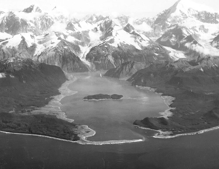
In Miller’s archival photograph, reproduced above, the pale ground follows the water’s edge beneath darker forest. The USGS identifies those light areas as terrain stripped by the wave. Near Fish Lake, the destruction extended as far as 3,600 feet inland from the high-tide shoreline.[7] Distance inland and elevation uphill describe different dimensions of the same event. A low shore allows water to travel across ground; a steep slope records its upward reach.
The photograph is powerful precisely because the wave has gone. It lets us compare the surviving landscape with the emptied margins around it. It cannot show the water’s speed or the instant a boat rose. For those moments, reconstruction depends on testimony. The picture and the accounts answer different questions; neither supplies a complete view by itself.
The highest destruction mark lay on the ridge opposite the slide. NASA identifies the 1,720-foot elevation there and notes that the affected forest remained distinguishable in satellite imagery more than sixty years later.[6] The event lasted minutes, but vegetation preserved its outline across generations of observers.
What the record height records
NOAA defines run-up as the highest elevation reached by water above a reference sea level. Its account of Lituya distinguishes the exceptional splash against the slope from the tsunami traveling through the bay.[4] The hillside maximum therefore cannot be assigned to every point along the wave’s route. Ulrich’s much lower estimate at his boat and the immense mark near Gilbert Inlet describe different places and different aspects of the event.
The early scientific language was careful, too. In their paper published on February 13, 1959, Don Tocher and Miller described a wave exceeding 1,700 feet and identified a rockslide as its possible cause. Their abstract also reported substantial horizontal movement on the Fairweather fault.[5]
That wording captures an investigation still separating observation from explanation. The elevation of damage, the displacement along a fault, and the mechanism that moved the water were related questions, but establishing one did not automatically settle the others. Reading the contemporary report preserves that sequence of discovery. It keeps later certainty from being silently inserted into the first observations.
The three boats bring the scale back to human experience. One crew remained aboard a working vessel; another needed a skiff and rescuers; the third left no surviving account. Their different fates explain why the height record is a beginning, not a complete reconstruction. Lituya Bay’s wave was shaped by the ground it struck—and the story we can tell is shaped by where people survived to describe it.
Sources
- Don J. Miller, Giant Waves in Lituya Bay, Alaska, USGS Professional Paper 354-C (1960), pp. 57–59: eyewitness accounts and the boats’ movements. PDF hosted by the Alaska Division of Geological & Geophysical Surveys.
- Ian Dickson, “60 years ago: The 1958 earthquake and Lituya Bay megatsunami,” Alaska Earthquake Center (July 13, 2018): crews, earthquake timing, rescue, and Miller’s first flight.
- National Park Service, “Landslides and Giant Waves,” Glacier Bay National Park & Preserve (updated June 5, 2018): the landslide’s estimated volume and local wave generation.
- NOAA National Centers for Environmental Information, “Introduction to Global Historical Tsunami Data”: landslide-generated tsunamis, the Lituya splash, and the definition of run-up.
- Don Tocher and Don J. Miller, “Field observations on effects of Alaska earthquake of 10 July 1958,” Science (February 13, 1959), USGS publication record and abstract. The title uses the earthquake’s UTC date.
- Adam Voiland, “Lituya Bay’s Apocalyptic Wave,” NASA Earth Observatory (November 23, 2020): bay geometry, the maximum run-up, and the surviving forest boundary.
- Don J. Miller, “Lituya Bay, 1958,” USGS photographic archive: aerial photograph, shoreline damage, inland reach, and the three boats’ different paths.