The Johnstown Flood is often told in one blunt sentence: a private dam failed on May 31, 1889, and a wall of water destroyed a Pennsylvania industrial town.[1][4] That sentence is true, but it misses the chain that made the flood historically distinct. Rain mattered, but rain alone did not build the catastrophe. The sharper story runs through a sequence: years of neglect and damaging alterations at the South Fork Dam, a narrow valley lined with towns and railroad infrastructure, the wave's acceleration through communities upriver from Johnstown, and finally the Stone Bridge, where debris piled up, survivors were trapped, and fire turned the flood from a violent passage into an hours-long inferno.[1][2][3][4][5]
Read that way, Johnstown becomes more than a nineteenth-century disaster anecdote. It becomes a chronicle of how natural force and human systems locked together. The flood was not simply "too much water." It was water routed through bad engineering decisions, settlement patterns, industrial geography, and a relief response large enough to become one of the early major tests of the American Red Cross.[1][2][5]
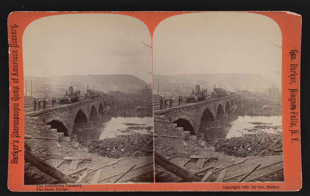
The lead image shows the Stone Bridge after the flood, with men standing above a dense mass of wreckage jammed beneath the arches.[6] It belongs here because the bridge was the moment when the wave changed character. Upstream, the flood was a moving force. At Johnstown, once debris lodged at the bridge, the disaster became something worse: a trap.
Timeline anchors
- 1830s-1853: Pennsylvania built the South Fork Dam and Western Reservoir as part of the Main Line Canal system.[1]
- 1879: The South Fork Fishing and Hunting Club acquired the dam and lake for a private resort and kept operating with altered, weakened infrastructure.[1][2]
- May 31, 1889, around 3:10 p.m.: The South Fork Dam failed after heavy rain.[1][4]
- May 31, 1889, 4:07 p.m.: Floodwaters reached Johnstown in under an hour.[1][4]
- On the evening of May 31, debris piled against the Stone Bridge and later caught fire, trapping survivors in the wreckage.[5][6]
- In the days after the flood, Clara Barton and the American Red Cross entered the relief effort, and cleanup stretched on for years.[2][5]
These anchors matter because they keep the event from collapsing into one instant. The dam break was the trigger, not the whole disaster.
Before the break: the disaster was sitting above the valley for years
The National Park Service account of the South Fork Dam makes the prehistory painfully clear. The dam had originally been built for canal operations, but after the canal system declined it passed into hands less interested in water control than in recreation.[1] By the late 1870s and 1880s, the South Fork Fishing and Hunting Club had turned the reservoir into Lake Conemaugh, a private summer retreat for wealthy members from Pittsburgh.[1][2]
The structural details matter because they explain why the flood later looked so sudden while being years in the making. According to the Park Service, the club never replaced the dam's discharge pipes, lowered the crest to widen the road across it, and installed fish screens that obstructed the spillway.[1] The NPS teaching page adds the essential judgment: the dam had been repaired without the benefit of an engineer, even though it held back one of the largest artificial lakes in the nation.[2] By 1889, the structure stood above the valley as a recreational amenity for one social world and a standing risk for another.
This is the first reason the Johnstown Flood has such enduring force in American memory. People in the valley did not drown because nature produced an unimaginable event out of nowhere. They lived below a known, altered piece of infrastructure that had already failed before and was still not treated with the care its position required.[1][2]
The valley run: once the dam failed, geography multiplied the damage
When the dam finally gave way around 3:10 p.m., the release was enormous. The South Fork Dam page estimates 20 million tons of water behind the structure; PBS's Building Big summary describes the resulting surge as roughly 35 to 40 feet high at its crest and moving at an average speed of about 40 miles per hour on its trip to Johnstown.[1][4] Those numbers matter, but the route matters more.
The Path of the Flood page lays out the sequence of communities in the water's path: South Fork, Mineral Point, East Conemaugh, Woodvale, and then Johnstown itself.[3] This was not empty countryside. It was a worked industrial corridor. South Fork sat nearest the dam; Mineral Point and East Conemaugh were strung along the valley and railroad line; Woodvale included mill property and workers' housing; Johnstown sat on low ground at the junction of the Little Conemaugh and Stony Creek, with a population of about 10,000.[3]
That geography turned the flood into a collection machine. The wave did not arrive as clean water. It picked up houses, trees, railcars, mill materials, telegraph poles, livestock, and human bodies as it moved.[4][5] By the time it reached Johnstown at 4:07 p.m., it was not only fast water but a dense, weaponized mass of the valley itself.[1][4]
That point is crucial for the article's main claim. The Johnstown Flood was catastrophic not just because a reservoir emptied. It was catastrophic because a private infrastructure failure released force into a narrow industrial corridor that fed the wave more material with every minute.
The Stone Bridge: this is where the flood turned into a trap
The Pennsylvania Center for the Book description gives the event its most horrifying second act. After the wave tore through the town, debris jammed at Johnstown's stone railroad bridge, creating a mound roughly 30 feet high.[5] Some survivors reached that pile and climbed onto it because it looked, for a moment, like the one thing in the city not moving away. Then the wreckage caught fire.[5]
This is the scene the lead image preserves in aftermath form. The Library of Congress page describes the photograph simply as men on the bridge with machinery and surrounding debris in and around the water.[6] That spare description is enough. It shows how the bridge converted current into compression. A town that had already been smashed apart was suddenly reassembled into one lethal knot.
The Stone Bridge matters historically because it exposes the flood's full mixed nature. Water alone did not create that mound. The jam required architecture, rail infrastructure, timber, houses, and industrial debris. Fire then entered the story, turning a flood into a furnace. What killed people in Johnstown was not one clean natural force but a sequence of forces made to cooperate by the built environment.[5][6]
That is why the bridge deserves to sit near the center of the chronicle rather than as a grim detail near the end. It was the place where the disaster became legible as systems failure.
After the wave: national relief began almost immediately, and the cleanup lasted years
The flood's destruction was measured quickly, but not resolved quickly. The NPS teaching page notes 2,209 known deaths, roughly 1,600 homes lost, and about $17 million in property damage.[1][2] Contact with Johnstown was cut off early, rumors spread, and the first national reports oscillated between exaggeration and disbelief.[2] Even once the scale was understood, the place could not simply be reset. The same NPS account says cleanup lasted five years, and bodies were found months and even years after the flood.[2]
This is where Johnstown enters a second American history: disaster relief. Contemporary and retrospective accounts of the catastrophe emphasize that Clara Barton arrived within days with the American Red Cross, bringing doctors, nurses, hospital tents, food, clothing, and temporary shelter.[2][5] That response did not erase the damage, but it helped define what large-scale civilian relief could look like after an industrial disaster. Johnstown therefore belongs not only to the history of engineering negligence, but also to the history of emergency administration.
Why the catastrophe still matters
The strongest reading of Johnstown is narrower and harsher than the familiar morality play about greedy elites and unfortunate weather. The catastrophe became national because several systems failed in sequence and then interacted: reservoir management, engineering maintenance, valley settlement, industrial concentration, and emergency communication.[1][2][3][4][5] The flood wave itself was terrible. The disaster that Americans remembered was bigger than the wave.
That is why the Stone Bridge image remains so effective.[6] It does not show only destruction. It shows aggregation: a society's houses, machines, and transport lines crushed into one mass by a force those same systems helped magnify. Johnstown still matters because it shows how quickly a "natural disaster" can become a human-made regime of entrapment once infrastructure, geography, and complacency line up in the wrong order.
Sources
- National Park Service, "The South Fork Dam" - history of the dam, its damaging alterations, reservoir scale, and the timing of the 1889 failure.
- National Park Service, "Run for Your Lives! The Johnstown Flood of 1889" - teaching page with background on the club, the flood's casualties and damage, cleanup duration, and relief context.
- National Park Service, "Path of the Flood" - the sequence of towns in the flood corridor and Johnstown's industrial-valley geography.
- PBS, Building Big, "The South Fork Dam" - overview of the dam collapse and flood-wave height and speed on the run to Johnstown.
- Pennsylvania Center for the Book, "The Great Johnstown Flood" - account of the Stone Bridge debris pile, the fire, and the scale of the wreckage.
- Library of Congress, "The Johnstown calamity. The stone bridge" - source page for the 1889 stereograph used as the article image.