The Johnstown Flood is often remembered as a terrible weather event: days of rain, a dam break, a wall of water, and one of the deadliest civilian disasters in nineteenth-century America.[1][3] The rain mattered, but that summary is still too passive. Rain alone did not produce 2,209 deaths, erase 1,600 homes, and leave a debris field so dense that it caught fire at the Stone Bridge.[1][3] The sharper historical question is what had to line up before weather could do damage on that scale.
The answer is a chain rather than a single cause. An older state reservoir dam first became obsolete infrastructure. It was then converted into a private leisure lake. Key control features were removed or allowed to disappear. The crest was lowered, the spillway obstructed, and repeated warnings about repair quality never produced a full redesign.[1][2] When the storm of May 31, 1889 arrived, the water had very little margin left. Once the dam failed, the 14-mile run to Johnstown and the town's own choke points turned released water into wreckage, impact, and fire.[1][3]
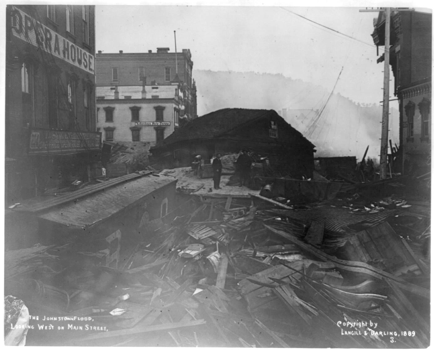
Image context: the cover uses the Library of Congress photograph titled "The Johnstown flood, looking west on Main Street," dated 1889. It fits this essay because the article's main claim is that catastrophe was engineered in stages before it was photographed in ruins. The street scene records the downstream consequence of upstream decisions.[4]
Timeline anchors
- 1836: Pennsylvania authorizes construction of the South Fork Dam as part of the Main Line Canal system.[1]
- 1862: heavy rain and neglect produce a second earlier break at the dam, a warning that the structure was already vulnerable.[1]
- 1875: John Reilly buys the dam and removes the discharge pipes at its base, reducing the ability to lower the reservoir safely.[1]
- 1879: the South Fork Fishing and Hunting Club acquires the site and rebuilds it for Lake Conemaugh, lowering the crest and obstructing the spillway with fish screens.[1][2]
- 1889-05-31, about 3:10 p.m.: the South Fork Dam fails.[1]
- 1889-05-31, 4:07 p.m.: floodwaters reach Johnstown in under an hour.[1]
- 1889-06-01: newspapers around the country are already carrying fragmented reports of the scale of destruction and loss of life.[5]
1. The first mechanism was conversion: a canal reservoir became a pleasure lake
The South Fork Dam had not been built for the club that later became famous for owning it. The National Park Service notes that it began as part of Pennsylvania's canal system, intended to feed water into the Western Division of the Main Line Canal of Public Works.[1] That original function matters because the dam's safety logic depended on active water management. It was infrastructure built to serve transport.
By the time the canal system declined, the logic of the site changed. In 1875, the property was bought cheaply, and by 1879 it had passed into the hands of the South Fork Fishing and Hunting Club, which turned the reservoir into Lake Conemaugh, a private mountain resort used by wealthy Pittsburgh industrialists and their circle.[1][3] That shift from canal reservoir to pleasure lake is the first step in the mechanism. A structure that demanded disciplined hydraulic maintenance was now being valued for scenery, boating, and fish.
This did not mean the club wanted the dam to fail. It meant that the structure's operating purpose had changed while the downstream risk remained in place. The people at Johnstown still lived beneath the same wall of stored water. What changed was the institutional discipline around the wall.[1][2]
2. Safety margin was eaten away before the storm ever began
The second mechanism was the cumulative removal of control. The NPS timeline states that Reilly removed the five sluice pipes at the base of the dam in 1875.[1] That was not a cosmetic change. Without discharge pipes, operators lost the most direct way to lower the lake for repair or emergency response.[1][2] The site still held a vast body of water, but it no longer had the same tools for managing it.
The club's rebuild made that margin thinner. NPS says the club never replaced the sluice pipes, inadequately patched the earlier breach, lowered the top of the dam, and placed fish screens over the spillway.[1] Heritage Johnstown's reconstruction adds why those alterations mattered together. Local residents said the crest had been lowered about two feet to create a better roadway, while engineer John Fulton warned in 1880 that the lack of discharge pipe and the unsubstantial repairs left the structure dependent on hope rather than control.[2]
That warning is the core of the story. Fulton did not predict the exact date of destruction, but he identified the exact kind of vulnerability that later became fatal: a reservoir that could not be drawn down, repairs that were already leaking, and a future flood season in which the problem would compound rather than disappear.[2] In mechanism terms, Johnstown was in danger before the famous rain started.
3. Extreme rain became disaster because the remaining exits for water were bad ones
On May 31, 1889, the weather pushed the compromised system past the point where improvisation could save it. NPS records that the fish screens clogged, leaving the rising reservoir with too little exit capacity; as the rain continued, the water overtopped the dam.[1] A well-maintained structure with unobstructed spillways and workable discharge controls would still have faced a hard test that day. The point is that South Fork reached that test after years of self-inflicted weakness.
Once overtopping began, the rest moved quickly. The dam broke at about 3:10 p.m., and the flood reached Johnstown at 4:07 p.m..[1] Contemporary newspaper coverage preserved in Chronicling America shows how quickly the catastrophe registered nationally. By the next day, papers were already carrying incomplete but recognizably enormous reports of loss, broken rail lines, wrecked towns, and uncertain casualty counts.[5] Even in fragmentary form, the early reports recognized that this was not a normal floodplain inconvenience. It was a structural failure with downstream urban consequences.
That distinction matters. A river flood spreads, rises, and damages. A dam-break flood also releases stored energy. The South Fork reservoir sat 450 feet above Johnstown and held about 20 million tons of water.[1] When the barrier failed, the event was no longer only meteorological. It became hydraulic impact.
4. Valley shape and debris converted water into a killing zone
The final mechanism lay downstream. Heritage Johnstown's statistics page makes plain that the flood was not only about drowning. The debris pile at the Stone Bridge covered 30 acres, and the bridge became the place where wreckage, bodies, animals, buildings, and fuel were jammed together tightly enough to ignite.[3] Some people survived the water only to die in the fire that followed inside the trapped mass.[3]
This is why the Main Street photograph matters so much.[4] The image does not show the dam. It shows what the mechanism looked like after it had done its work: buildings ripped open, the street turned into a channel of splintered material, the town reorganized into wreckage. Valley disasters of this kind are cumulative. Water knocks structures loose, structures become battering rams, and the urban fabric itself joins the force of the flood.
Heritage Johnstown's figures sharpen the scale. Flood lines were found as high as 89 feet above river level, the great wave is described as 35-40 feet high, and locomotives weighing 170,000 pounds were moved thousands of feet.[3] Those numbers are useful not as spectacle, but as proof that by the time the water entered Johnstown it was carrying the valley with it.
The bounded conclusion
Johnstown was not just a rainstorm story.[1][2][3] The storm was real, but it only became a national catastrophe because several prior decisions had already prepared the route. A canal reservoir was converted into a private lake. Control features were removed. Repair warnings were not answered with a full engineering correction. The dam's crest and spillway were left with too little margin. Then a narrow valley and an urban debris choke point finished the work downstream.[1][2][3]
That does not erase weather from the history. It puts weather back into proportion. The flood of May 31, 1889 was natural in trigger and human in structure. What failed above Johnstown was an earthen dam; what failed around it was a longer discipline of maintenance, drainage, and risk recognition. That is why the disaster still reads less like a freak event than like a chain whose weak links had been visible for years.
Sources
- National Park Service, "The South Fork Dam" - official history and timeline covering the canal origin, 1862 break, removal of discharge pipes, club modifications, May 31, 1889 failure time, and the flood's arrival in Johnstown.
- Heritage Johnstown, "History of the South Fork Dam - Fishing and Hunting Club Repairs Era" - detailed account of the lowered crest, spillway obstructions, John Fulton's 1880 warning, and the absence of proper engineering oversight during repairs.
- Heritage Johnstown, "Facts about the 1889 Flood" - casualty totals, debris pile dimensions at the Stone Bridge, wave height, flood lines, and damage statistics.
- Library of Congress, "The Johnstown flood, looking west on Main Street" - source page for the archival photograph used as this article's cover image.
- Library of Congress, Sacramento Daily Record-Union, June 1, 1889, Image 1 - a next-day newspaper page showing how quickly fragmentary but massive reports of the disaster spread across the country.