Zero longitude now looks like a fact of nature. Stand at Greenwich, read the brass line, watch the phone place you near 0 degrees, and the system feels as inevitable as the equator. The International Meridian Conference of 1884 reads differently. In its protocols, the prime meridian is not discovered. It is selected, worded, voted, qualified, and recommended to governments.[1]
That distinction is the point of a close reading. The conference did not prove that Greenwich was the center of the world. It made Greenwich useful as a shared reference by combining four things that rarely fit neatly together: existing navigation practice, observatory precision, national prestige, and administrative modesty. The delegates were trying to reduce confusion without pretending that one meeting in Washington could abolish local time, national sensitivities, or every older map habit.[1][2]
The first timeline anchor is October 1, 1884, when the delegates opened their work in the Diplomatic Hall of the U.S. State Department. The second is October 13, 1884, when the conference debated and passed the Greenwich resolution after extended discussion. The third is October 22, 1884, when the final protocol gathered the resolutions into diplomatic form.[1] Read in that sequence, the outcome looks less like a single triumphal vote and more like a careful narrowing of ambition.
The line was an instrument, not an abstraction
The most revealing wording is the resolution that made Greenwich the standard meridian. It did not simply say "Greenwich." It identified the meridian through the transit instrument at the Observatory of Greenwich.[1] Royal Museums Greenwich gives the material context: the Airy Transit Circle, installed in the nineteenth century, defined the historic Prime Meridian by its line of sight and cross-hairs.[2]
That hardware language matters. The conference was not choosing a poetic center, a neutral ocean line, or a symbolic halfway point between empires. It was choosing a working astronomical reference already tied to observations, tables, charts, and maritime routines. The resolution turns a telescope's measurable line into an international administrative object.[1][2]
The vote also keeps the story from becoming too smooth. The primary protocol records the Greenwich resolution as 21 ayes, 1 no, and 2 abstentions.[1] That is strong support, but it is not unanimity. San Domingo voted no; France and Brazil abstained.[1] The abstentions are not footnotes. They show that the standard emerged through enough agreement to function, not through the disappearance of national preference.
Existing use did much of the political work
Why Greenwich? The protocol's arguments are full of practical language: shipping, charts, navigation, and the inconvenience of multiple first meridians.[1] Royal Museums Greenwich puts the same point in plainer institutional terms: by the 1880s, a large share of the world's shipping already used charts based on Greenwich, so adopting it caused less disruption than inventing a new reference line.[2]
This is the most modern part of the story. Standards often win because they are already embedded. The conference could have searched for a cleaner, more neutral meridian, and French delegates pressed versions of that concern. But a neutral meridian would have had its own costs: new charts, changed habits, altered tables, and another transitional layer on top of existing confusion.[1]
The close-reading lesson is not that Britain simply imposed a line. It is that British navigational infrastructure had already made Greenwich unusually cheap to adopt. The conference converted that path dependence into diplomatic language. The result was political because governments voted on it, but it was also infrastructural because the vote followed ships, observatories, almanacs, and charts that had been accumulating authority for decades.[1][2]
Longitude was standardized more tightly than time
The final resolutions show a second important boundary. The delegates wanted a common zero for longitude, and they also recommended a universal day. But the universal-day language is careful. It presents the day beginning at mean midnight at the initial meridian and counted from 0 to 24 hours, while also saying this should be used for purposes where convenient and should not interfere with local or standard time.[1]
That caveat is crucial. The conference did not create the world's time zones. In North America, railroads had already adopted standard time zones on November 18, 1883, nearly a year before the Washington meeting. In the United States, standard time zones did not enter federal law until the Standard Time Act of March 19, 1918.[3] The 1884 conference therefore belongs to a broader history of time coordination, but it should not be credited with doing every part of that work.
The protocols make the distinction visible. Longitude needed a single zero for maps, navigation, and geodesy. Civil time, by contrast, touched railway practice, local clocks, law, labor, commerce, and daily life. The delegates could recommend a universal day for astronomy, navigation, and international calculation. They did not claim that every town clock should instantly obey Greenwich midnight.[1][3]
That restraint helped the standard survive. A broader claim would have invited more resistance. A narrower claim gave governments, scientists, mariners, and rail systems a shared reference without requiring one diplomatic text to settle every local time question.
The language made adoption possible
The final protocol is full of verbs that reveal its political character: proposes, recommends, adopts, hopes.[1] Those are not weak words. They are the verbs of an international standard before a single world government exists to enforce it. The conference had to create authority through usefulness, clarity, and enough consent.
It also had to leave room for implementation. Delegates represented governments, but not all could bind those governments absolutely in the room. The protocols record delegates explaining the limits of their authority and the need to recommend decisions back home.[1] That makes the final result more impressive, not less. A durable standard had to be precise enough to use and flexible enough to be accepted after the delegates left Washington.
The longitude-counting resolution shows the same practical temperament. Longitudes would be counted east and west from the initial meridian up to 180 degrees.[1] That sounds technical, but it reduces ambiguity at exactly the point where maps, ship positions, and calculations need common notation. The conference was building a shared grammar: where zero sits, which direction counts positive or negative, and how a day can be numbered for international use.
Zero was made by limiting the question
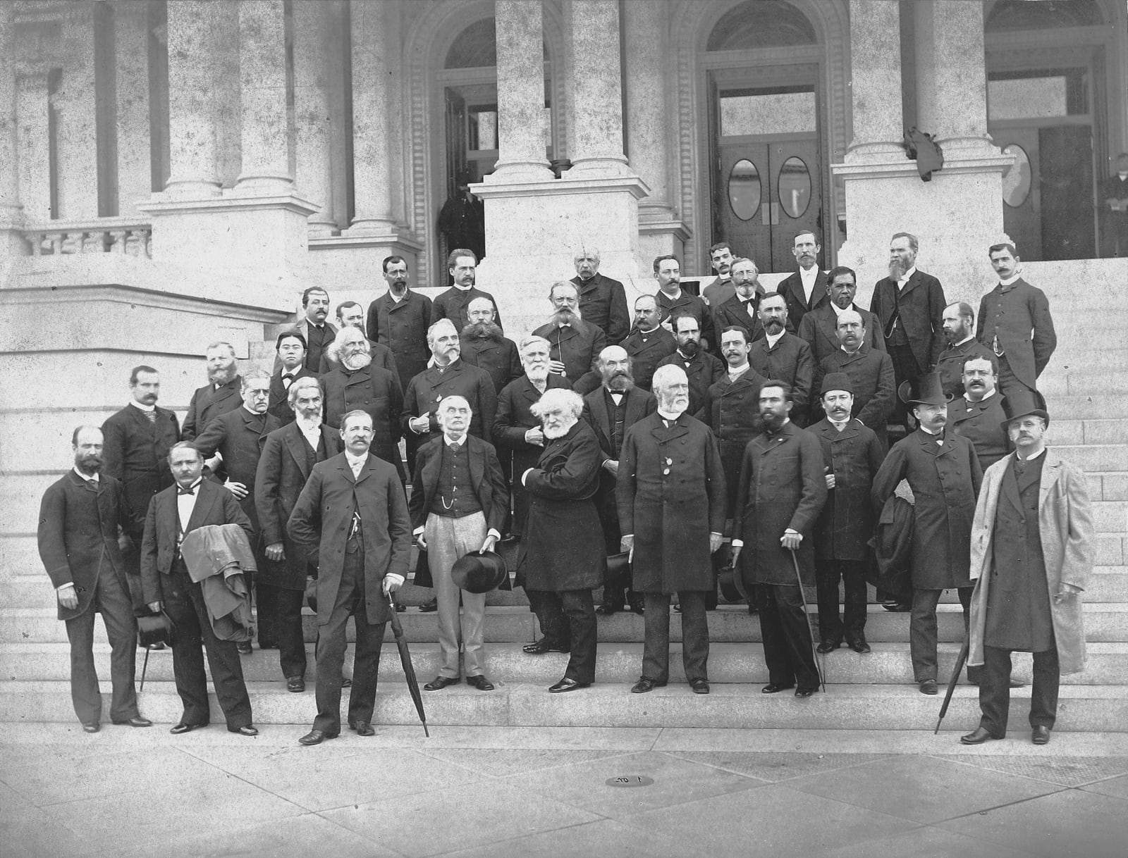
The archival photograph of the delegates is useful because it strips away the illusion that the prime meridian was merely a line painted across a courtyard.[4] It was also a room of officials and specialists trying to make a standard credible enough to cross borders. Some wanted neutrality; others argued for existing use. Some worried about national dignity; others pressed navigational convenience. The final text did not dissolve those differences. It made them administratively manageable.[1]
That is why the conference still rewards close reading. Its success lay in not overclaiming. It did not make Greenwich naturally central. It did not invent time zones. It did not erase French hesitation or every older meridian. It took a world with multiple reference lines and gave governments a common zero that could be adopted without remaking every clock at once.[1][2][3]
Zero longitude, then, was not a natural boundary waiting to be named. It was a diplomatic instrument: narrow, useful, voted on, and attached to a real telescope. That is why it lasted.
Sources
- Project Gutenberg, "International Conference Held at Washington for the Purpose of Fixing a Prime Meridian and a Universal Day. October, 1884" - primary protocols, debates, votes, and final resolutions.
- Royal Museums Greenwich, "What is the Prime Meridian - and why is it in Greenwich?" - Airy Transit Circle, Greenwich Observatory context, and practical reasons for choosing Greenwich.
- U.S. Naval Observatory, "U.S. Time Zones" - railroad standard time in 1883 and the U.S. Standard Time Act of 1918.
- Wikimedia Commons, "Delegates of the International Meridian Conference (cropped).jpg" - archival delegates photograph from October 1884, public-domain file metadata.