Dayton's 1913 flood is easy to file as a local catastrophe: hard rain, a swollen river, streets underwater, then a city rebuilding. That version is too small. The historical mechanism that matters is what happened after the water receded. The Miami Valley did not merely repair levees or wait for federal rescue. It built a new kind of regional institution that could tax, borrow, design, condemn land, and manage floodwater across city and county lines.
That is why the Miami Conservancy District still deserves attention as a history of governance, not only engineering. In March 1913, the Great Miami River and its tributaries turned Dayton and neighboring cities into one shared basin of danger. By 1922, the valley had converted that experience into five dry dams, miles of levees, channel improvements, a local funding model, and a legal structure strong enough to survive opposition.[2][3][4] The lesson was blunt: a river basin cannot be protected town by town if the water arrives watershed by watershed.
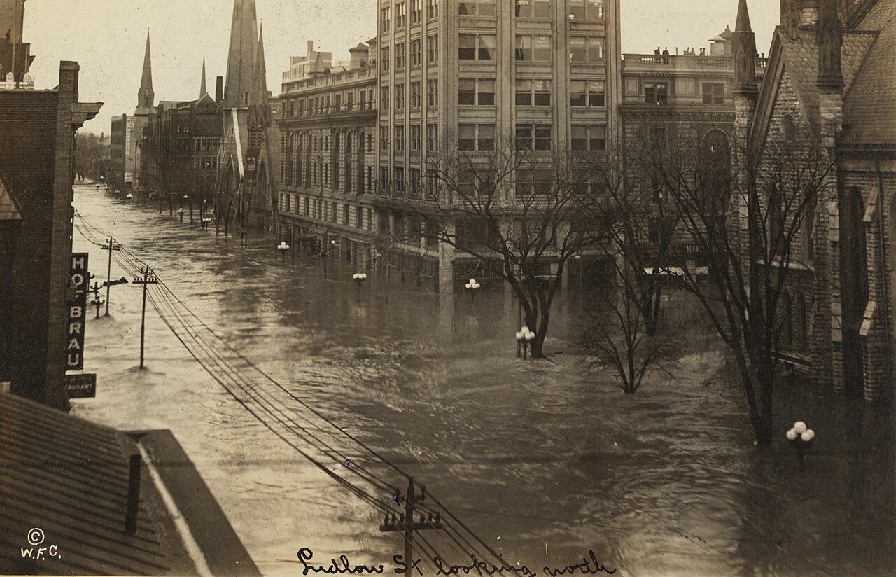
Image context: Ludlow Street under floodwater shows the problem from inside the city. The photograph is valuable because it makes the later engineering argument visible. Flood control had to be designed upstream, but its test was whether downtown streets, factories, homes, bridges, gas lines, and rescue routes could remain usable when the next basin-scale storm arrived.[1][6]
The Disaster Was Regional Before The Fix Was
The triggering conditions were not mysterious. The Miami Conservancy District's history page says that within three days in March 1913, nine to eleven inches of rain fell across the Great Miami River watershed, on ground already saturated by winter snow and ice melt.[1] The result was not one river leaving its channel in one place. It was a whole drainage network losing capacity at once. Every city along the river was overrun, and the district's account describes nearly four trillion gallons of water moving through the valley during the flood.[1]
That scale matters because it explains why ordinary municipal recovery would have been inadequate. A city can clean mud from streets, rebuild a bridge, repair a gas main, and reopen businesses. It cannot, by itself, control how much water arrives from upstream counties. The 1913 event made the gap between municipal boundaries and hydrological reality impossible to ignore.
Dayton was the most visible urban crisis, but the mechanism was valley-wide. Floodwater cut telegraph lines, stranded residents in upper floors and attics, carried away buildings and bridges, and fed fires through broken gas mains and spilled gasoline.[1] In the Miami Valley, more than 360 people died and property damage exceeded $100 million by contemporary estimates.[1] ASCE gives the broader flood-control project's origin in the same terms: the Miami, Stillwater, and Mad rivers flooded Dayton and surrounding communities, killing more than 400 people and causing more than $100 million in damage.[3]
The slight difference in death totals across summaries is useful rather than confusing. It shows that the disaster was being counted through different regional frames. What remained constant was the political conclusion: water did not respect the local lines by which people had been trying to manage it.
Relief Solved The Week; Prevention Needed A New Body
Emergency response came first. John H. Patterson of National Cash Register shut down business operations, turned company facilities toward shelter and medical aid, and organized employees as rescue and relief workers.[4] The American Red Cross arrived after the immediate local response began.[4] Those efforts saved lives and stabilized the city, but they could not answer the harder question: what institution could prevent the same kind of basin failure from returning?
The local answer began unusually fast. MCD records that some 23,000 citizens contributed more than $2 million to begin a comprehensive flood-protection program on a valley-wide basis.[1] The MRCC/Silver Jackets history gives the organizing sequence: on April 20, 1913, local committees combined into a Citizen's Relief Committee; May 25 and 26 became "Dayton Days" for raising the money needed to design a prevention system; and the committee hired Arthur Morgan's engineering firm to develop the plan.[4]
That sequence is the hinge. The valley did not treat flood prevention as a later public-works wish list. It treated it as the second phase of relief. Once the dead had been counted, the survivors had to decide whether rebuilding meant restoring the old exposure or building a different relationship between city and river.
Morgan's crucial move was to make the design larger than Dayton. MRCC's account says his plan was sized for a storm 40 percent greater than the 1913 flood and called for five dry dams, miles of levees, and river-channel improvements.[4] The design premise was not permanent storage or scenic reservoirs. It was controlled delay. Excess water would build behind dry dams during flood conditions, then release through outlets sized to avoid overwhelming downstream channels.[3]
That is the causal mechanism in engineering terms: do not try to make the river harmless everywhere at once. Hold part of the flood upstream, pass only what downstream channels can carry, and protect the urban corridor with levees and channel work matched to that controlled release.
The Missing Tool Was Legal, Not Technical
The valley could hire engineers before it could build the system. What it lacked was a legal form equal to the basin. MCD's Conservancy Act page states the problem plainly: Arthur Morgan realized that a regional flood-protection system would require work across city and county boundaries, but Ohio law did not yet allow that flexibility.[2] Dayton attorney John McMahon drafted the language, Representative Victor Vonderheide introduced the act, and Governor James Cox signed it into law in 1914.[2]
The Conservancy Act mattered because it gave water management a political subdivision that could match the physical problem. It authorized regional agencies to provide flood protection and gave conservancy districts a framework for governance and funding.[2] MRCC's account adds that the law was drafted after reviewing laws from other states and European flood-control examples, then signed on March 17, 1914.[4]
This is where the Dayton story becomes more than a disaster-recovery case. The decisive invention was not only a dam type. It was an institutional container for a river basin. Without that, five dry dams and a coordinated channel system would have remained drawings, because no ordinary city government could impose costs and land-use changes across the whole benefit area.
Opposition followed quickly. MCD says legal challenges delayed the district's formation for more than a year, and the Miami Conservancy District organized on June 28, 1915.[2] Cornell's text of Orr v. Allen preserves the later Supreme Court validation of the assessment model under which benefited lands could be charged for the conservancy works.[5] In practical terms, the decision helped settle whether the district could turn regional benefit into regional finance.
Dry Dams Made The Basin Legible
Construction began in 1918 and ran to 1922.[3][4] ASCE identifies the project as the first regionally coordinated flood-control system in the United States to use retention reservoirs for controlled release of floodwater.[3] Its components were concrete enough to test the institutional idea: five large dry dams, levee and channel improvements at nine communities, relocation of four railroad lines, removal of one village, and lowering of water and gas mains.[3]
Those details matter because they show the system's hidden complexity. A dry dam is not just an earthwork. It changes where temporary water can stand, what land must be kept open to flood, which railroads and utilities have to move, and which downstream channels can be trusted with a measured release. ASCE notes that the dams ranged from 1,210 to 6,400 feet long and 65 to 110 feet high, using 8.4 million cubic yards of fill.[3] The scale was physical, but the coordination problem was social.
The dry-dam logic also corrected a common flood-control temptation. After a disaster, a city often wants a visible wall against the last waterline. Dayton's answer was more subtle. The wall alone was not enough. The basin needed upstream retarding basins, outlets, levees, channel work, assessments, easements, and maintenance. Protection came from the fit between pieces, not from any single dramatic structure.
MRCC's summary gives the payoff in a striking form: the project cost just over $30 million, was completed in five years, and since implementation in 1922 the protected areas have recorded zero flood damages.[4] That claim should be read carefully. It does not mean floods vanished from weather. It means the designed system changed how flood energy reached the protected corridor.
Why Dayton's Afterlife Was National
The Dayton mechanism traveled because it joined three things that are often separated: hydrology, law, and finance. Hydrology defined the real operating unit as the watershed. Law created the conservancy district. Finance converted distributed benefit into bonds and assessments. Engineering then had a durable owner.
That combination helps explain why later observers treated the Miami Conservancy District as a model. ASCE says the completed system was heralded nationally, and that its technical reports informed later flood-control projects, including work associated with the Tennessee Valley Authority.[3] MRCC similarly frames the Ohio Conservancy Act as influential beyond the state, copied or echoed by other states and folded into a broader federal interest in flood-control studies and legislation after 1913.[4]
The broader policy afterlife should not be exaggerated into a simple line from Dayton to every later federal program. The United States still fought over who should pay for flood control, how much prevention should be federal, and whether floodplains should be defended, vacated, or regulated. But Dayton supplied a working demonstration of a principle that later flood policy kept rediscovering: prevention is cheaper and more durable when the institution is built at the scale of the water.
The 1913 flood therefore belongs beside the famous urban disasters that made private or local risk into public obligation. Its distinctive contribution was the basin-scale answer. Dayton did not only rebuild a city after March 1913. By 1914, it had helped change Ohio law; by 1915, it had organized a new district; by 1918, it was building; by 1922, it had a functioning regional system.[2][3][4]
That sequence is the real history. The flood made local suffering visible. The conservancy district made regional prevention administratively possible. The dry dams made floodwater wait. The assessments made the system financeable. The lasting achievement was not that Dayton conquered nature. It was that the Miami Valley stopped pretending a watershed could be governed as a patchwork of separate towns.
Sources
- Miami Conservancy District, "Great Flood of 1913" - regional rainfall, saturated-ground context, valley damage, deaths, fundraising, and Arthur Morgan's hiring.
- Miami Conservancy District, "The Conservancy Act" - Ohio law enabling regional flood-protection agencies, Morgan's boundary problem, McMahon's drafting, Vonderheide's sponsorship, and the June 28, 1915 organization of MCD.
- American Society of Civil Engineers, "Miami Conservancy District" - historic landmark page on the 1918-1922 flood-control project, dry dams, retarding basins, levee/channel works, and national engineering influence.
- Midwestern Regional Climate Center / Silver Jackets, "1913 vs. Today - After the Floods" - post-flood relief, local fundraising, Morgan's design target, the Conservancy Act sequence, construction cost, and federal-policy afterlife.
- Cornell Legal Information Institute, "Orr v. Allen, 248 U.S. 35 (1918)" - Supreme Court text concerning the Ohio conservancy assessment challenge.
- Wikimedia Commons, "Ludlow Street - North - Dayton Ohio great flood of 1913.jpg" - source page for the archival street photograph used as the article image.