At 9:00 p.m. on 8 September 1923, the lead ship of a U.S. Navy destroyer squadron turned east off the California coast. Captain Edward H. Watson and Lieutenant Commander Donald T. Hunter believed USS Delphy had reached the entrance to the Santa Barbara Channel. Fourteen destroyers were running in a single column through darkness and coastal haze, with fog obscuring the coast ahead. Thirteen ships began to copy the flagship’s turn.[1][2]
They were not at the channel entrance. They were still north of Point Arguello and close to the hard volcanic shore at Point Pedernales, commonly called Honda Point. At roughly 20 knots, the error needed only about five minutes to become irreversible. Delphy drove bow-first into rock. S. P. Lee sheered aside and struck the bluff. Young opened her starboard side on a submerged pinnacle and rolled over. Woodbury, Nicholas, Fuller, and Chauncey followed into the wreck field. Seven nearly new destroyers were lost; two more touched bottom or rock before backing clear. Twenty-three sailors died.[1][2][5]
Calling Honda Point a navigational error is correct but incomplete. It does not explain why one ship’s uncertain position became an order for an entire formation, why several available checks failed to interrupt it, or why the disaster stopped halfway down the column. Reconstructing the day shows a system that moved confidence forward and doubt sideways. The ships were separate hulls, each with a captain and a bridge, but for the decisive turn they navigated as though they were one vessel.
7–8 September: a speed test acquires a deadline
The chain began before the coast disappeared. On 7 September, Watson and his principal officers discussed the next day’s passage from San Francisco to San Diego. Postwar fuel economies had kept destroyers from making routine high-speed runs. The new trip offered permission to test their cruising turbines at 20 knots. Another squadron received the same opportunity but treated the speed as optional; Watson’s Squadron 11 treated it as the standard the passage should meet.[2]
That distinction matters. A 20-knot run was not inherently reckless, and speed alone did not aim the ships at Honda Point. But it changed the price of every precaution. Moving a division shoreward to identify a lighthouse could disrupt the formation. Taking depth soundings required slowing because the available sonic equipment would not work reliably at the test speed. Waiting for a better position postponed the eastward turn and spoiled the run. Each check appeared to demand a small retreat from the exercise’s purpose.[2][4]
Squadron 11 left San Francisco shortly before 7:00 a.m. on 8 September. After tactical and gunnery exercises, the destroyers headed south. USS Delphy carried Watson, the squadron commander; Hunter, the ship’s captain and acting navigator; and Lieutenant (junior grade) Lawrence Blodgett, the designated navigator, whose role Hunter had narrowed. The flagship’s gyrocompass was out, so its bridge used the magnetic compass. None of those conditions alone determined the outcome.[2]
At 11:30 a.m., the squadron passed Pigeon Point, the last landmark that supplied a firm visual position. From there, coastal haze hid Point Sur and then Piedras Blancas. The ships continued by dead reckoning: course, estimated speed, elapsed time, and allowances for wind and current carried the last known point forward on the chart. Dead reckoning is a disciplined estimate, not a sighting. Its errors accumulate quietly because the plotted track remains precise even when the ship has slipped away from it.[2]
2:15–8:58 p.m.: three ways to know, one skipped check
The squadron still had two ways to test its estimated position. One was depth. The other was radio direction finding, then a young navigational service. A shore station rotated a loop antenna to determine the line along which a ship’s signal arrived. Early equipment could leave a 180-degree ambiguity: the same line pointed in two opposite directions. Multiple bearings, motion between observations, and judgment were needed to turn that line into a useful position.[2][4]
At 2:15 p.m., Point Arguello’s station sent Delphy a bearing that appeared to put the ship implausibly south of the station. When Hunter asked for the reciprocal, the answer placed the squadron northwest of it, where the ships actually were. The exchange gave him a reason to distrust the service. It also showed why the new instrument could not simply replace seamanship: a correct observation still needed to be requested, interpreted, compared, and repeated.[2]
The organizational choice was as important as the apparatus. To keep a busy radio channel clear, the flagship handled the squadron’s direction-finding traffic. Other ships could calculate their own dead-reckoned positions, and some quietly monitored bearings. Standard practice called for the lead navigator to compare his work with the division commanders before reporting the squadron’s position, but that check was skipped. At 8:00 p.m., the flagship transmitted a position that placed the squadron south of where it really was. Officers elsewhere in the column held estimates that differed by miles. No correction climbed the chain.[1][2]
There were fresh electronic warnings. USS Stoddert, well back in the formation, requested bearings at 8:11 and 8:32 p.m. that put it northwest of Point Arguello. At 8:39, Hunter requested another bearing and received 330 degrees—again northwest. Shipboard logs record a 168-degree answer after he asked for the reverse direction, although the shore station’s log does not record sending it. Hunter accepted the southward implication because it fit his belief that the squadron had passed the point. A final reading at 8:58 again indicated the ships were north of Point Arguello. He rejected that implication because it conflicted with the track he trusted.[2]
This was not a simple contest between obsolete dead reckoning and a flawless new machine. The radio system required trained use and could present ambiguous lines; the Library of Congress history of the coastal network records that mariners initially distrusted the technology and that confidence grew only with experience.[4] The failure at Honda was a failure to reconcile unlike evidence. Visual fixes had vanished, the depth check was deferred, radio bearings were made to fit the existing estimate, and other ships’ doubts remained unofficial. Three imperfect methods could have constrained one another. Instead, one method became the judge of the other two.
9:00–9:05 p.m.: course 095
At 9:00 p.m., Delphy turned onto course 095—almost due east—where Watson and Hunter expected open water. The flagship did not first transmit the course change, so the ships behind recognized the maneuver and followed it in hurried succession. Fog swallowed the leader. The destroyers were spaced only a few hundred yards apart.[2]
At 20 knots, a ship moves a little more than ten metres each second. A 300-yard gap therefore represents less than half a minute of travel. That calculation is an inference from the reported speed and spacing, but it exposes the geometry of the accident: a warning had to be recognized, understood, signalled, and acted on faster than the next ship could arrive. Close formation converted a navigational error into a propagation problem.
Between about 9:04 and 9:05, Young struck a pinnacle and capsized rapidly while Delphy hit bow-first and S. P. Lee swung into the bluff. Delphy sent warnings to keep west and turn, sounded its siren, and displayed a short-range blinker message that it was aground. The messages could not recall the front of the column. Woodbury and Nicholas entered the rocks; then Farragut, leading the next division, saw ships slewing and stopping ahead and ordered emergency action. Fuller passed into the trap after colliding with Farragut. Chauncey, farther back, was caught by the sea and forced against the wreck area near Young.[1][2]
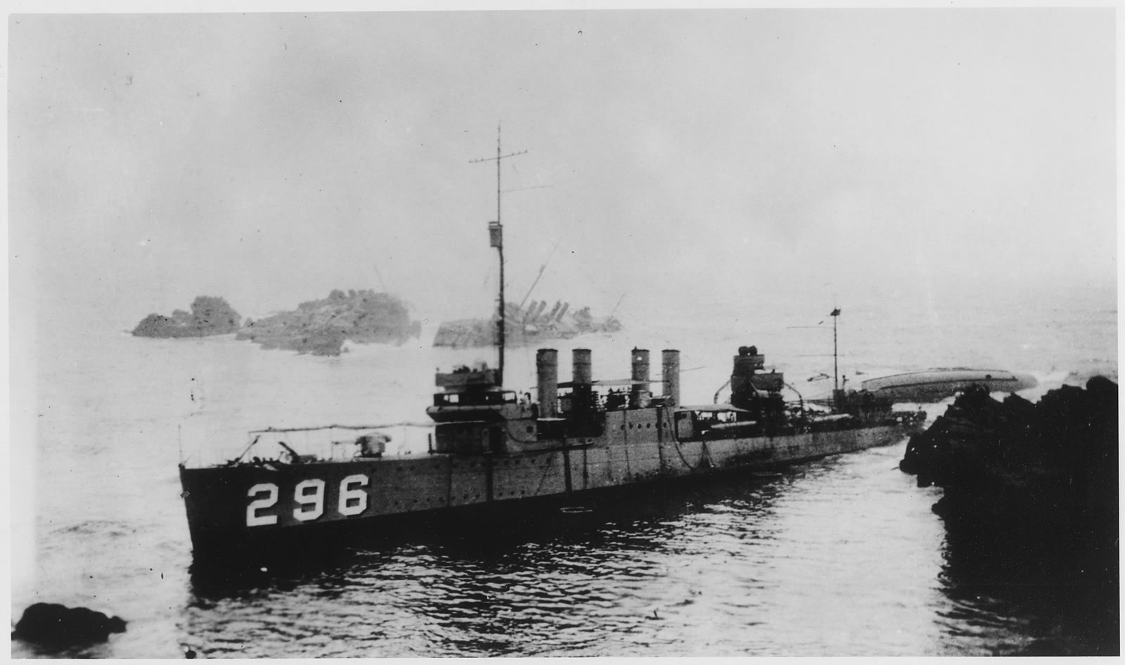
The photograph above is not a generic aftermath scene. Chauncey stands upright in the foreground while Young lies overturned and Woodbury appears beyond. It makes formation visible after formation has ceased to exist: three numbered hulls occupy different angles among the same rocks.[8]
The ships that stopped following
The wrecking ended because information finally outran the order. Sirens, lights, surf, and the silhouettes of ships at impossible angles made the flagship’s presumed location less credible than the water directly ahead. Farragut and Somers made contact but backed away. Percival and the four ships of the last division avoided total loss. The official Navy summary credits alarms with buying the rear of the column time; the deeper point is that survival required the captains behind to stop treating faithful station-keeping as the safest act.[1][3]
Some ships were better placed to do that. Commander Walter Roper, leading the last division in Kennedy, had listened to the conflicting bearings and opened distance before the turn. When Kennedy felt contact, her captain backed and sounded the depth: seven fathoms, perilously close to shore. Roper then held the other ships behind him rather than letting them pass into the confusion.[2]
The contrast with Squadron 12 sharpened the inquiry’s problem. It had travelled the same coast under the same permission for a fast run. Its commander took radio bearings seriously, slowed, and reached San Diego. Fog, sea state, and imperfect instruments formed the environment; they did not dictate one response.[2]
9:05–11:30 p.m.: a wreck becomes a bridge
On Young, the sequence changed from navigation to escape within minutes. Water entering the torn starboard side rolled the destroyer until survivors were clinging to the exposed port hull. Men in the fire and engine rooms were trapped below. Twenty of the disaster’s twenty-three dead came from Young.[1][2]
The grounding of Chauncey—itself part of the catastrophe—shortened the open water between the survivors and another deck. Chief Boatswain’s Mate Arthur Peterson swam a line through the surf, and one of Chauncey’s life rafts then worked as a ferry. About two and a half hours after Young struck, all of its survivors had been brought across. Lines from the wrecks to rocks and cliffs, boats from ships that had escaped, railroad workers, local fishermen, and ranchers extended the rescue beyond the formal command structure. The last sailors were not brought off the wreck field until the afternoon of 9 September.[1][2][3][9]
There is a revealing inversion here. The same close grouping that multiplied the grounding also placed crews within reach of one another. Chauncey was lost, but its accidental position made it a platform for saving Young’s exposed survivors. Before 9:05, disciplined repetition carried danger down the line. After 9:05, sailors improvised across hulls, surf, rock, shore, and rail. Coordination remained essential; certainty about a single plan did not.
17 September onward: assigning responsibility
A Court of Inquiry opened on 17 September and spent nineteen days taking evidence. It recommended eleven officers for courts-martial, including Watson, Hunter, Blodgett, division leaders, and the captains of the wrecked ships. The later trials convicted Watson and Hunter; a conviction against Nicholas’s captain was set aside. The official 1923 Navy report put the loss at seven ships, twenty-three lives, and $13 million in property.[2][5]
Responsibility did not end with the men who plotted the flagship’s track. The inquiry treated each commanding officer as responsible for his own ship, even inside a formation. A later congressional claims report described the S. P. Lee loss as due to negligent navigation by its commanding officer and added that the squadron commander was also at fault; it did so while compensating an officer whose personal effects vanished in the wreck.[6] The legal record thus resisted the idea that “following orders” dissolved a captain’s independent duty to notice danger.
The surviving paper trail also sets a boundary around this reconstruction. The Library of Congress finding aid for the Curtis L. Malaney Papers identifies two folders of court-martial proceedings and ten folders of Court of Inquiry material.[7] This essay draws on published official summaries and documented synthesis, not a complete reading of those files. Where the published account reports disputes over currents, radio practice, individual conversations, and blame, it leaves them as disputes rather than reducing the night to one villain or one defective device.[2][7]
The strongest conclusion is narrower. Honda Point became a seven-ship disaster because the squadron coupled centralized navigation to fast, close formation while bypassing the standard comparison that might have elevated contradictory evidence. The speed trial made verification feel costly. The flagship’s hierarchy made its estimate authoritative. The column’s geometry made correction late. Fog hid the consequence until ships could see wrecks rather than uncertainty.
One premature turn caused the first contact. The organization of the passage determined how many ships inherited it.
Sources
- Naval Historical Center, “Honda Point Disaster, 8 September 1923,” archived Online Library of Selected Images — official overview of the formation, groundings, ship losses, rescue, and casualty total.
- Noah Andre Trudeau, “A Naval Tragedy’s Chain of Errors,” Naval History 24, no. 1 (February 2010) — detailed reconstruction of the speed run, navigation, radio bearings, turn, rescue, and proceedings.
- Andy Ludlum, “Disaster in the Devil’s Jaw,” Museum of Ventura County (28 August 2023) — local archival account of rescue, shore communications, salvage, spectators, and the wrecks’ destruction by surf.
- Historic American Buildings Survey, Point Reyes Radio Compass Station, Barracks, HABS CA-2898, Library of Congress — institutional history of early coastal radio-direction finding and mariners’ changing trust after Honda Point.
- United States Navy Department, Annual Reports of the Navy Department for the Fiscal Year 1923 (Including Operations to November 15, 1923) (Washington: Government Printing Office, 1924), p. 79 — contemporary official account of the Honda Point losses.
- U.S. House of Representatives, Claims Adjusted in the Navy Department, 69th Congress, 1st session, House Document 154 (4 January 1926) — official claims record describing responsibility for losses of personal property aboard the wrecked destroyers.
- Library of Congress, Curtis L. Malaney Papers: A Finding Aid to the Collection in the Library of Congress — location and scope of surviving Honda Point Court of Inquiry and court-martial records.
- U.S. National Archives and Records Administration, “Point Honda wrecks, vessels 296, 309, and 312,” NAID 295531 — official catalog record for the U.S. Navy photograph; Wikimedia Commons preserves the downloadable high-resolution derivative and its provenance. High-resolution image record.
- Naval Historical Center, “Honda Point Disaster: Surface Views of the Southern Wrecks,” archived Online Library of Selected Images — official account of Young’s capsize, Peterson’s line swim, and the raft transfer to Chauncey.