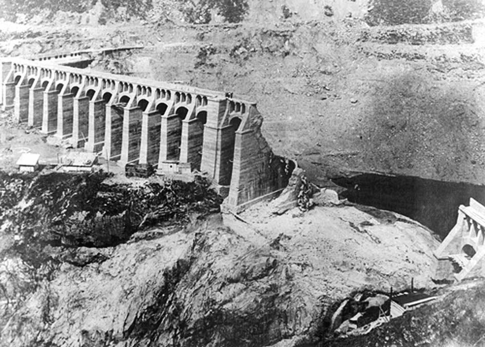
On the morning of 1 December 1923, the Gleno dam in the Italian Alps lost its central section. About 4.5 million cubic metres of water escaped through a breach roughly 80 metres wide. The reservoir emptied in minutes; the disaster continued down the valley.[1]
In the archival photograph, a row of surviving buttresses ends abruptly beside the breach. The masonry below remains visible.[1] The image poses the question the morning left behind: how did a structure lose its middle while substantial parts of it stayed standing?
To follow the morning, it helps to keep three processes separate. The structure failed. The released water travelled. People then had to discover the extent of the destruction while moving through the landscape it had damaged. Each process left a different kind of evidence.
A change of design above an existing base
The original scheme called for a gravity dam, a substantial mass resisting water pressure through its weight. Robert B. Jansen’s Dams and Public Safety, published by the U.S. Bureau of Reclamation, describes the contractor’s substitution of a multiple-arch design while official review was still under way.[2]
The result combined two structural arrangements. A masonry base closed the deepest part of the gorge. Above it stood the central portion of a lighter reinforced-concrete dam, whose arches passed their loads into buttresses. The wings rested directly on rock. A recurring shape across the skyline therefore concealed a change in support beneath it.[2]
Jansen’s account identifies poor materials and workmanship, including lime mortar where cement mortar had been specified and porous concrete. These details matter because the dam’s strength depended on more than the outline of its drawings. Forces had to pass through actual joints and actual masonry. A neatly repeated arch could not compensate for an unreliable support below.[2]
The crucial question was whether the completed combination would behave as its designers expected when the reservoir filled. Completion of construction and proof of performance were separate events, even though the finished structure could make them look like the same achievement.
A crack becomes an opening
The caretaker supplied a rare eyewitness account of the failure itself. In their 2011 hydraulic reconstruction, Marco Pilotti and colleagues use his trial testimony to place the initial collapse at 7:05 a.m. They describe a buttress and its adjoining arches falling first, followed by two further stages that enlarged the breach. The caretaker estimated that emptying took 12–15 minutes.[1]
That sequence changes the familiar image of a dam bursting. An opening developed through successive losses of support. The water did not need the entire barrier to disappear before it could escape, and the surviving wings could remain standing while the reservoir drained through the missing middle.
Pilotti’s team had to estimate some intervals between those stages.[1] That limitation matters: the sequence rests on testimony, while a second-by-second replay would require evidence the researchers did not possess.
The flood acquires a valley
The U.S. Bureau of Reclamation’s 2014 draft case-history compilation, drawing on the hydraulic study and other accounts, puts the flood’s journey to Darfo at about 45 minutes. It records destruction along the Dezzo and further, less severe damage along the Oglio toward Lake Iseo. Its estimate of at least 356 deaths is a lower-bound figure, not a claim that every victim was individually accounted for.[3]
Distance alone gives a poor sense of the danger. The compilation describes a steep, confined route and classifies the flooding as highly destructive. Its calculated depths and velocities are model results, not readings from instruments operating beside the torrent. Photographs of stripped ground and ruined settlements provide a different check on what the water did.[3]
The distinction between arrival and maximum flow also matters. A model can assign a time to the largest discharge at a location; that is not necessarily the first moment water reaches it. Nor does travel time automatically become usable warning time. Someone must recognize the threat, communicate it, and reach people who can act. The compilation records no warning for this event.[3]
Once the dam had opened, the disaster’s geography extended far beyond the structure. Places separated by kilometres of mountain valley were connected by the moving reservoir.
Following the damage upstream
The front page of L’Eco di Bergamo on 3 December 1923 preserves the difficulty of learning what had happened. Its account says the first confused reports suggested a disaster near Lovere. Newspaper staff went there, learned that the Gleno dam was implicated, and continued toward the affected settlements.[4]
Their route matters. They encountered the catastrophe downstream before reaching its source. The report describes debris arriving through the Oglio, devastated houses and workplaces around Corna, and damage to the Via Mala road that obstructed access from Val Camonica into Val di Scalve. The writers faced a detour through the Presolana area to approach from another direction.[4]
This is evidence of disrupted communication as well as destruction. A broken road delayed the movement of witnesses, rescuers, and information. The newspaper’s uncertain questions about the missing belong to that immediate aftermath; they should not be silently converted into a final casualty register. Its value lies partly in showing how incomplete the picture remained while people were already trying to respond.[4]
Explaining the break after the water had gone
Later engineers could examine materials and surviving concrete, but the movement that initiated the collapse was harder to recover. Reclamation’s 2019 chapter on concrete buttress dams summarizes the official explanation: settlement of the masonry base produced abnormal stresses, with leakage and loss of lime mortar offered as part of that mechanism. It also notes an evidential limit: the base appeared largely intact afterward, and no before-and-after surveys established how far it had settled.[5]
That reservation does not make the dam sound. It separates a documented structural disaster from a fully measured account of its first movement. The strongest support for the settlement explanation is the connection between a vulnerable base and the distress above it; its weakness is the missing measurement of that base’s displacement. Surviving photographs alone cannot supply the absent survey.[5]
Responsibility followed a longer timetable. Enrica Belluco and Luigi Da Deppo’s centenary account records convictions of owner V. Viganò and designer and construction manager G. B. Santangelo in 1927, then Santangelo’s acquittal on appeal for lack of evidence in 1928.[6] A historical account that stops at the first verdict would misstate the outcome. Equally, the appeal does not erase the physical evidence that requires explanation.
Gleno’s history is clearest when those distinctions remain visible. The caretaker’s testimony follows a structure coming apart; the flood reconstruction follows water through terrain; the newspaper follows people struggling to reach the damage. Together they recover a morning in which the reservoir was already empty while communities downstream were still confronting what it had released.
Sources
- Marco Pilotti, Andrea Maranzoni, Massimo Tomirotti, and Giulia Valerio, “1923 Gleno Dam Break: Case Study and Numerical Modeling,” Journal of Hydraulic Engineering 137(4), 2011, pp. 480–492 — chronology, caretaker’s testimony, breach sequence, and modeling assumptions; University of Brescia PDF.
- Robert B. Jansen, Dams and Public Safety, U.S. Bureau of Reclamation, 1983, pp. 148–149 — design changes, supporting masonry, and construction defects (PDF).
- U.S. Bureau of Reclamation, RCEM: Dam Failure and Flood Event Case History Compilation, February 2014 interim draft, pp. 20–21 — Gleno flood travel, consequences, warning classification, and distinction between calculated hydraulics and historical evidence (PDF).
- L’Eco di Bergamo, front page, 3 December 1923 — contemporary reporting from the affected valley; newspaper scan preserved by the University of Bergamo (Italian, PDF).
- U.S. Bureau of Reclamation, “Risk Analysis for Concrete Buttress Dams,” July 2019, section E-5.10.1, pp. E-5-18–19 — official settlement explanation and limits of the surviving measurements (PDF).
- Enrica Belluco and Luigi Da Deppo, “1923–2023: The Centenary of the Gleno Dam’s Failure,” ICIRBM 2023 — conference-paper abstract in the University of Padua repository, including trial and appeal outcomes.