The 1900 Galveston hurricane is often retold as a story about a city that did not know what was coming. That is too clean. The sharper history is that Galveston received pieces of warning, but those pieces had to pass through an early Weather Bureau, incomplete Gulf observations, public judgment, low barrier-island geography, and fragile routes to the mainland. By the time the storm made the danger undeniable on September 8, 1900, warning had become an infrastructure problem.[1][2]
That is the causal chain worth tracing. The catastrophe did not come from weather alone, and it did not come from one person's misjudgment alone. It came from a system in which detection, communication, movement, and survivable ground all had to work together. They did not. Afterward, Galveston rebuilt as if the lesson were physical: a seawall, raised grade, dredged sand, lifted buildings, drainage, and a new civic memory of exposure.[3][4]
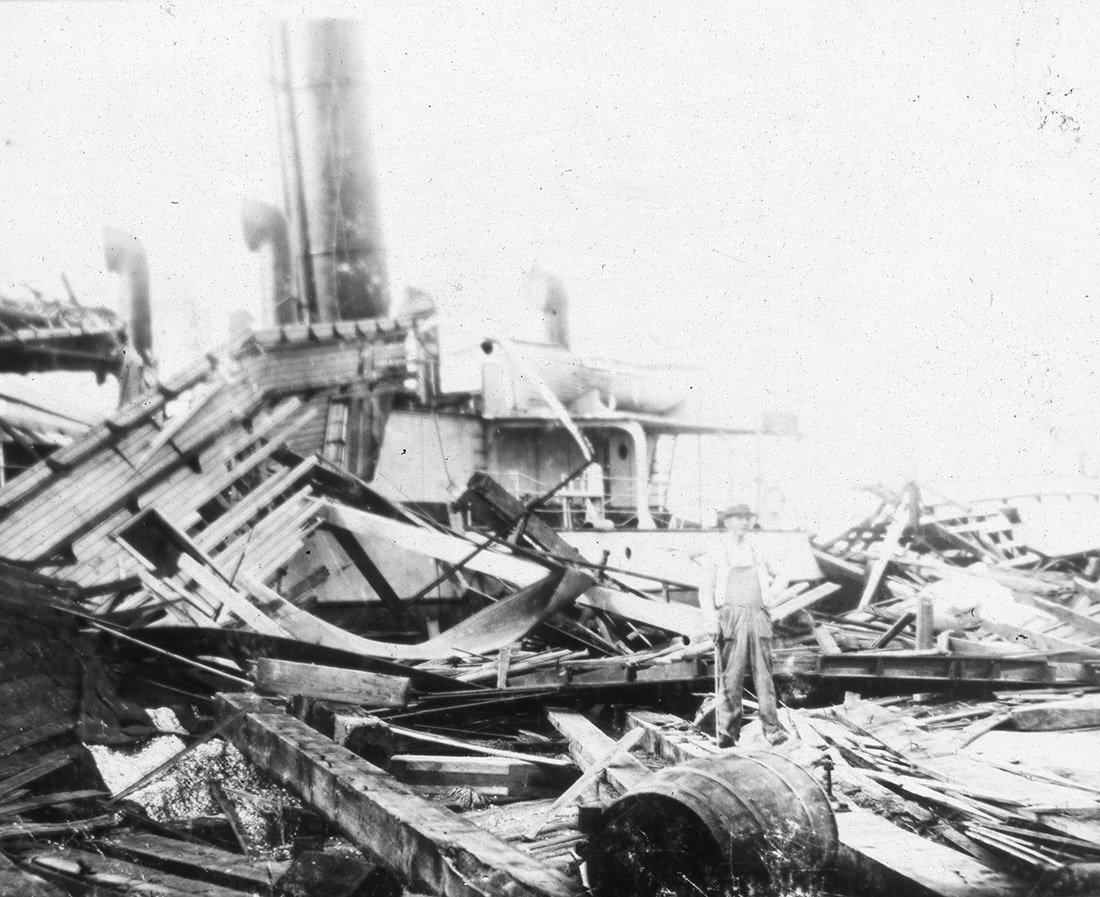
Image context: the cover is a real National Archives archival photograph of Galveston hurricane damage, published with a Prologue article on international relief records. It is used here because the article's argument is about physical vulnerability, civic recovery, and aid, not abstract hurricane diagrams or generated disaster imagery.[3]
The Warning Chain Was Narrow
On September 6, the U.S. Weather Bureau confirmed that a hurricane was in the Gulf and posted a hurricane watch as far west as New Orleans. On September 7, that watch was extended to the Texas coast. The National Weather Service's Houston/Galveston chronology makes clear that this was not a total absence of warning. There was official attention, and the storm was known to be in the Gulf.[1]
The limitation was scale and confidence. NOAA's later centennial account stresses that ship-to-shore wireless communication was not yet available in 1900, so information was sketchy and there was little knowledge that the hurricane was strengthening and heading toward Texas. Isaac Cline, Galveston's Weather Bureau manager, raised hurricane warning flags on September 7 and warned people along exposed areas, but those warnings still had to overcome a hard practical question: where could tens of thousands of island residents safely go, and how quickly?[2]
That is why the phrase "no warning" misses the mechanism. A warning is not just a sentence. It is a chain: observation, interpretation, official authorization, local credibility, transportation, shelter, and timing. Galveston had fragments of the early links. The last links were weak. By 4 a.m. on September 8, a driving rain had arrived; by 9 a.m., water around the island was already rising.[1]
The Island Made Delay Fatal
Galveston's exposure was simple and brutal. NOAA notes that the highest point in the city in 1900 was only 8.7 feet above sea level. The hurricane brought a storm surge of about 15 feet. The National Archives summary puts the city on an island only eight feet above sea level and says the storm virtually leveled it.[2][3]
Those numbers explain why the danger changed category. A high wind event can be survived by staying inside a strong enough structure. A storm surge higher than the city turns streets into channels and houses into debris. The Weather Service chronology records water more than five feet deep in streets by the evening, an anemometer lost after reaching 84 mph, sustained winds estimated at 125 mph, and the island awash with roughly 15 feet of water.[1]
The causal point is not that Galvestonians were uniquely careless. The point is that the city had little margin for error. If the forecast was late, if the warning sounded uncertain, if residents waited for visible proof, the geography removed the remaining choices. On a low island, a late warning is not merely less useful. It becomes almost impossible to act on.
The Exit Failed With The City
The most frightening part of the sequence is that escape routes did not simply become crowded; they disappeared. The Weather Service chronology says a steamship broke loose and crashed through all three bridges to the mainland, trapping the entire population on the island. Telegraph and bridge links were also cut, isolating the city as the storm turned local damage into a civic emergency.[1][3]
This is the part of the story that makes "better forecasting" necessary but incomplete. Even if more residents had believed the danger earlier, evacuation required time, transport, bridges, and somewhere to receive people. Once the mainland connection failed, Galveston was no longer deciding whether to leave. It was deciding how to survive in place while the island itself was underwater.
The death toll remains an estimate because the storm damaged the same social systems needed to count the dead. NOAA's centennial account gives more than 8,000 deaths and at least 3,500 homes and buildings destroyed; the National Archives notes estimates as high as 8,000 or more, and in a later postscript gives a range of 8,000 to 12,000 dead. The exact number matters less than the order of magnitude: this was the deadliest natural disaster in U.S. history.[2][3]
Relief Turned Ruin Into Records
After the wind dropped, Galveston became a relief problem before it became an engineering project. The National Archives article follows a revealing paper trail: relief funds formed across the United States and even overseas, with German consular networks sending money to help survivors. In that record, the disaster is not only wreckage. It is correspondence, lists, donations, accounting, and attempts to turn sympathy into usable aid.[3]
That archival trail matters because it shows the second half of disaster history. A storm destroys buildings quickly; recovery creates records slowly. Outside money could help survivors, but it could not restore Galveston's pre-storm assumptions. The city had been an important port and financial center. After 1900, its future had to be argued through protection, drainage, elevation, and confidence.[3][4]
The photograph used for this article sits inside that same recovery record. It shows damage, but the National Archives presents it in a story about relief, not spectacle. That is the right frame. The storm's historical meaning was not only the night of September 8. It was the paperwork, engineering, public finance, and civic decisions that followed.
The Seawall Was A New Warning System
Galveston's post-storm answer was not just to tell people to listen harder next time. It was to change the island. ASCE's landmark history says a three-member board of engineers, Henry Martyn Robert, Alfred Noble, and Henry Clay Ripley, was formed to recommend how to protect the city from overflows, raise it above overflows, and build a seawall. On January 25, 1902, the board recommended a curved concrete seawall rising 17 feet above mean low tide and stretching more than three miles along the oceanfront.[4]
Construction ran from 1902 to 1904 on an initial 17,593-foot seawall. ASCE describes a gravity section 16 feet wide at the base and 5 feet wide on top, with an embankment behind it. That design treated surge as a physical force to be met before it reached the street grid.[4]
Then came the grade raising. From 1903 to 1911, Galveston lifted sections of the city, raised utilities and streetcar tracks, and put buildings on hand-turned jackscrews. ASCE says around 2,000 buildings were raised, sand was dredged through a canal and pumped into residential districts, and roughly 500 city blocks were raised with 16.3 million cubic yards of sand.[4]
This was warning translated into concrete and elevation. The city did not abandon forecasting. It changed what a forecast could do. A future warning would arrive in a city with a seawall, higher ground, better drainage, and a civic memory that the Gulf could occupy the streets. In that sense, the seawall was not separate from the warning system. It was the warning system made durable.
The Lesson Is A Chain, Not A Slogan
The Galveston story is not a simple moral about technology before satellites. Modern forecasting is vastly better, but the 1900 mechanism is still recognizable. Risk becomes deadly when information, trust, routes, shelters, and physical protection fail to line up. A forecast can be right and still be too late for people without transportation. A warning can be clear and still be ineffective where there is no safe elevation. A city can remember a disaster and still have to decide how much protection it is willing to build.[1][2][4]
Galveston's answer after 1900 was extreme because the failure had been extreme. The storm exposed every weak link at once: uncertain data, late public urgency, a low island, broken bridges, destroyed communications, and a built environment that could not keep water outside. The rebuilding response joined those links back together as infrastructure. It made the city's future depend not on one heroic forecaster or one perfect message, but on a system that gave future warnings something to work with.[3][4]
That is why the disaster still deserves close historical reading. The deadliest natural disaster in U.S. history was not only a hurricane. It was a test of whether a prosperous coastal city had converted danger into institutions, routes, elevations, and habits before the water arrived. In 1900, Galveston had not. Afterward, it tried to make the lesson visible in the shape of the island itself.
Sources
- National Weather Service Houston/Galveston, "Upper Texas Coast Tropical Cyclones in the 1900s" - local chronology for the 1900 hurricane and later seawall test context.
- NOAA / National Weather Service, "National Weather Service Commemorates 1900 Galveston Hurricane" (September 7, 2000) - warning flags, storm surge, death toll, and seawall context.
- National Archives, Robert C. Greiner, "12,000 Marks for Texas," Prologue (Spring 2017) - archival damage photograph, relief records, death estimates, and aftermath summary.
- American Society of Civil Engineers, "Galveston Seawall and Grade Raising" - engineering history of the seawall, grade raising, dredged fill, and raised buildings.