The Dust Bowl tends to be explained as a natural disaster that also had human dimensions, or as a human disaster that drought made worse. Both framings are partly right but get the sequence wrong. The catastrophe of the 1930s required drought as its immediate trigger, but drought had visited the southern Great Plains before — in the 1890s and again in the 1910s — without producing anything comparable. What changed was the land itself. By 1929, roughly 100 million acres of native short-grass prairie had been broken by the plow, the native root network that bound soil to moisture was gone, and the region had been converted into a monoculture wheat belt that left bare soil exposed between harvests. The drought of the 1930s struck a fundamentally different surface than earlier dry cycles had found.[1][2]
This is the mechanism: structural precondition first, trigger second, cascading consequence third. Understanding the sequence is what separates the Dust Bowl from bad weather.
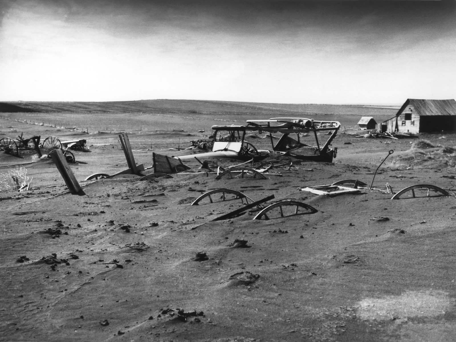
Image context: the cover photograph is a USDA image taken on May 13, 1936, showing a dust storm approaching Dallas, South Dakota. It is held in the public domain as a U.S. government photograph. The image suits this article because it records the mechanism in visible form: a wall of displaced topsoil moving across land stripped of its native root cover.[3]
1) The structural precondition: prairie sod went under the plow before the drought began
The southern Great Plains — southwestern Kansas, the Oklahoma and Texas panhandles, northeastern New Mexico, southeastern Colorado — is short-grass country. Its native cover is not what most people picture when they imagine grass. It is a low, dense mat of species like buffalo grass and blue grama that evolved under periodic drought and constant wind. The roots of these grasses extend several feet into the soil, binding particles together, retaining moisture, and making the surface resistant to wind erosion. That root network was the plains' structural defense against its own climate.[1][2]
The Homestead Act of 1862 and its successors opened this land to agricultural settlement, but the transformation accelerated sharply in two bursts. The first came in the late nineteenth century, when cattle ranching and early dry-land farming began breaking the sod. The second was driven by World War I. As European agricultural production collapsed between 1914 and 1918, wheat prices roughly doubled, and farmers on the southern plains responded rationally to price signals: they plowed up millions more acres of native grass and planted wheat. Federal agricultural extension agencies and state governments encouraged this expansion explicitly. The plow followed the price.[1][4]
By the mid-1920s, mechanized tractors had accelerated the rate of sod conversion still further. One tractor could turn more native prairie in a day than a horse-drawn team could manage in a week. By the late 1920s, the area of cultivated land on the southern plains had grown by several times its pre-war extent. And because wheat farming left fields bare for months between planting and harvest — and sometimes bare for entire fallow years — the surface that greeted dry weather was not native grass. It was exposed topsoil with no living root system holding it down.[1][2]
This is the precondition. The drought that began in 1930 did not encounter a resilient native landscape. It encountered a landscape that had been redesigned, over fifty years of settlement policy and wartime price incentives, in a way that eliminated the one feature that made it resistant to wind.
2) The trigger sequence: drought onset, soil failure, and the Black Blizzards, 1930–1935
Drought returned to the southern plains in 1930. By 1931, rainfall had dropped sharply across much of the region. Unlike the droughts of the 1890s and 1910s, this one encountered bare plowed fields and reduced root density. Topsoil that would have stayed in place under native grass cover began to move.[1][5]
The visible consequence was the "black blizzard" — a rolling wall of wind-driven topsoil that could darken a sky at midday and reduce visibility to zero. These storms were not new to the plains; occasional dust events had always occurred. What was new was their scale, frequency, and the depth of soil they moved. By 1934, drought and dust storms had extended across the entire region. A major storm in May 1934 carried an estimated 300 million tons of topsoil eastward, reaching as far as Chicago and depositing dust on ships in the Atlantic.[1][2]
The worst single event was April 14, 1935 — "Black Sunday." An exceptionally intense dust storm rolled across the Oklahoma and Texas panhandles, the most severe in a series that had been building for several years. The day gave the region its name: a reporter covering the aftermath wrote that the dust-covered landscape resembled a "dust bowl," and the phrase stuck.[2] Black Sunday was not the cause of the crisis; it was a visible peak in a continuous process of soil loss that had been intensifying for half a decade.
The storms were not merely dramatic. They were ecologically destructive in a compounding way. Each storm removed the uppermost layer of topsoil — the most fertile, most biologically active layer — and moved it downwind. Fields that had already been stressed by drought were further degraded by the removal of the very material that supported crop growth. The land was becoming harder to farm precisely at the moment when farmers were most economically desperate.[1][2][5]
3) The displacement chain and the federal response
The human displacement that resulted from the Dust Bowl was one of the largest internal migrations in American history. Between 1930 and 1940, an estimated 2.5 million people left the Great Plains states. Many moved west to California, following agricultural labor markets and the promise of irrigated farming. John Steinbeck's The Grapes of Wrath (1939) gave this migration its literary form; the photographs commissioned by the Resettlement Administration and Farm Security Administration gave it its documentary record.[3]
The federal response arrived in stages, driven partly by the ecological evidence and partly by political pressure from states unable to handle the scale of displacement. The Soil Conservation Service was established in 1935, with Hugh Hammond Bennett as its first director. Bennett had been arguing since the 1920s that erosion was a national emergency requiring federal intervention. The Dust Bowl gave him the political opening to act.[4]
The SCS promoted a set of practices that the pre-Dust Bowl farming culture had largely ignored: contour plowing (following the land's natural contours rather than straight rows that channeled runoff), strip cropping (alternating crops with grass or bare fallow to break wind and retain moisture), and the restoration of grass cover on the most erosion-prone land. The Prairie States Forestry Project, popularly called the "shelterbelt" program, planted a north-south belt of trees through the Great Plains to reduce wind velocity across open fields. These were not quick fixes; rebuilding soil structure takes decades.[1][4]
The Agricultural Adjustment Administration, established earlier in 1933 as part of the New Deal, paid farmers to reduce planted acreage — originally to address overproduction and low prices, but the policy also took the most marginal land out of wheat cultivation and allowed some natural grass recovery. The Taylor Grazing Act of 1934 ended open-range grazing on public lands, closing one of the other drivers of native cover removal.[1][4]
4) Why drought alone was insufficient: the earlier dry cycles as the counter-case
The mechanism becomes clearest by comparing the 1930s to earlier droughts. The southern Great Plains experienced significant dry periods in the early 1890s — severe enough to drive many homesteaders off their claims — and again in the early 1910s. Neither of those droughts produced Dust Bowl conditions. The reason is that in 1890 and 1910, a much larger portion of the plains remained under native grass cover. Drought reduced yield and imposed hardship, but it did not strip topsoil across millions of acres or generate the dust storms that defined the 1930s experience.[1][2]
The counter-case makes the causal argument precise. Drought was necessary but not sufficient. Native sod removal was necessary but not sufficient — earlier plowed fields in the 1890s had not produced equivalent damage partly because the scale of conversion was smaller and partly because the drought of the 1890s did not reach the same severity or duration. The Dust Bowl required the specific intersection of large-scale sod conversion accumulated over decades and a sustained drought long enough and intense enough to dry the exposed soil below the threshold at which wind could move it in massive quantities.[1][2][5]
The lesson is not that the plains should never have been farmed. It is that the methods and scale of conversion, driven by land policy and price incentives that treated the native grass as an obstacle rather than a structural asset, removed the one thing that made the land resistant to its own climate. The drought revealed the damage that had already been done to the land's capacity to survive drought. [1][2][4]
Sources
- Donald Worster, Dust Bowl: The Southern Plains in the 1930s. Oxford University Press, 1979 — the foundational causal and ecological history of the Dust Bowl, covering sod destruction, drought cycle, and policy response.
- Timothy Egan, The Worst Hard Time: The Untold Story of Those Who Survived the Great American Dust Bowl. Houghton Mifflin, 2006 — narrative reconstruction of life in the Dust Bowl counties, with detailed accounts of Black Sunday and storm conditions.
- Library of Congress, "Farm Security Administration/Office of War Information Black-and-White Negatives" collection — archival photographs documenting conditions in the Dust Bowl and Great Plains, 1935–1944, including Arthur Rothstein's Cimarron County images.
- USDA Natural Resources Conservation Service, "History of NRCS" — institutional history of the Soil Conservation Service (1935) and its land-use reform programs descending from the Dust Bowl response.
- National Centers for Environmental Information (NOAA), "Climate at a Glance: National Mapping" — historical drought severity and precipitation data for the Great Plains, including 1930–1940 drought periods.