
The Normandy landings are often remembered from too high above the water.[1][4] In retrospective memory, D-Day arrives as a grand plan fulfilled: arrows crossing the Channel, a coalition finally opening the western front, a beachhead that leads forward to Paris and then to Germany. The archival newsreel embedded below pulls the event back down to a more exact scale. Before D-Day became a victory map, it became a fight with surf, steel, and distance. Men had to get out of landing craft, stay upright in rough water, find gaps between obstacles, and cross a beach already organized for them to die on.[1][2][3]
That is why the footage still matters.[1][2] It preserves a basic historical truth that later summary can flatten. Large operations are often remembered as headquarters achievements, but they only become real when bodies move through a narrow physical environment. On Omaha Beach, the first environment that mattered was not France in the abstract. It was the first hundred yards: water, wet sand, shingle, obstacles, mined approaches, and the rising ground behind them.[3][5]
The strongest reading of D-Day, then, is not only that it was the largest amphibious invasion in history.[4] It is that Allied power had to survive a vicious act of compression. Years of planning, rehearsals, industrial buildup, and coalition command all had to pass through one thin strip where engineering, topography, and German fire briefly reduced strategy to a movement problem. The film shows that reduction with unusual clarity.[1][2][5]
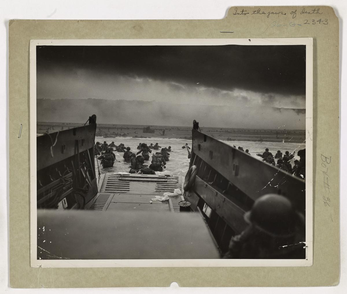
Image context: the cover uses the National Archives still photograph commonly known as Into the Jaws of Death, taken by Coast Guard chief photographer's mate Robert F. Sargent at Omaha Beach around 7:40 a.m. local time.[3] It is the right image for this article because it catches the invasion after the ramp drops and before the myth hardens. The men are already in the surf, already dispersed by danger, and still not ashore in any meaningful sense.
Historical context: Overlord only became history once the landing plan entered a hostile shoreline
The National Archives' D-Day records page is useful because it restores the invasion's scale without letting scale become abstraction.[4] Operation Overlord gathered a multinational force, an immense shipping effort, and years of preparation into one attempt to open Nazi-occupied France from the sea. The transcript for the newsreel emphasizes the same accumulation: Britain as an armed camp, loading rehearsals timed in advance, and a fleet of more than 4,000 ships putting out on June 5, 1944.[2] Those details matter because they remind the reader that the beach crossing was not improvised courage alone. It was the terminal end of a gigantic administrative machine.
Yet Omaha Beach shows why such a machine could still look terrifyingly fragile at the point of contact.[3][5] Robert Citino's National WWII Museum essay puts the terrain plainly: sea in front, bluffs behind, and between them German strongpoints positioned to dominate the exits from the beach.[5] The defenders did not need to hold every grain of sand equally. They needed to punish the approaches and the limited routes by which men and equipment could move inland. That is why the beach's physical features mattered so much. The usable exits were few, the defenders knew where they were, and the open approach left attackers visible for too long.[5]
Sargent's photograph, and the archival footage beside it, make this topography legible in a way that prose alone rarely can.[1][3] The key D-Day memory is often bravery, which is true but incomplete. The more exact historical mechanism is exposure. Men leaving landing craft had to cross water that slowed them, carry equipment that unbalanced them, and orient themselves in a field already clogged by obstacles and incoming fire.[3] The invasion's first success did not lie in planting a flag or seizing a symbolic point. It lay in surviving long enough to make the beach exits usable.
This is where the big and small scales meet.[2][4][5] The coalition could assemble fleets, aircraft, and assault doctrine; the shoreline could still force everything into a painfully local contest. D-Day at Omaha therefore belongs to two histories at once: one of enormous Allied coordination, and one of men trying to move from the ramp to the shingle under conditions that erased almost every illusion of smooth execution.
Video provenance
The embedded film is "D-Day 1944," published on YouTube by the US National Archives.[1] The National Archives identifies it as National Archives Identifier 39013, a motion-picture item from Record Group 208, the Office of War Information's United News newsreels.[4] The surviving transcript matters almost as much as the images because it reveals how the footage was framed for wartime audiences: vast preparation in England, massive naval assembly, then the crossing to a coast represented as the hinge of Europe's liberation.[2]
That provenance is part of the article's point. This is not a later documentary stitched together from testimony and hindsight. It is wartime archival film with a wartime voice. It condenses, dramatizes, and smooths; yet in doing so it still preserves the physical grammar of the landing that later commemorative language tends to soften.[1][2]
Close reading: the footage shrinks a continental operation into a shoreline problem
The first thing the film does is show how thoroughly D-Day depended on preparation before it ever reached France.[1][2] The narrator lingers over stockpiled vehicles, ships built for specific assault roles, and repeated loading drills. That emphasis has an obvious propagandistic function, but it also establishes a useful historical baseline. The invasion was designed to minimize improvisation. Every jeep, every tank, every soldier was supposed to fit a pattern.[2] That makes what follows more revealing, not less. Once the pattern reaches the beach, the environment starts tearing at it.
When the film turns to the landings, the mood changes from mass to bottleneck.[1][2] Barges approach shore, artillery opens, and the movement that looked so coherent in English ports becomes broken into small exposed increments. Landing craft can deliver men to the edge of France; they cannot make the water shallow, the footing stable, or the obstacles disappear. Sargent's still image sharpens the same fact. His photograph does not show a triumphal arrival. It shows soldiers already scattered by surf and enemy fire, some upright, some low, none yet in possession of the beach.[3]
That is the real value of the first hundred yards as a historical unit.[3][5] It is short enough to sound trivial on a map and long enough to kill a landing. In those yards, soldiers had to keep weapons and radios functional, avoid drowning or being pinned under weight, watch for mines and stakes, and reach ground where they could begin to return fire or move toward the exits.[3][5] The beach was therefore not a blank receiving surface. It was an engineered filter designed to slow, separate, and expose the assault force.
The footage also shows something that later commemorative language often understates: D-Day was visually confused even when the operation was strategically clear.[1][2] The narration speaks with certainty about a great decisive battle, but the images are full of partial views, interrupted sightlines, and moments in which motion is less like a smooth advance than a struggle not to stall out. That gap matters. It reminds the viewer that historical inevitability is usually imposed afterward. On the day itself, the invasion had to survive uncertainty at every local scale.
The film's limitations are therefore part of its usefulness.[1][2] As a wartime newsreel, it pushes toward coherence and uplift. It does not dwell on all the chaos, loss, or beach-specific differences that later historians would recover. Even so, it cannot prevent the harder physical facts from surfacing. Water resists. Obstacles interrupt. Men flatten themselves. Fire turns open ground into timed exposure. The camera keeps discovering that continental strategy has been reduced to a small, brutal crossing.
Why this archival moment still matters
D-Day still carries immense symbolic weight, and that symbolism is deserved.[4] But symbolism tends to clean the event up too quickly. It converts Omaha into courage in the abstract or into a necessary stage on the road to liberation. The archival film and Sargent's photograph resist that cleaning.[1][3] They return the invasion to a harsher truth: liberation had to begin as movement through a physically prepared kill zone.
That is why this footage remains so useful in 2026.[1][2][3][5] It does not just commemorate victory. It restores the cost of conversion from plan to fact. Overlord was a coalition masterpiece, but at Omaha it first had to become a successful passage through surf, obstacles, and the first hundred yards of exposed ground. The film survives because it lets us watch that passage before later memory turns it back into a line on a map.
Sources
- US National Archives, "D-Day 1944," YouTube video.
- National Archives and Records Administration, "Video Transcript for Archival Research Catalog (ARC) Identifier 39013: D-Day - 1944."
- National Archives, "Into the Jaws of Death, June 6, 1944" - Still Picture Branch highlight on Robert F. Sargent's Omaha Beach photograph used as this article's cover image.
- National Archives, "Records Relating to D-Day" - overview of archival records and identification of the "D-Day 1944" newsreel as National Archives Identifier 39013.
- Robert Citino, PhD, "On the Beach," The National WWII Museum - on Omaha's bluffs, resistance nests, exits, and why getting ashore was so difficult.