Chaco Canyon is easiest to underestimate when it is treated as a beautiful ruin in a remote place. The sandstone walls and open rooms can make the site feel static, as if its historical problem were simply how many people once lived there. The better question is more mechanical: how did a dry canyon in the San Juan Basin become a center for ceremony, trade, administration, construction, and movement between roughly AD 850 and 1250?[1][4]
The answer is not one miracle technology or one lost secret. Chaco worked by making distance part of the architecture. Great houses concentrated labor and ritual. Roads and outlying communities extended the system beyond the canyon. Timber from distant mountains made the buildings physically depend on regional reach. Astronomical and geometric positioning tied architecture to time, sky, and repeated ceremony. The result was not a normal village enlarged. It was a high-desert coordination system built from stone, wood, movement, and calendar logic.[1][2][3][4][5]
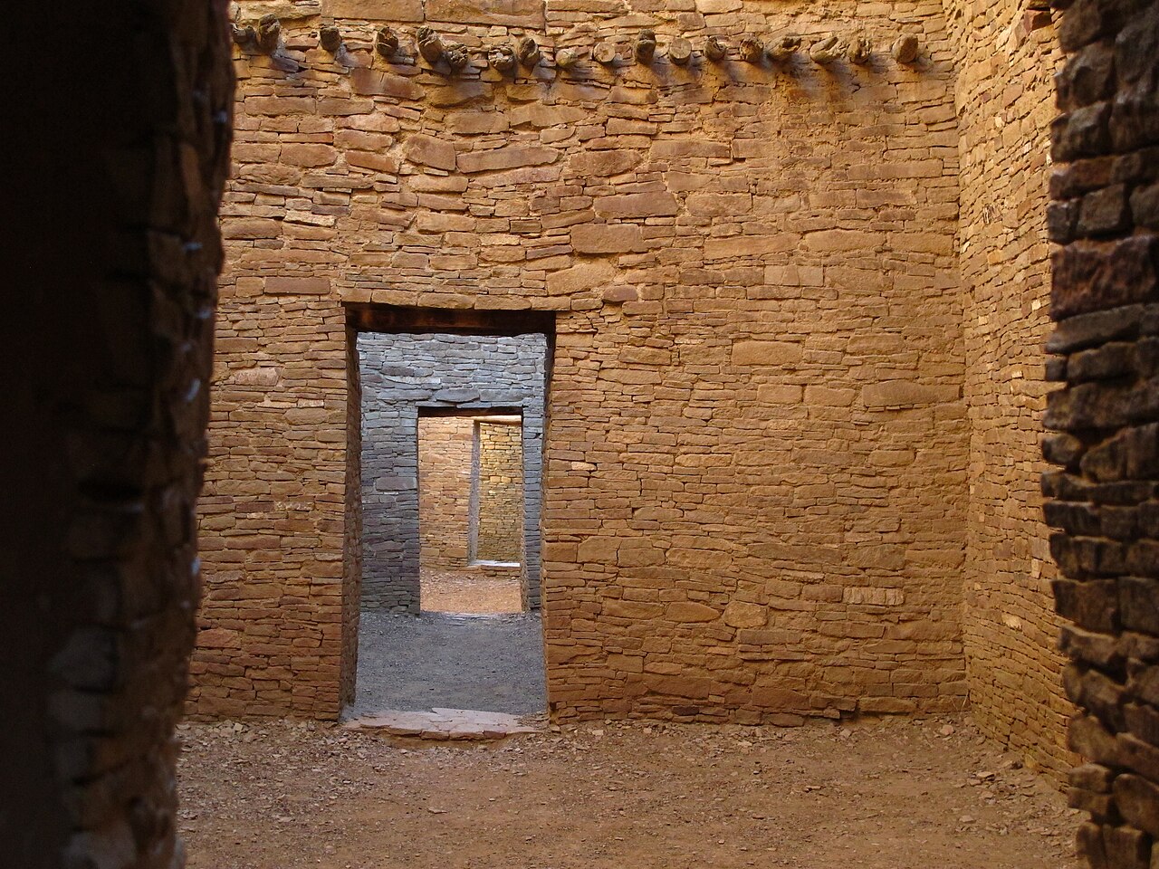
Image context: the cover photograph shows the interior of Pueblo Bonito, Chaco's most celebrated great house.[2][6] The visual evidence matters because Pueblo Bonito's walls are not just scenic remnants. They preserve the material problem the article is trying to explain: multistory masonry in a marginal landscape, built with beams and organization that had to come from well beyond the immediate canyon.
The first mechanism was architectural concentration
The National Park Service describes Chaco from AD 850 to 1250 as a hub of ceremony, trade, and administration for the prehistoric Four Corners region, marked by multistoried public buildings, ceremonial buildings, distinctive architecture, planned design, astronomical alignments, geometry, landscaping, and engineering.[1] Those words are important because they resist a simple settlement model. Chaco was not powerful because it merely gathered houses. It gathered public architecture.
Pueblo Bonito makes the mechanism visible at building scale. The NPS World Heritage account describes it as a D-shaped structure that took decades to build, ultimately reaching four to five stories and more than 600 rooms.[2] It also identifies Pueblo Bonito as a focus for ceremonial functions, administration, trading, storage, hospitality, communications, astronomy, and honored burials.[2] That is a crowded institutional vocabulary, but the crowding is the point. The building concentrated many kinds of activity in one form.
The Pueblo Period page gives the sharper architectural contrast. Great houses were distinct from ordinary domestic sites because their rooms could be three or four times larger, ceilings could be doubled in height, second through fourth stories were added, and specialized kivas became common features.[3] Thick rubble cores with finely coursed masonry veneer gave the buildings both strength and visual authority.[3] In other words, the great house was not simply a residence with more rooms. It was a different category of construction.
That distinction changes the interpretation. If Chaco is imagined mainly as population density, the ruins invite demographic arithmetic. If Chaco is read as architectural concentration, the ruins ask how labor, materials, ritual, and authority were organized to produce buildings whose scale exceeded ordinary household need. The visible mass of the walls is therefore evidence of coordination before it is evidence of occupancy.
The second mechanism was regional reach
Chaco's architecture did not stop at Chaco Canyon. The NPS World Heritage designation page explains that Chaco's inscription includes sites outside the park and that World Heritage recognition is a way to see the geographic reach of Chacoan society.[4] The UNESCO-linked statement of significance on that page points to monumental architecture, sophisticated astronomical understanding, and a complex road system as defining elements of a ceremonial, trade, and political center.[4]
The road system is the key to avoiding a narrow canyon-only reading. The World Heritage designation page notes that roads as wide as 30 feet led out of Chaco to the north and south and that other roads connected outlying great houses such as Kin Klizhin, Kin Bineola, Kin Ya'a, and Pueblo Pintado.[4] The NPS Pueblo Period page similarly describes road alignments with carved stairways and masonry ramps, water-control systems, earthen mounds, petroglyphs, pictographs, and calendrical markings as features of the prehistoric cultural landscape.[3]
These details show the second mechanism. Chaco's center mattered because it could organize peripheries. Roads did not have to function like modern freight highways to matter historically. They could mark direction, ritual movement, relationship, and repeated passage. Outlying great-house communities could give distant groups a Chacoan architectural grammar without requiring everyone to live inside the canyon. The region became readable through shared forms.
That is why the article's causal claim is bounded. The exact political nature of the Chacoan regional system remains debated. The NPS page says interpretations range from economic redistribution center to ritual or ceremonial center, socio-political center, or periodic pilgrimage site that facilitated exchange.[3] The uncertainty matters. We do not need to call Chaco a state, city, or empire in a modern sense to see the mechanism. The visible evidence points to regional integration even where the precise governing model remains unsettled.
The third mechanism was imported timber
The most concrete way to see Chaco's reach is to look up at the missing and surviving beams. Great houses in Chaco required huge quantities of construction wood in a landscape that was not itself a timber-rich mountain forest. A tree-ring sourcing study in PNAS frames the problem starkly: the great houses incorporated an estimated 240,000 construction timbers, and the source of that wood has long been a major archaeological question.[5]
Christopher Guiterman, Thomas Swetnam, and Jeffrey Dean tested 170 timbers from seven great houses and found that the Chuska and Zuni Mountains, both more than 75 km away, were the most likely sources for about 70% of the sampled beams.[5] Their timing evidence is just as important as the distance. Before 1020 CE, nearly all sampled timbers came from the Zuni Mountains; by 1060 CE, Chuska sources had eclipsed Zuni sources in total imports.[5] That shift coincided with the eleventh-century florescence of Chaco, when existing great houses expanded and seven new great houses were added in the core area.[5]
This makes timber more than a construction detail. Wood sourcing turns architecture into a map of obligation. Someone had to identify suitable trees, cut them, move them over long distances, and fit them into masonry buildings on a scale that could not be improvised one roof at a time. The beams therefore expose an operating system behind the walls. Chaco's buildings were local in stone but regional in wood.
The timber evidence also keeps the interpretation practical. It is tempting to describe Chaco's long-distance connections only through prestige goods or sacred geography. Those mattered, but beams are stubborn. They have weight, length, species, dates, and source signatures. They show that Chacoan regionality was not only symbolic. It entered the load-bearing structure of the buildings themselves.[5]
The fourth mechanism was time made architectural
Chaco's built environment also organized time. The NPS home page pairs preplanned architectural designs with astronomical alignments and geometry.[1] The Pueblo Period page names calendrical markings documenting solar, lunar, and stellar events among the landscape features of the canyon.[3] The World Heritage designation page likewise places astronomy, monumental architecture, and the road system inside a broader ceremonial, trade, and political center.[4]
The safest interpretation is not that every wall encodes a single solved astronomical message. The stronger claim is that orientation, geometry, and calendrical attention made built space participate in repeated time. In a ceremonial center, repetition matters. Seasonal returns, processions, gatherings, observations, and ritual cycles can make architecture socially active long after construction ends. The canyon's buildings did not merely occupy space. They helped schedule attention.
That scheduling function helps explain why Chaco cannot be reduced to resource extraction or impressive masonry alone. A road is not only a path if it points people toward a recurring gathering. A plaza is not only empty space if it frames repeated assembly. A kiva is not only an architectural feature if it anchors ceremonial practice. A beam is not only material if its transport demonstrates regional coordination. Chaco's power came from the way these parts reinforced one another.
Why the mechanism matters
By around AD 1150, the center of gravity shifted away from Chaco Canyon, and by AD 1300 the San Juan Basin was largely abandoned in favor of other Pueblo regions, according to the NPS synthesis.[3] That later movement should not be treated as simple collapse theater. It is better understood as a reminder that regional systems can be historically powerful without being permanent.
The more useful conclusion is specific. Chaco Canyon became a center because it made distance operational. Great houses concentrated authority and ceremony in monumental form. Roads and outlier communities extended the architectural language beyond the canyon. Timber procurement made distant mountains part of the construction chain. Calendrical and geometric attention linked buildings to recurring time. Together, those mechanisms made a marginal landscape behave like a regional institution.[1][2][3][4][5]
That is why Pueblo Bonito still feels larger than its walls. The ruin preserves not only rooms but relationships. Its masonry points to labor; its missing beams point to mountains; its road world points outward; its alignments point to recurring sky. Chaco worked because it made the outside world part of the building.
Sources
- National Park Service, "The Center of a Culture" - official Chaco Culture page on AD 850-1250, ceremony, trade, administration, planned architecture, astronomical alignments, geometry, and engineering.
- National Park Service, "Chaco Culture: World Heritage Site" - official overview of Pueblo Bonito, great houses, roads, five-story walls, regional influence, and Chaco's World Heritage context.
- National Park Service, "Pueblo Period" - archaeological synthesis of AD 700-1300 Chaco, great-house architecture, roads, water control, calendrical markings, regional-system interpretations, and post-1150 shifts.
- National Park Service, "Chaco World Heritage Designation" - official page on the 1987 UNESCO inscription, monumental architecture, astronomical understanding, complex road system, outlying sites, and Chaco's geographic reach.
- Christopher H. Guiterman, Thomas W. Swetnam, and Jeffrey S. Dean, "Eleventh-century shift in timber procurement areas for the great houses of Chaco Canyon," PNAS / PMC - tree-ring sourcing study of 170 timbers, distant Chuska/Zuni sources, and the eleventh-century procurement shift.
- Wikimedia Commons, "File:Pueblo Bonito - Chaco Canyon (IMG 0738).jpg" - source page for the real Pueblo Bonito photograph used as this article's cover image.