If you visit Cahokia now, memory arrives through one overwhelming shape: Monks Mound. It still rises roughly 30 meters above the plain, spreads across several terraces, and makes the site legible at a glance.[1][3] That surviving monument is real, and its scale still shocks. Yet the strongest historical question is not how large Cahokia once was. UNESCO describes it as the largest pre-Columbian settlement north of Mexico, with roughly 120 mounds across more than 1,600 hectares and a peak population of about 10,000 to 20,000 between 1050 and 1150.[1] The sharper question is how such a city came to be remembered so often as a vanished mystery rather than as Native urban history.
That change in memory did not happen in one step. It took at least three. First, later Americans reduced a city to a few dramatic earthworks and let Monks Mound stand in for the whole.[1][2][3] Second, as the University of Illinois's Mythic Mississippi project notes, settler culture promoted a "myth of the moundbuilders," insisting that the Native peoples visible to Anglo newcomers could not have built the monumental landscape before them.[4] Third, modern preservation and interpretation had to rebuild public understanding from a damaged remnant: UNESCO notes that the protected property preserves 51 mounds in its core area, while the state site says Illinois now protects about 2,200 acres and 72 of the nearly 80 remaining mounds in the larger central portion.[1][2] Cahokia therefore survives in public memory through a paradox. It is famous, but it is famous through reduction.
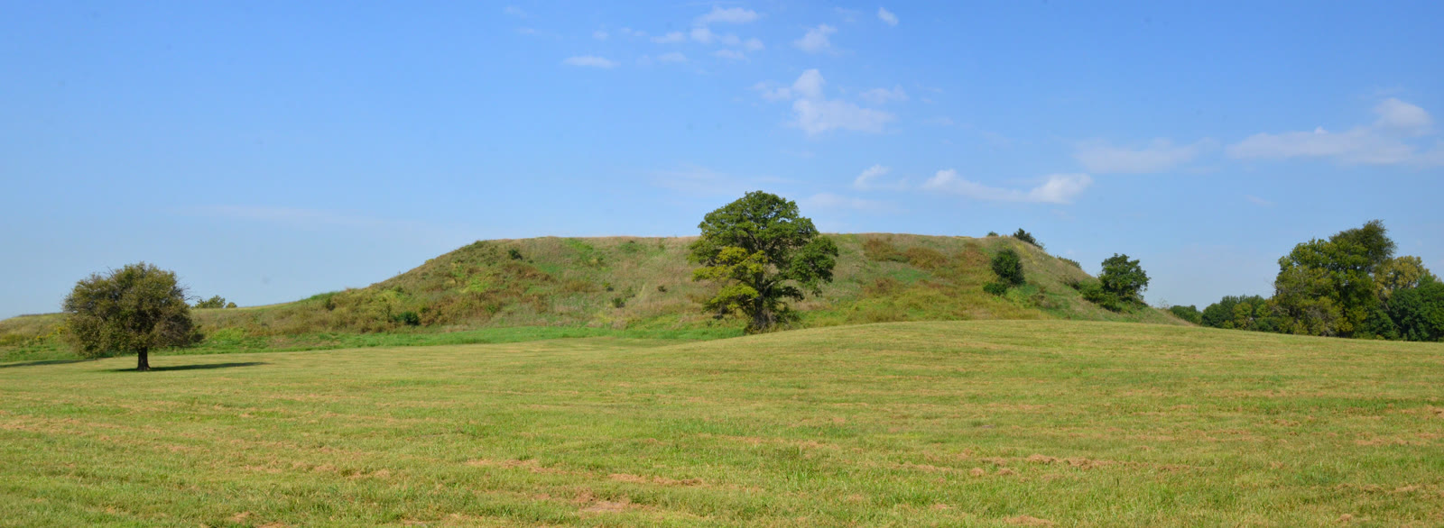
Image context: the cover uses a 2018 east-facing photograph of Monks Mound from Wikimedia Commons.[7] It is the right image for this essay because the article is about what later viewers can still see. Monks Mound keeps the city's mass in public view, but it also shows how easily one preserved shape can become a substitute for a much larger settlement whose other mounds, neighborhoods, and ceremonial spaces no longer dominate the eye.
Monks Mound became the city's public face
The scale of Monks Mound helps explain why memory settled there first. The official Cahokia Mounds page describes it as the largest man-made earthen mound in North America, about 291 meters north-south and roughly 100 feet high in its current form.[3] UNESCO's page adds that the mound was built in four terraces, in fourteen stages, and covers about six hectares.[1] A visitor does not need a reconstruction drawing to understand that labor on this scale required planning, hierarchy, and sustained civic purpose.
But that visual power has a cost. Monks Mound is so commanding that it can quietly flatten the city around it. UNESCO's larger description stresses that Cahokia was not one isolated platform. It included residential zones, public areas, specialized activity spaces, a reconstructed palisade, and the wider internal symmetry of a true settlement.[1] The state site's overview makes the same point more simply: at its height the metropolis stretched over 4,000 acres, encompassed about 120 earthen mounds, and held a population larger than London at the time.[2]
Once most of that wider landscape stopped being equally visible, the surviving giant had to do more commemorative work than any one structure should. It became the image on brochures, the proof of scale in quick summaries, and the object through which outsiders learned that a Native city had once stood near present-day St. Louis.[2][3] Monks Mound preserved memory, but it also narrowed memory.
Settler memory made the site harder to see
The distortion ran deeper than simple simplification. The University of Illinois page states the problem directly: when the Mississippian world collapsed and the earthworks remained on the landscape, early Anglo settlers promoted a "myth of the moundbuilders," claiming that the Native peoples they encountered were too "simple" to have built the monumental terrain.[4] That move was not an innocent mistake. It was a way of separating visible Native people from visible Native achievement.
This matters because the name Cahokia itself already records historical layering. Britannica notes that the site's modern name was borrowed from a later Illinois people in the region, not from the original builders' own surviving city name.[6] Public memory therefore began from an inherited mismatch: the builders' self-designation was lost, the monumental earthworks remained, and settler culture filled the gap with a story that placed true achievement in a remote or fictional past.[4][6]
In that framework, the mounds could be admired without granting continuity, intelligence, or city-making power to Native societies. The effect was double. Cahokia became easier to romanticize as a mystery, and harder to recognize as evidence that urbanism, political hierarchy, large-scale labor coordination, and ceremonial planning had deep Indigenous histories in North America.[1][4]
This is one reason the phrase "forgotten city" is both useful and misleading. It is useful because later Americans really did forget, downplay, or destroy much of what stood there. It is misleading because the forgetting was active. People were not simply confronted by an unintelligible ruin and left puzzled. They built interpretive habits that made Native achievement easier to misread.
Preservation changed the site from remnant to argument
Cahokia's twentieth-century afterlife was therefore not only archaeological. It was commemorative. UNESCO records that the core of the state historic site has been preserved as a protected public site since 1925, that the broader landmark designation followed in 1964, and that UNESCO inscription came in 1982.[1] The state site foregrounds the same modern ladder of recognition, noting National Historic Landmark status in 1965 and UNESCO designation in 1982.[2] The details differ because the site is being described at slightly different legal scales, but the larger point is clear: modern public institutions had to convert a damaged landscape into a defended one.[1][2]
That repair also had to be interpretive, not only legal. The University of Illinois page observes that most of Cahokia's mounds are gone, which means the museum and interpretive center carry unusual weight in helping visitors understand what no longer stands at full scale.[4] UNESCO likewise notes that a staffed interpretive center opened in 1989 and treats public interpretation as part of the preservation system.[1] In other words, Cahokia could not rely on intact stone walls or dense standing architecture to teach its own history. It needed curators, maps, reconstructions, signage, and argument.
That is a distinctive commemoration problem. Some sites remember themselves through abundance: enough material survives that visitors can infer the city's old grammar from the ruins alone. Cahokia's surviving earthworks still matter enormously, but the city now reaches the public through a mixed medium of preservation, archaeology, and explanation.[1][4] The commemorative act is not just to save the ground. It is to make a dispersed, partially erased urban order visible again.
New evidence has made the old disappearance story harder to keep
The other reason the "lost city" label now feels too neat is that recent scholarship has complicated the idea of a clean demographic void after Cahokia's peak. The American Antiquity article "After Cahokia" argues that the occupation history after AD 1400 has long been under-read and summarizes evidence for a more complex pattern: the region reached a population minimum by approximately AD 1400, had rebounded by AD 1500, reached a later maximum around AD 1650, and then declined again by AD 1700.[5]
That sequence matters for memory. It does not mean the great Mississippian city remained unchanged or that Monks Mound simply continued under the same political order. It does mean that "disappearance" is a dangerous historical shortcut. The article explicitly says that recognizing a post-Mississippian Indigenous population helps build a narrative of Native American persistence over Native American disappearance.[5] That is a major revision to the emotional grammar around Cahokia.
Once that evidence is taken seriously, the public story shifts. Cahokia no longer looks like a brilliant Native city that flickered out and left only mute mounds behind. It looks more like a place whose central urban phase ended, whose landscape remained, whose descendants and successor populations stayed historically relevant, and whose later interpreters repeatedly misframed what continuity could look like.[4][5][6]
What commemoration should do now
Cahokia is strongest in memory when it is treated as a site of correction as well as wonder. Wonder is easy: Monks Mound still delivers that immediately.[1][3][7] Correction is harder and more important. It requires saying that the surviving giant is only one part of a much larger city, that the old mound-builder myth was a settler fiction, that preservation came after loss as well as before it, and that newer scholarship has made the "vanished Indians" story harder to defend.[1][4][5]
That is why Cahokia belongs in memory and commemoration mode. The issue is not only what happened between 800 and 1400. The issue is how later Americans chose to narrate what happened, what they allowed themselves to see in the mounds, and how institutions from 1925 to 1989 tried to rebuild a more honest public frame.[1][2][4] Monks Mound still towers for a reason. The task now is to let it point outward, toward the city it once organized and the Native history that public memory spent too long shrinking.
Sources
- UNESCO World Heritage Centre, "Cahokia Mounds State Historic Site" - official site description, chronology of protection, and outstanding universal value statement.
- Cahokia Mounds State Historic Site, homepage - official overview of the site's peak scale, protected acreage, and remaining mounds.
- Cahokia Mounds State Historic Site, "Mound 38 - Monks Mound" - official dimensions, naming origin, and terrace description for Monks Mound.
- Mythic Mississippi Project, University of Illinois Urbana-Champaign, "Cahokia Mounds WHS" - on the mound-builder myth, the loss of many mounds, and the interpretive burden carried by the site today.
- A. J. White et al., "After Cahokia: Indigenous Repopulation and Depopulation of the Horseshoe Lake Watershed AD 1400-1900," American Antiquity - on post-1400 repopulation and the case for Native persistence over disappearance.
- Encyclopaedia Britannica, "Cahokia Mounds" - on the later naming of the site and the preservation status of the mound complex.
- Wikimedia Commons, "File:Cahokia-Monks-Mound.jpg" - source page for the 2018 photograph used as the article image.