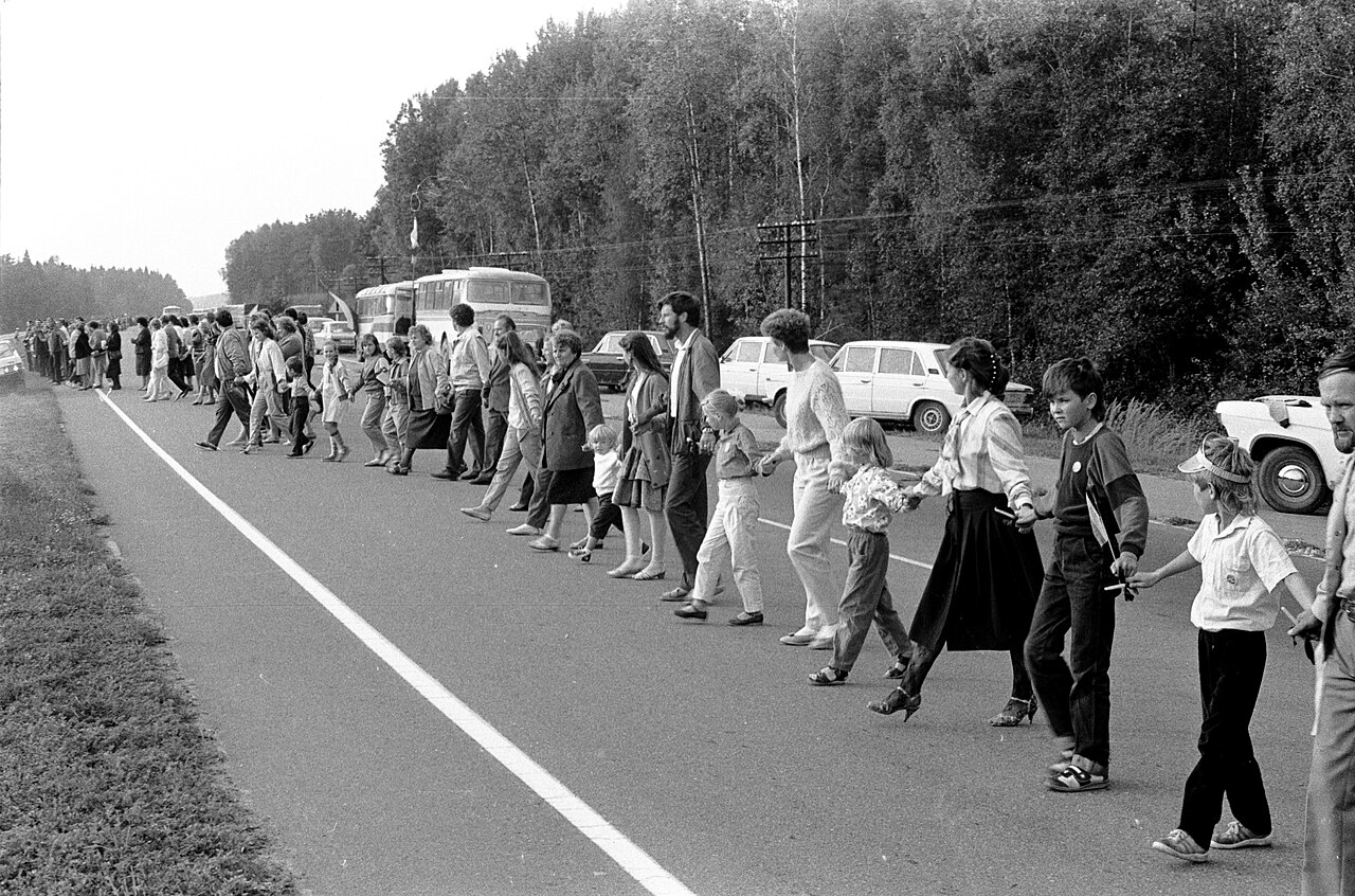
At 6:30 p.m. on Wednesday, 23 August 1989, people began taking their places beside Latvian roads. Instructions printed that morning in the regional newspaper Liesma were practical enough to sound almost ordinary: arrive half an hour early; stand on the correct side of the road; bring a radio; leave roughly 1.5 meters between people; use woven belts, ribbons, or other material where a sparse stretch opened to five meters.[4]
Then, at 7 p.m., the scheduled signal came through portable radios. Hands met. The planned interval was only fifteen minutes, from 7:00 to 7:15, but the intended line ran from Tallinn through Riga to Vilnius—across three Soviet republics and more than 600 kilometers. A gesture that lasted less than a television program required nearly six weeks of route design, transport, local publishing, traffic control, and political negotiation.[2][4][6]
The Baltic Way is often remembered from far above: a country-spanning ribbon and a crowd said to number about two million. The records are less geometrically tidy. UNESCO's register describes more than one million people and 600 kilometers; a Baltic cultural-heritage project says approximately two million but explicitly notes that an exact count cannot be recovered; Estonian Public Broadcasting's retrospective gives a route of more than 670 kilometers.[1][3][6] Those differences are not defects to be hidden. An open roadside action had no turnstiles, one census, or single surveyed measurement. Its historical achievement was not an audited total. It was the conversion of thousands of local arrivals into one visible political claim at one appointed minute.
The date made the route an argument
The action marked the fiftieth anniversary of the 23 August 1939 German–Soviet nonaggression pact and its secret protocol, which assigned Estonia and Latvia to a Soviet sphere of influence and dealt separately with Lithuania. Soviet forces occupied the three independent Baltic states in 1940, followed by coerced political incorporation into the USSR. In Baltic historical and political argument, exposing the secret agreement was therefore not antiquarian work: it challenged the legality of the political order in which the demonstrators still lived.[2][3][6]
By 1989, glasnost had widened the space in which that history could be discussed, but it had not settled the consequences. On 18 August, five days before the demonstration, Soviet official Alexander Yakovlev acknowledged in Pravda that the secret protocols were real. The Baltic popular movements pressed beyond recognition of the document to its political consequence: the joint action would condemn the pact, reject the legitimacy of occupation, and make renewed independence a public rather than merely diplomatic demand.[2][6]
Three mass organizations carried the project: Estonia's Popular Front, Latvia's Popular Front, and Lithuania's Sąjūdis. Representatives meeting in Pärnu on 15 July 1989 agreed to organize a common action. A further Baltic Council communiqué followed at Cēsis on 12 August. The surviving UNESCO collection also contains August letters to Latvian broadcasting officials, a press announcement, route documents, audio, film, and photographs. That paper trail matters because it refuses the easiest version of the story. The Baltic Way did not simply occur when a crowd discovered the same feeling. Institutions gave that feeling an address and a clock.[2][6]
A symbolic line became hundreds of assigned pieces
The endpoints were deliberately monumental: the foot of Toompea in Tallinn, the Freedom Monument in Riga, and Gediminas Tower in Vilnius. Between them, however, the route depended on places with no international fame—junctions, village roads, factory parking lots, fields, and long stretches where nearby residents could never supply enough bodies on their own.[1][2][3]
Organizers mapped a route through all three republics, then arranged buses to take participants to designated positions—especially along sparsely inhabited stretches where a local crowd could not close the distance. People did not merely travel toward the nearest capital. They were distributed across the road system so the three urban endpoints could plausibly become one action.[3][6]
A surviving Lithuanian organizer's memorandum shows the same political imagination working at ground level. It divided the route into fifty stages, one for each year since the pact, then moved immediately to gasoline, buses, food, medical help, temporary toilets, flags, and ways to fill empty spaces. Motorcyclists were considered as messengers between neighboring points. Candles and black ribbons could represent people killed during those fifty years and also occupy a physical gap. Symbol and logistics were not separate layers: the symbolism was designed to survive traffic, uneven population, and distance.[5]
Local newspapers completed the last mile. One Latvian notice sent participants from the Liepāja area on a roughly 220-kilometer journey to an assigned three-kilometer section near Bauska. It named the route, a bus stop for updated information, and contact points in Bauska and at kilometer intervals on the final approach. Readers were told to arrive by 6:30, carry cameras and radios, and form on the right side of the road after the broadcast signal. Another notice supplied the spacing rule and recommended belts or colored ribbons where people were scarce.[4]
This is the event's least cinematic but most consequential sequence: a cross-border decision became a national route; the route became regional allocations; the allocations became buses and workplace groups; the groups became named kilometers; the kilometers became intervals between individual bodies. Only after that descent through scale could a person reach out a hand and feel the international action beside them.
Radio synchronized a system it could not fully inspect
The radio cue solved one problem: three republics could share a start time without every local organizer reporting to one command post. The Latvian notices told people in advance to carry receivers and close the chain after the signal; the broader plan used radio broadcasts to coordinate participants assigned across the route.[4][6]
Radio did not solve distribution. Buses, designated positions, spacing, and ways to bridge shortages had to be settled before the signal arrived. Lithuanian planners contemplated shuttle buses, motorcyclists as messengers, and prepared ribbons or candles for gaps; Latvian instructions told participants which side of the road to occupy and how far apart to stand. A simultaneous action was possible because most decisions had already been pushed outward to local groups.[4][5][6]
Nor could one control room certify every meter. The event became knowable through converging traces: route plans and broadcast correspondence made before it, photographs and film made during it, and local press accounts and institutional records preserved afterward.[2][4] That is enough to establish a coordinated chain on an extraordinary geographic scale. It is not the same as a continuous instrument reading of the entire road.
Cars and buses delivered the participants, then occupied the same roads that had to display them. The archived photograph used for this article holds those two systems together: people stand along the Vilnius–Ukmergė motorway while vehicles mass beside them. The visible chain was inseparable from its transport network.[7]
“Unbroken” was a standard, not a measurement
Archival film and photography established the broad visual impression of a joined route. Local instructions also preserve anticipated thin sections and planned substitutes for missing hands, while the later ERR account calls the result a “nearly continuous” chain.[2][4][6] It is therefore safest to treat unbroken as an organizing standard and a successfully perceived public image, not as a claim that every meter was continuously verified for all fifteen minutes.
The same caution applies to participation. Later institutional accounts commonly use either “more than one million” or “about two million,” while national and news-agency estimates differ.[1][3][6] The lower figure is still an immense mobilization; the higher may be plausible without being precisely countable. What the record proves more securely is geographic reach: organizers assigned distant road sections in advance, broadcasts synchronized the action, and archival photographs document populated urban and rural segments.[2][4][6]
Nor did every hand have to encode an identical constitutional program. The three popular fronts issued a joint declaration seeking international support for restored independence, and the public action made that demand impossible to treat as the concern of a small circle.[2][3] It demonstrated shared rejection of the existing settlement and extraordinary support for self-determination; it could not inventory what every participant believed about timing, tactics, or the institutions that should follow.
What the line changed—and what it did not
The physical form of the Baltic Way carried a claim that a petition or one-city rally could not. It passed through cities, villages, workplaces, borders, and family groups. The route demonstrated that the popular fronts could coordinate transport, communication, and public participation across three republics. News and images traveled internationally, and later accounts locate the demonstration at the shift from demands for greater freedom within the Soviet system toward restoration of the three independent states.[2][6]
That does not prove a single event caused the political sequence that followed. It does show that historical argument, mass consent, and organizational capacity had become visible together. The Soviet authorities could dispute what independence meant or how it should proceed, but they could no longer plausibly treat Baltic coordination as local, private, or merely symbolic.[2][3]
The chain did not, by itself, restore three states. In December 1989, the Congress of People's Deputies of the Soviet Union declared the secret protocols legally null; Lithuania declared restored independence in March 1990; and the three Baltic states secured internationally recognized independence amid the Soviet collapse in 1991.[2][6] Later commemorative accounts sometimes arrange those events as an inevitable road from linked hands to freedom. The chronology supports a more bounded claim. The Baltic Way made mass consent, cross-border cooperation, and organizational capacity visible at a crucial stage; later legal acts, elections, confrontations, and the wider Soviet crisis still determined the outcome.
That boundary does not make the fifteen minutes smaller. It makes the achievement clearer. The memorable act was bodily and simple, but simplicity was the product, not the method. For five weeks, organizers decomposed an almost absurd proposal until villages, buses, newspapers, radios, ribbons, and assigned road markers could carry it. At 7 p.m., those pieces briefly disappeared into one line. History remembers the joining. The reconstruction reveals everything that had to be built before two hands could meet.
Sources
- UNESCO, “The Baltic Way—Human Chain Linking Three States in Their Drive for Freedom,” Memory of the World — register record and overview of the tri-national documentary collection.
- Estonian, Latvian, and Lithuanian National Commissions for UNESCO, Memory of the World Register Nomination: The Baltic Way (2008) — inventory of the Pärnu and Cēsis communiqués, radio and press records, photographs, recordings, and the action's chronology.
- The Baltic Way cultural-heritage project, “History” — account of the action's political purpose, organization, worldwide solidarity demonstrations, and why the exact participant total cannot be determined.
- National Library of Latvia, “Baltijas ceļš,” Digital Library — contemporary regional newspaper instructions on arrival, roadside placement, radio cues, spacing, ribbons, and parallel solidarity events.
- Military Heritage Tourism portal, “Memorandum for Baltic Way Organizers” — English presentation of Lithuanian planning notes on the fifty stages, transport, fuel, food, medical help, temporary toilets, and gap-filling.
- ERR News, “The Baltic Way: 35 years since 2 million protest for freedom from Soviets” (23 August 2024) — Estonian Public Broadcasting's reconstruction of the planning meetings, designated positions, buses, radio coordination, duration, estimates, and aftermath.
- Wikimedia Commons, “File:Baltic Way (Molėtai Region, Lithuania).jpg” — source page for Saulius Gruodis's 23 August 1989 Lithuanian State Central Archives photograph used as the article image.