The 1964 Alaska earthquake is often reduced to one superlative: the biggest earthquake in United States history.[1][4] That is true, but it is not yet an explanation. Size alone does not tell you why Anchorage lost blocks of buildings while some smaller structures stayed standing, why Seward and Valdez were torn apart by water and fire as much as by shaking, or why the event entered public memory as both an earthquake and a tsunami disaster.[1][2][3][4][5] The sharper historical question is what kind of catastrophe this actually was in real time.
The best answer is that the quake became several disasters at once. On the evening of March 27, 1964, a megathrust rupture near Prince William Sound shook southern Alaska for roughly four minutes, long enough to trigger different local failures in different terrains.[1][3][4] In Anchorage, multistory buildings, ground cracking, and above all landslides turned the city into a geology problem as much as a shaking problem.[1][2] Along the waterfronts of Seward and Valdez, submarine slope failures generated violent local waves while the earthquake was still in progress or immediately after it, destroying docks, fuel facilities, rail yards, and the practical life of the ports.[3][5] Then the broader tectonic displacement of the seafloor sent tsunami waves outward across Alaska and the Pacific.[1][4]
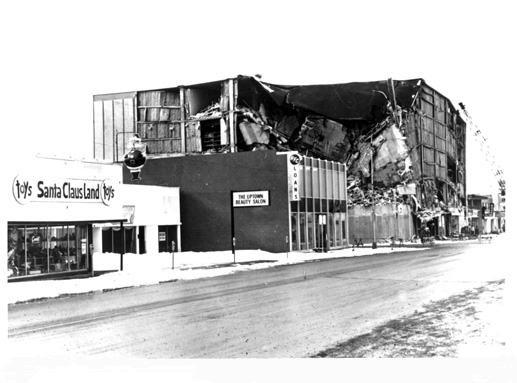
That sequence is why the cover image works.[6] The damaged J.C. Penney building in downtown Anchorage looks like classic earthquake wreckage, and it was. But it was only one layer of the event. The same evening also involved bluff collapses in Anchorage neighborhoods, rapid subsidence and harbor failure in coastal towns, and later-arriving tsunami waves that extended the catastrophe well beyond the initial shaking.[1][2][3][4][5]
Timeline anchors
- March 27, 1964, 5:36 p.m. local time: a magnitude 9.2 earthquake struck the Prince William Sound region of Alaska.[1][4]
- Roughly 3 to 4 minutes later: strong shaking ended, after prolonged motion had already destabilized bluffs, waterfront fill, and urban infrastructure across south-central Alaska.[1][3][4]
- During the shaking and immediately after it: slide-driven local waves and waterfront failure hit places including Seward and Valdez.[3][5]
- About 25 minutes after shaking stopped at Seward: longer-period seismic sea waves arrived and continued for hours, layering a wider tsunami disaster onto the earlier local destruction.[3]
- March 28, 1964: President Lyndon Johnson declared all of Alaska a major disaster area.[4]
1. The first clock was duration
The earthquake did not behave like a sharp jolt followed by cleanup. Official summaries emphasize the length of the motion because the length changed the kind of damage that became possible.[1][3][4] NCEI says the tremors lasted nearly five minutes, while the USGS historical summary gives an estimated duration of about three minutes and the Seward community study describes strong motion there lasting 3 to 4 minutes.[1][3][4] The exact count varies by source and location, but the historical point is stable: this was not brief shaking. It was long enough for weak soils, filled waterfronts, steep bluffs, and utility systems to keep failing while the earthquake was still unfolding.
That duration matters because it ties together places that otherwise look unrelated. The event began as a subduction-zone rupture, with the Pacific Plate driving beneath the North American Plate.[4] But people did not experience "plate convergence" in the abstract. They experienced specific materials giving way under repeated stress: urban clay bluffs in Anchorage, waterfront sediments in Seward, and unstable submarine slopes at Valdez.[2][3][5] One of the easiest mistakes in earthquake history is to treat all destruction as if it were caused by identical shaking. Alaska in 1964 was not that simple. The same regional rupture pressed on different local weaknesses and produced different local disasters.
2. Anchorage was a landslide city before it was a rubble city
Anchorage bore the heaviest property loss in the state, and the official studies are unusually clear about why.[1][2] The famous downtown damage photographs can tempt a reader into thinking the city was mainly a story of buildings losing a fight with seismic vibration. The USGS paper on Anchorage says otherwise. Direct vibration did heavy damage to multistory and large-floor-area buildings, but the most devastating damage came from ground cracks and landslides.[2] The city's destruction was concentrated where the earth itself translated, sagged, and broke apart.
The technical explanation in the USGS report is specific. Much of Anchorage sat above Bootlegger Cove Clay, a glacial estuarine-marine deposit with weak, water-rich, highly sensitive zones that failed under earthquake stress.[2] The most destructive slides moved on nearly horizontal slip surfaces, especially in the Fourth Avenue, L Street, Government Hill, and Turnagain Heights slide areas.[2] That sentence may sound geological, but it changes the historical reading of the city. Anchorage did not simply shake; in key places it slid.
The J.C. Penney image on the article is a good reminder of that distinction.[1][6] Official summaries note that the building was damaged beyond repair, but the same USGS and NCEI materials also stress that landslides and ground cracking damaged or destroyed about 30 blocks of dwellings and commercial buildings in Anchorage.[1][4] At Turnagain Heights, the largest Anchorage slide devastated around 130 acres and destroyed about 75 houses.[1] At Government Hill, the grade school became an emblem of how whole pieces of land had lost coherence.[1][6] Read this way, Anchorage's destruction was not only a skyline event. It was a bluff-failure event.
That is also why the city produced such uneven visual evidence. The damage photos themselves sometimes show ruined buildings standing beside comparatively intact ones.[6] The official explanation is not mystery but ground behavior. Some structures were hit mainly by shaking; others sat inside or beside moving slide blocks, grabens, or pressure ridges.[2] In historical terms, the city looked arbitrary because the ground was no longer acting like a stable platform.
3. Seward's disaster came from the waterfront failing under its own town
If Anchorage reveals what prolonged shaking could do to urban bluffs, Seward shows what the same earthquake could do to a port built on vulnerable waterfront sediments. The USGS community report states that, during the shaking, a strip of land 50 to 400 feet wide along the Seward waterfront slid into Resurrection Bay together with docks and harbor facilities.[3] Damage from strong ground motion itself was comparatively minor. The real catastrophe came from submarine landsliding, local waves, and then fire from burning oil tanks.[3]
This point is important because it restores sequence to what otherwise looks like general devastation. The waterfront did not merely get splashed by a tsunami after the earthquake. Parts of the waterfront physically failed first.[3] The same report says waves generated by these slides crashed ashore during the shaking, while broader seismic sea waves arrived about 25 minutes after the shaking stopped and continued for hours.[3] The town was therefore hit by more than one water event. First came slide-driven local destruction; then came the longer tsunami regime.
That double sequence explains why Seward appears in so many retellings as both a shaking site and a burned port. Once docks, tanks, rail facilities, and shoreline fill began to go, the economy of the town went with them.[3] The USGS report concludes that the harbor facilities were almost completely destroyed and that the town's economic base was effectively wiped out.[3] In other words, Seward was not only physically damaged. Its reason for existing as a year-round port was broken on the same night.
4. Valdez shows why local submarine slides mattered as much as the main tsunami
The worst tsunamis of 1964 were not all the same kind.[4][5] The USGS study of Valdez states the point cleanly: the deadliest aspects of the earthquake were the tsunamis it caused, and the worst of these were generated by local submarine landslides induced by the earthquake.[5] In Port Valdez, those slides produced high runups and engulfed the old town.[5]
That distinction matters because a casual memory of "the Alaska tsunami" can sound like one uniform wave front radiating outward from tectonic uplift. The historical record is more layered. There was a regional tsunami from broad crustal displacement, but there were also local slide-generated waves that behaved with far less warning time and much more violent concentration inside particular harbors and inlets.[4][5] The Valdez study draws on eyewitness reports, preserved film, post-tsunami surveys, and later geophysical work to reconstruct a delta-front failure that helped generate the local catastrophe.[5]
This helps explain one of the coldest features of the event: in some towns the water disaster was effectively simultaneous with the earthquake experience itself. NCEI notes that places such as Whittier were inundated before the earthquake had even fully subsided.[4] That sentence captures the historical problem better than any abstract model. For coastal communities near unstable submarine slopes, there was no clear line between "earthquake phase" and "tsunami phase." The two overlapped.
5. The final clock carried the disaster beyond Alaska
Only after those local failures does the wider Pacific story come fully into view. Both the USGS and NCEI summaries describe large-scale vertical displacement across southern Alaska and the continental shelf, with uplift and subsidence across enormous areas and tsunami waves propagating far beyond Prince William Sound.[1][4] The waves damaged the North American Pacific coast, reached Hawaii and Japan, and were recorded far from Alaska.[1][4] The disaster therefore escaped any purely local definition. A rupture off Alaska became a Pacific event.
This last clock is also why the earthquake left such a strong institutional afterlife. NCEI ties the event directly to the later development of the NOAA National Tsunami Warning Center in Palmer, Alaska.[4] That afterlife is historically revealing. The earthquake mattered not only because it destroyed communities, but because it exposed how little time some communities had once local slide-generated waves and broader tsunami propagation began. The state could not shorten the 1964 shaking. It could, however, build a better warning and monitoring system for future far-field tsunami risk.[4]
The bounded conclusion
The most useful way to remember the 1964 Alaska earthquake is not as one giant blow followed by cleanup.[1][2][3][4][5] It is better understood as a sequence of overlapping failures. Long shaking destabilized Anchorage's bluffs and utilities.[1][2][4] Waterfront sediments and submarine slopes failed at Seward and Valdez, producing local waves and harbor destruction while the event was still underway.[3][5] Then the broader tectonic displacement of the seafloor launched tsunami waves across Alaska and the Pacific.[1][4]
That layered sequence is what made the earthquake historically decisive. It turned geology into urban collapse, port failure, fire, and oceanic hazard all in one evening. The cover image shows only one frame of that history: downtown Anchorage after the ground stopped behaving like a foundation.[6] The larger event was wider, faster, and structurally stranger. One rupture produced several disasters, and people in different Alaskan towns entered different parts of that disaster almost at once.
Sources
- U.S. Geological Survey, "Largest Earthquake in Alaska" - official historical summary of the March 27, 1964 event, including magnitude, broad damage pattern, Anchorage losses, vertical displacement, and the wider tsunami footprint.
- Wallace R. Hansen, Effects of the earthquake of March 27, 1964, at Anchorage, Alaska (U.S. Geological Survey Professional Paper 542-A) - official community study explaining why Anchorage's worst damage came from ground cracks and landslides, especially in areas underlain by Bootlegger Cove Clay.
- Richard W. Lemke, "Effects of the earthquake of March 27, 1964, at Seward, Alaska" (U.S. Geological Survey) - official account of Seward's waterfront sliding, local waves, later-arriving tsunami activity, fires, and harbor destruction.
- National Centers for Environmental Information, "On This Day: Great Alaska Earthquake and Tsunami" - NOAA summary of the quake's duration, tsunami death burden, local inundation, Pacific reach, and the warning-system legacy that followed.
- Thomas E. Parsons et al., "Source and progression of a submarine landslide and tsunami: The 1964 Great Alaska earthquake at Valdez" (U.S. Geological Survey publication page) - on the local submarine landslide origin of Valdez's worst waves and the reconstruction of the old-town tsunami sequence.
- U.S. Geological Survey, "1964 Alaska Earthquake Damage Photos" - source page for the archival downtown Anchorage J.C. Penney building photograph used as this article's cover image.