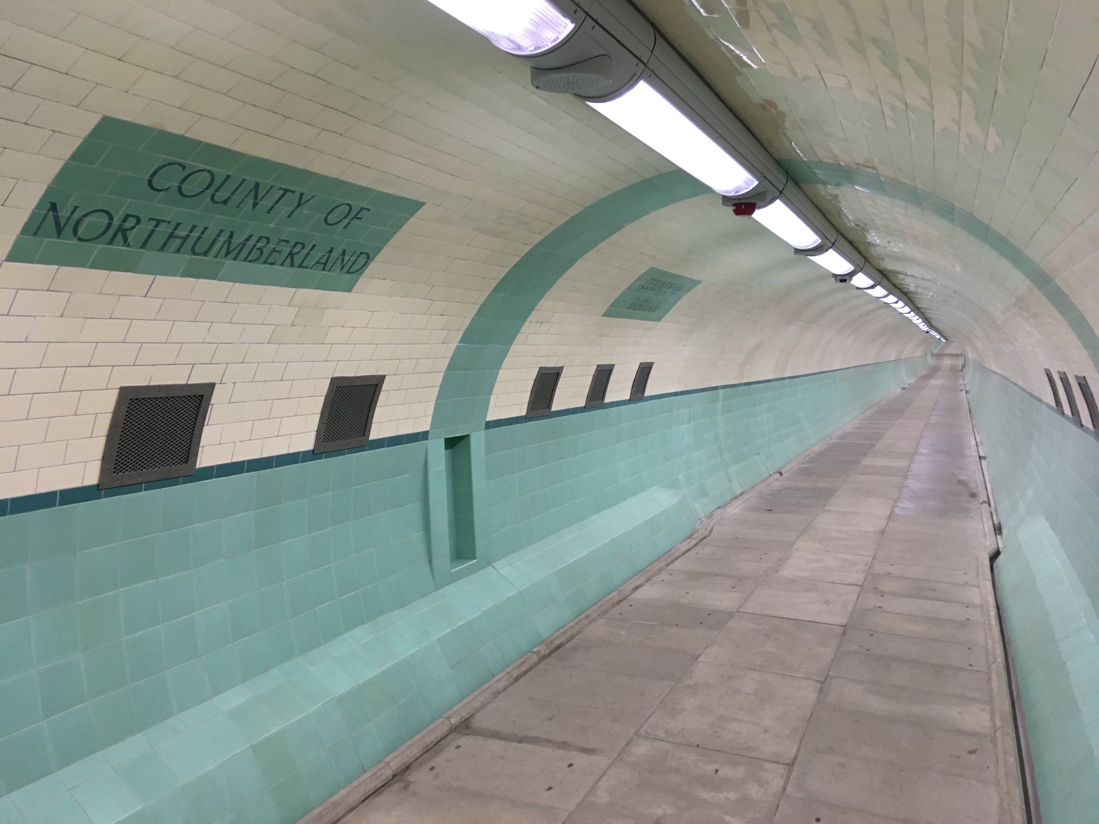
Tyneside usually explains its river with bridges. They turn the Tyne into skyline: arch, cable, traffic, reflection. Between Jarrow and Howdon, however, one crossing removes the view altogether. A circular brick entrance takes you down to two tiled tubes, one for feet and one for wheels, where the most important landmark is not the water but an old county line set into the wall.
That line is the reason to come. The Tyne Pedestrian and Cyclist Tunnels are not an abandoned passage or a themed industrial attraction. They remain a free working connection between South and North Tyneside, monitored and managed as transport infrastructure [1][3]. The useful visit respects that job: enter from the Jarrow side, take the pedestrian tube, pause at the boundary without stopping the flow, surface at Howdon, then return the same way.
Allow 45–60 minutes for the compact out-and-back. Aim for 10:30–12:00 on a weekday, after the stronger commuting pulse and before the day becomes an exercise in catching the last light. The anchor costs £0, needs no reservation and has no formal visitor queue [3][4]. Its vulnerable point is mechanical rather than popular: lifts and the tunnel itself can close for maintenance, so check the operator update linked from the regional authority's page on the morning you go. That authority page was last updated on 18 May 2026, providing the required recent confirmation that the crossing remains an administered Tyneside transport asset [1].
Begin at the south rotunda
The first local move is to start at Jarrow, not by asking a map for “Tyne Tunnel.” That phrase can send a visitor toward the cashless A19 road tunnels, which are a different system with a different entrance and toll logic. Save Tyne Pedestrian and Cyclist Tunnel — Jarrow entrance before leaving. From Jarrow Metro, allow roughly 15 minutes on foot as a planning margin; AccessAble identifies Jarrow as the nearest Metro station and Tyne Street as the approach to the south entrance [3].
Look for the low circular building rather than a dramatic portal. Historic England describes the entrance rotundas as red brick on blue-brick plinths, capped with shallow concrete shell domes [2]. Their scale is the first clue that this crossing was designed around repeated local movement, not ceremonial arrival. A ventilation chimney nearby supplies the recognition cue above ground; the local Fabulous North guide recommends watching for those chimneys at both ends [5].
The second move is to use a daylight window even though some listings promise broader access. The current AccessAble guide says the tunnels are open 24 hours a day, while North Tyneside's own visitor page says they are generally open 06:00–20:00, seven days a week, with a night service for shift workers [3][8]. Those public statements do not align. Treat neither as permission to improvise a midnight visit: follow the current operator notice, use the midmorning window, and abandon the plan if a closure is posted. This crossing is interesting enough without turning uncertainty into atmosphere.
There is usually no ticket line. A recent Tripadvisor review surface includes the memory of a former local who used the tunnel daily for work, while another visitor notes that the vertical lift felt tight with two e-bikes [7]. That is the queue reality in miniature: not a tourist crowd, but an occasional short wait behind people and machines for whom the crossing is part of a route.
Let the descent keep its age
Inside the rotunda, do not expect the preserved wooden escalator to carry you. The original Waygood-Otis machinery dates from 1951; the remaining wooden steps are retained as historic fabric, while lifts provide the working vertical connection [2][4]. Fabulous North's local account suggests descending the stationary escalator and using the lift at the far end, a sequence that makes the scale legible [5].
That is the third move, with a boundary: walk down the static escalator only if the route is open, signed for use and comfortable underfoot. The descent is about 60–61 metres long with a vertical rise of roughly 26 metres [4][5]. If stairs are difficult, or if you have a pushchair, wheelchair, luggage or bicycle, take the lift instead. AccessAble records a 100-centimetre clear door and a cabin approximately 110 by 200 centimetres for the vertical lift, as well as steep slopes between the lift areas and the level tubes [3]. “Step-free” does not mean friction-free.
The fourth move is to give working users the lift before treating it as part of your tour. After the 2019 restoration, the larger inclined lifts were designed to take up to six people with bicycles, while the vertical lifts were described as comfortable for two people with bikes [4]. Equipment state changes, as local reviews repeatedly demonstrate [6][7]. A cargo bike, mobility device or family group can consume the practical capacity quickly. Wait, keep the landing clear and never carry a bicycle down the historic wooden steps just to avoid a lift cycle.
Bring a light layer even in summer. Forty feet below the riverbed, the air and acoustics belong to an interior climate [4]. This is not a safety warning so much as a way to stay long enough to notice the tiled surfaces, the green dado band and the strange compression of distance without rushing back toward daylight.
Choose the tube before choosing the photograph
At the lower lobby, the system divides. The pedestrian tunnel is about 3.2 metres in diameter; the parallel cyclist tunnel is wider at about 3.7 metres [4][5]. Clear signs identify them [3]. The fifth move is simply to obey that split. Walkers take the pedestrian tube. Riders take the cyclist tube. If you are pushing a bicycle because you have become a pedestrian for the moment, follow current on-site direction rather than making a private interpretation at the mouth.
This sounds too obvious to count as local knowledge, but the local community record shows why it matters. In one r/NewcastleUponTyne discussion, a cyclist described heading toward the pedestrian tube before a CCTV operator corrected the mistake over a loudspeaker; other residents in the thread treated the echo, the separate lanes and the surveillance as ordinary features of the crossing [6]. The better behavior is to read the sign once and spare everyone the announcement.
Each level tube runs for roughly 270–275 metres [4][5]. At an ordinary pace, the crossing is short. Slow it without spreading out. The sixth move is to keep one side of the passage usable, make any photograph from the wall edge, and let faster walkers pass. Do not use the cyclist tube as a symmetrical portrait set, and do not test the echo with a shout. Sound carries well enough without help.
Halfway across, cream-and-green tilework marks COUNTY OF DURHAM on one side and COUNTY OF NORTHUMBERLAND on the other [2]. The seventh move is to stop just beyond the lettering, step tight to the wall, then turn back to read the join. The photograph at the top of this article shows the correct visual relationship: two ordinary tiled directions meeting beneath a river, not a grand border monument [9]. Make one frame and move.
The signs preserve an administrative geography older than today's North and South Tyneside. They also reveal what the tunnel was built to do. Work began after the 1946 Tyne Tunnel Act; the pedestrian and cyclist tubes were constructed from 1947 to 1951 and opened on 24 July 1951 as Tyneside's contribution to the Festival of Britain [2]. Their primary users were workers moving between shipyards, lead works and chemical works on both banks. Historic England records an average of 17,000 crossings a day, with a peak around 20,000 [2].
That history changes the meaning of the county marker. It did not tell leisure walkers that they had reached a quaint midpoint. It told a working population that a county boundary could be crossed as part of a shift. The tunnel made two banks operationally adjacent while keeping walkers and cyclists in separate streams. The street microcosm is not merely underground; it is an industrial commute condensed into tile, slope and lane discipline.
Surface, look back, then reverse the sequence
At Howdon, take the available lift up and clear the doorway before orienting yourself. The eighth move is to spend five minutes above ground looking back at the second rotunda and ventilation chimney before re-entering. This prevents the crossing from becoming a disembodied corridor. Two modest buildings, not a bridge deck, hold the river connection together.
For this tight visit, return through the pedestrian tube instead of adding a second attraction or an uncertain transit transfer. The repetition is useful. On the first crossing, the boundary arrives as discovery; on the second, you can watch the tile bands and slopes explain how the system manages direction. Keep the total visit within the planned hour so the tunnel remains the anchor rather than a novelty attached to a sprawling itinerary.
Cyclists should make the opposite choice: if the tunnel is part of a longer ride, keep moving into the signed network instead of stopping in the tube for a photo session. The restored crossing connects National Cycle Network routes 1, 14 and 72 [4][8]. Local Newcastle discussions describe it as a functional way to join river paths and commuting routes, not a cul-de-sac [6]. Walking visitors borrow that infrastructure briefly; they do not set its pace.
Four mistakes that flatten the crossing
Mistake one: following signs for the road tunnel. The A19 crossing and the free pedestrian-cyclist system share a name but not an entrance or payment model. Better: pin the Jarrow pedestrian entrance and look for the circular brick rotunda, not a traffic lane [1][2].
Mistake two: arriving for a ride on the wooden escalators. Their value is that original machinery and steps survive, not that they operate as an attraction [2][4]. Better: use them only as a signed stationary descent if able, and take the working lift when access or equipment requires it.
Mistake three: treating the county line as a private photo set. The midpoint is still inside a working corridor whose two tubes exist to separate movement [3][6]. Better: step aside, frame once and let the old border remain permeable.
Mistake four: trusting a generic opening-hours snippet. Public listings currently disagree, and lift maintenance can change the practical route [1][3][8]. Better: check the operator update on the day, go in the 10:30–12:00 window, and leave if access is uncertain.
The concrete plan is small. Spend £0 at the anchor. Reserve nothing. Allow 45–60 minutes, including a roughly 15-minute approach from Jarrow Metro, two level crossings and five minutes above ground at Howdon. Carry a light layer, keep the correct tube, give lifts to those who need their capacity, and pause at the county tiles without occupying the line.
Tyneside's bridges make the river visible. This tunnel does something subtler: it makes the old river economy visible through absence. There is no water to admire underground, only the infrastructure that let thousands of people pass beneath it. At the midpoint, Durham and Northumberland still meet in glazed letters. The best local move is also the simplest one—notice the border, then keep walking.
Sources
- North East Combined Authority, “Tyne Tunnels” — current ownership and management context for the pedestrian and cyclist crossing; page last updated May 18, 2026.
- Historic England, “Tyne Pedestrian and Cyclist Tunnels” — official Grade II list entry covering the rotundas, tilework, county signs, construction, industrial commuting history and surviving machinery.
- AccessAble, “Tyne Pedestrian and Cyclists Tunnel — Jarrow — South to North” — detailed access survey covering approach, stated opening, lift dimensions, slopes, signs, CCTV and separate tubes.
- Walk Wheel Cycle Trust, “Tyne Pedestrian and Cyclist Tunnels reopen after six years” — restoration record with tunnel dimensions, depth, lift capacities, free access and National Cycle Network connections.
- Fabulous North, “Tyne Cyclist and Pedestrian Tunnels” — local guide and field account of the Howdon and Jarrow entrances, stationary wooden escalators, tunnel dimensions, county marker and ventilation chimneys.
- r/NewcastleUponTyne, “Pedestrian Tyne Tunnel” — local community discussion of the two lanes, CCTV correction, echo and everyday use; treated as anecdotal field evidence.
- Tripadvisor, “Tyne Pedestrian & Cycle Tunnel” — current review surface, including a review published in February 2026 and visitor reports on daily local use, quiet periods and lift constraints.
- Visit North Tyneside, “Tyne Pedestrian and Cyclist Tunnels” — local authority destination page with general-hour guidance and National Cycle Network route references.
- Wikimedia Commons, “Tyne Cyclist and Pedestrian Tunnel, Subterranean County Boundary” — Anthony Foster's 2020 real photograph, original dimensions and CC BY-SA 2.0 provenance for the cover image.