Stockholm gets sold too often through rooftops and museum islands. The cleaner local evening move is narrower: take Mariaberget for one half-kilometer ridge walk, let Monteliusvagen do the moving, and let Ivar Lo's Park do the sitting. The path gives you the long western read over Riddarfjarden, City Hall, and Riddarholmen; the park gives you the quieter pause once the rail-side walkway starts filling with sunset stoppers.[1][2][3]
That division matters because Monteliusvagen is short by design. Visit Stockholm describes it as a 500-meter walking path; a local Stockholm guide measures it at 416 meters, running from Kattgrand to Skolgrand with terraces and benches along the way.[1][4] In other words, this is not a hike and not a checklist district. It is one ridge edge, best used for 60 to 90 minutes around blue hour rather than as a full night program.
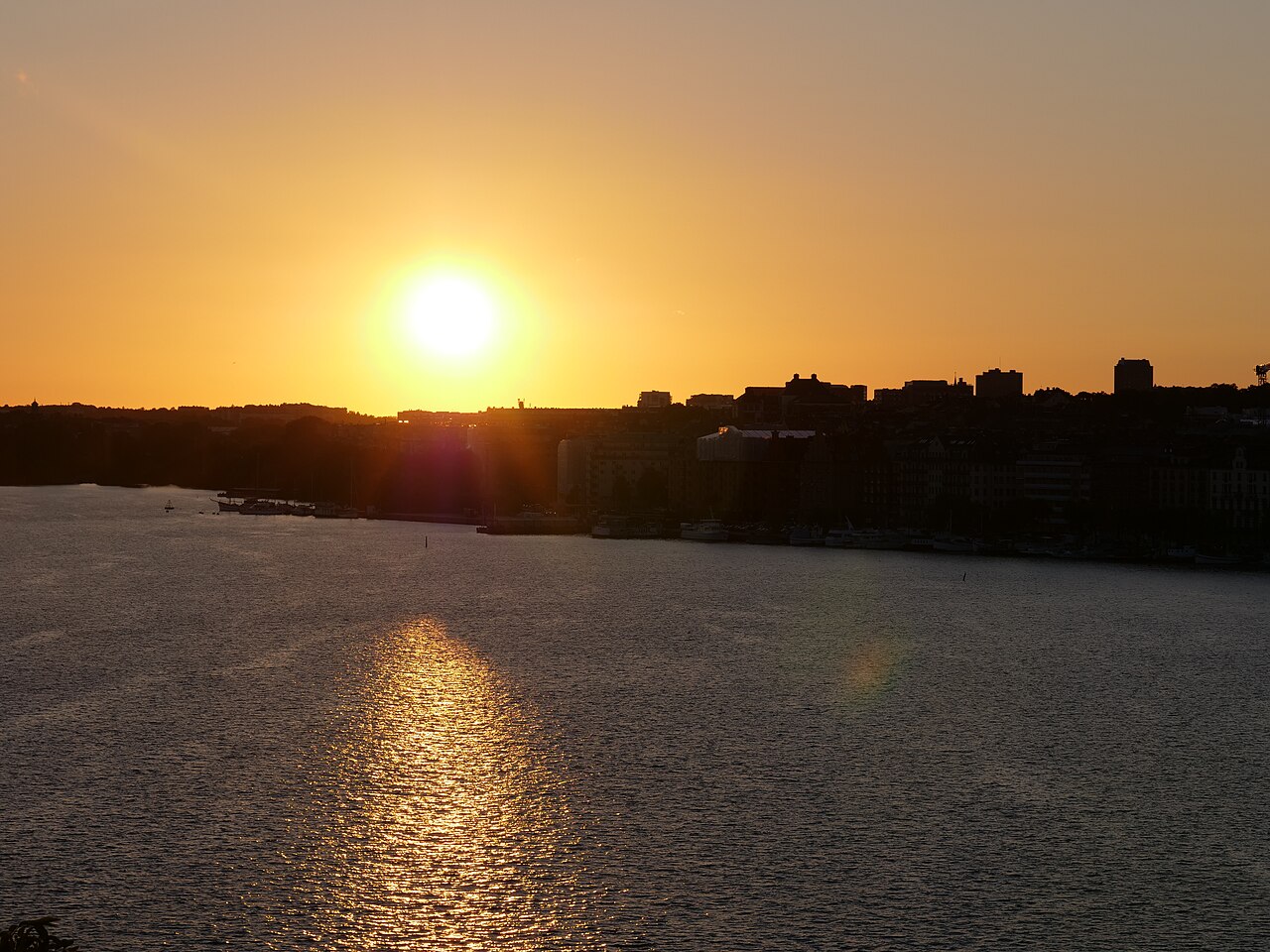
The cover image locks the atmosphere correctly. It is a documentary sunset photograph made from Monteliusvagen in August 2017, looking back toward central Stockholm.[7] What the image gets right is proportion: this part of Sodermalm is not about height alone, but about the slow opening of water, masonry, and church spires as the light drops.
The night-room sequence in one line
- Monteliusvagen for the moving vantage.
- Ivar Lo's Park for the seated landing.
Do them in that order and the ridge stays legible.
Anchor 1: Monteliusvagen should stay in motion
Monteliusvagen is strongest when you treat it as a walking edge rather than a place to camp. The official Stockholm page calls out the path's big view over Lake Malaren, City Hall, and Riddarholmen, especially at sunrise and sunset, and also adds a practical warning: parts of the path can get slippery in winter.[1] The fresh March 11, 2026 best-views guide from Visit Stockholm pushes the same point from another angle, grouping Monteliusvagen and Ivar Lo's Park together as popular places for weekend walks and sunset picnics.[3]
The local approach that keeps the evening clean is to start from Mariatorget rather than arriving cold at the middle of the ridge. View Stockholm's local guide says the easiest access is via the red-line metro to Mariatorget, then uphill through Blecktornsgrand toward the path.[4] Budget about 8 minutes from the station to the ridge entrance and another 7 to 10 minutes to walk the full path without turning the route into a bench-by-bench stop.
The point is directional. Enter from the eastern side, walk west, and let the skyline open gradually instead of revealing everything at once. If you start around 35 to 45 minutes before sunset, the first pass still has color in the buildings, and your second pass can happen once the water starts carrying lights from Kungsholmen and the old center.
Anchor 2: Ivar Lo's Park is where you actually stop
Ivar Lo's Park works because it absorbs the pressure that Monteliusvagen creates. Visit Stockholm calls it one of the city's most beloved public parks and still a hidden gem, a place that also serves as a great viewpoint and a strong spot for a summer picnic.[2] A local Stockholm viewpoints guide goes further and says plainly that if you want a picnic or even a small barbecue on this ridge walk, the park is the right place to do it.[5]
This is also where Mariaberget stops feeling like anonymous scenery. Stockholmskallan, the Stockholm city history archive, places settlement here as far back as the 1300s and explains that many of the surrounding houses were once marked for demolition about 100 years ago before preservation policy stepped in.[6] That history is the local texture the viewpoint needs. You are not looking out from a neutral terrace. You are standing inside an old residential ridge that survived because the city eventually chose conservation over replacement.
In practical terms, the park is only about 3 minutes off the main Montelius flow if you are already on Bastugatan, and it gives you the better sit-down geometry: lawn, benches, and space to look back without blocking the path.[2][5] The article's core bet is simple. Use Monteliusvagen for the slow reveal, then shift to Ivar Lo's Park before your body language turns the railing into a traffic problem.
8 local moves that make the evening work
First, start from Mariatorget and walk uphill. The route reads better when the ridge arrives gradually instead of appearing all at once from a taxi or random drop-off.[4]
Second, use Monteliusvagen as a moving pass first and a photo pass second. The path is short enough that stopping immediately weakens the sequence.[1][4]
Third, aim for a 35-45 minute pre-sunset arrival. That gives you one warm-light pass and one blue-hour pass without rushing.
Fourth, walk east-to-west. The view feels bigger when it opens in stages toward Riddarfjarden and City Hall.[1][3]
Fifth, keep your longest sit-down for Ivar Lo's Park, not the rail edge. The park is the city's quieter picnic room on this ridge.[2][3][5]
Sixth, if you are carrying takeaway coffee, buy it before the climb at Mariatorget and keep the ridge itself friction-light. The walk is only about 15 to 20 minutes end to end with pauses; you do not need another stop layered inside it.
Seventh, on weekends, expect the benches closest to the view to fill first. If the rail line starts clogging, move to the park lawn or the secondary benches instead of waiting for a perfect opening.[2][3][5]
Eighth, in colder months, take the official slippery-path warning seriously. Smooth-soled shoes make this route worse than it needs to be.[1]
Non-local trapline: 3 common mistakes and the better alternative
Mistake 1: treating Monteliusvagen like a static sunset platform
Better alternative: make one full walking pass first. The ridge is too short to surrender immediately to one railing slot.[1][4]
Mistake 2: arriving exactly at sunset and expecting calm
Better alternative: arrive 35 to 45 minutes early, then let the second half of the route happen in blue hour when the first photo rush starts thinning.[3][5]
Mistake 3: using the path itself as the picnic zone
Better alternative: shift the sit-down to Ivar Lo's Park, which is the more natural landing place for food, drink, and longer pauses.[2][5]
Concrete go details
- Best window: start the climb from Mariatorget about 35-45 minutes before sunset; total useful time on the ridge is about 60-90 minutes.
- Expected spend: SEK 0 if you are only walking; SEK 45-80 if you add takeaway coffee before the climb.
- Queue reality: no tickets and no reservations; the only bottleneck is shared space at the rail edge during warm-weather sunsets.[3][5]
- Where to stand or sit: stand for the first pass on Monteliusvagen, sit for the longer pause in Ivar Lo's Park.[1][2]
- Navigation cue:
Mariatorget metro -> Blecktornsgrand -> Kattgrand/Monteliusvagen -> Bastugatan 26 for Ivar Lo's Park.[2][4] - Numeric anchors worth remembering: 500 meters official path length, 416 meters in the local guide, about 8 minutes from Mariatorget to the ridge, about 3 minutes from the path to the park, and about 15-20 minutes to walk the full sequence without a long sit-down.[1][2][4]
- Place-specific texture: this viewpoint sits on Mariaberget, a residential ridge with roots going back to the 1300s, and the old houses around it were preserved rather than razed in the twentieth century.[6]
Stockholm rewards long daylight, but this particular move does not need much of it. One short ridge, one quieter lawn, and one disciplined handoff between the two are enough to make the city feel lived in rather than merely looked at.
Sources
- Visit Stockholm, "Monteliusvagen" - official page noting the 500-meter ridge path, main sightlines, and winter slipperiness warning.
- Visit Stockholm, "Ivar Lo's Park" - official page describing the park as a hidden-gem viewpoint and picnic spot on Mariaberget.
- Visit Stockholm, "Guide to the Best Views in Stockholm" (published March 11, 2026) - recent confirmation that Monteliusvagen and Ivar Lo's Park remain core weekend-walk and sunset-picnic viewpoints.
- View Stockholm, "Hitta basta utsikten i Stockholm" (updated April 12, 2024) - local guide giving Monteliusvagen's 416-meter measure and the Mariatorget/Blecktornsgrand approach.
- The Best Viewpoints, "The best Stockholm viewpoints - Tips from a local" (last updated March 24, 2026) - local guidance on doing Monteliusvagen at sunset and using Ivar Los park for the picnic stop.
- Stockholmskallan, "Ivar Los park" - Stockholm city history archive page on Mariaberget's older housing stock, preservation history, and long settlement timeline.
- Wikimedia Commons, "File:Sunsets of Stockholm from Monteliusvagen 01.jpg" - documentary sunset photograph used for the cover image.