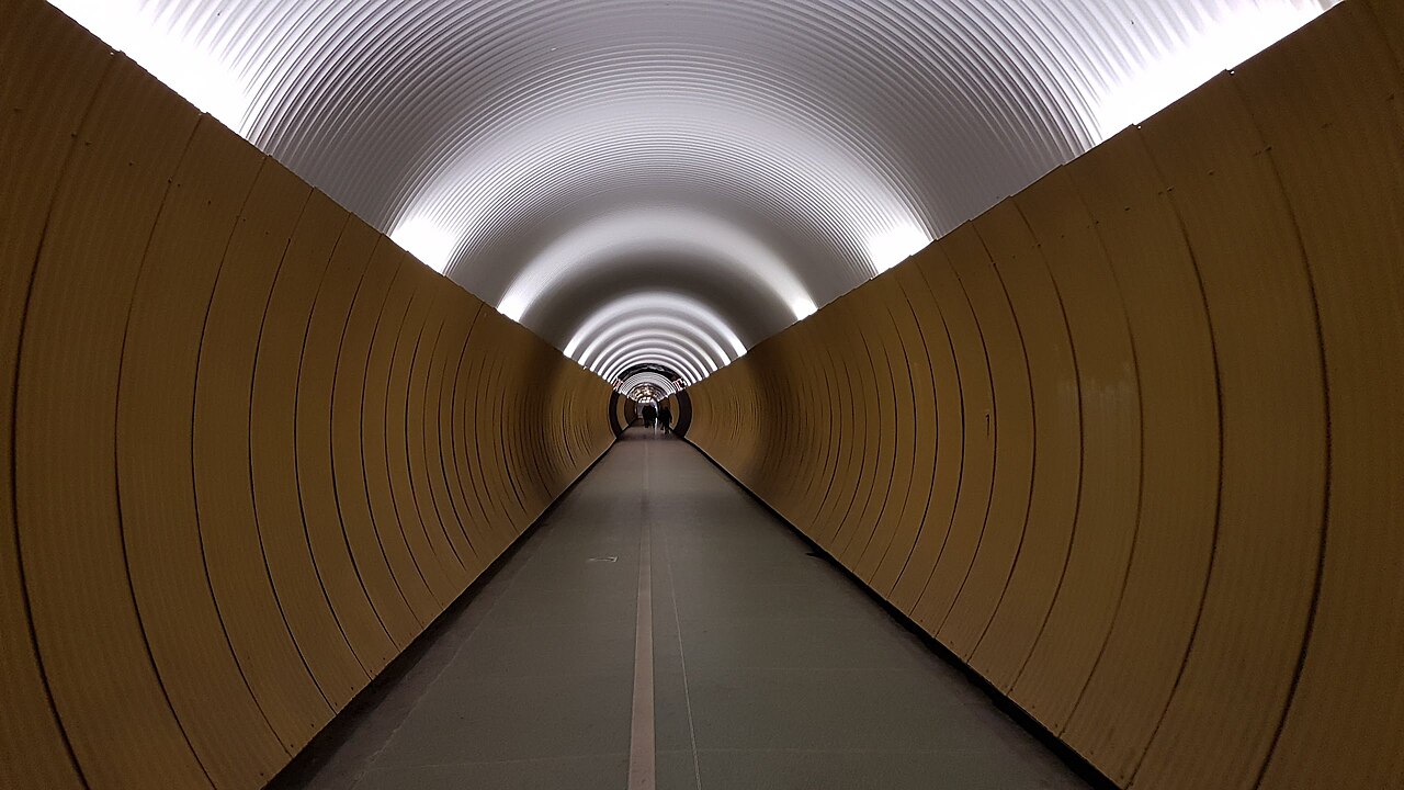
The photograph invites you to stand in the middle. Yellow panels narrow toward a vanishing point, lights repeat overhead, and the floor seems to offer a straight line into the frame. In Stockholm’s Brunkeberg Tunnel, that tempting camera position is also someone else’s route across town. The image makes a corridor look still; its daily purpose is movement.[1][8]
The passage runs 231 metres between Tunnelgatan and David Bagares gata, carrying pedestrians and cyclists through the ridge between the Hötorget side of central Stockholm and Östermalm.[1] A November 2025 Google review makes a useful distinction: enjoy the unusual short walk when nearby, but temper expectations of a major attraction.[2] Build it into a journey that already needs to cross the hill. Its interest grows when you understand what it saves.
Find the door below the climb
Approach from Sveavägen into Tunnelgatan, aiming for Tunnelgatan 1A; the opposite end is at David Bagares gata 5.[1][3] At the western approach, look for the tunnel entrance below the stairs. Those two choices explain the site before any historical account does: the street can rise, or you can pass through the obstacle.
Set your map to the entrance on the side you are approaching from. A pin in the middle of the passage is less useful when the important choice is between going up and going through. At the eastern end, David Bagares gata carries you back into the street network.[1][3]
For a leisurely look, I suggest 10:00–12:00 on a weekday, comfortably between the usual commuting peaks. That is a planning choice, not a measured quiet period. Allow 15–25 minutes for the approaches, crossing and a brief look back; someone simply getting through will need much less. There is no ticket reservation or visitor queue to join: this is a free public passage.[3] Budget SEK 0–50 excluding transport, with zero covering the entire crossing and the upper end merely an optional refreshment allowance, not a quoted price.
Read the floor before the photograph
The tunnel is only 4 metres wide.[3][4] Before entering, identify the marked pedestrian portion and stay within it. If you want a photograph, look behind you before stopping and keep clear of both the cycle lane and the doorway. Let a gap in traffic determine the moment. A photograph taken a little off-centre costs less than making everyone negotiate around your perfect symmetry.
This is more than generic pavement etiquette. In a March 2025 response to a proposal about pedestrian access, Stockholm’s traffic office acknowledged the tunnel’s constrained width. It nevertheless argued that the passage remained important to both walkers and cyclists and should continue serving both. The report also recorded complaints about automatic doors whose operation had been difficult to maintain after vandalism.[4] A door opening smoothly in one visitor’s account is therefore a poor basis for promising effortless access on another day.
The first trap is treating an attractive corridor as a photo studio. The second is treating an opening door as proof of unrestricted hours. A June 2025 Google reviewer reported a door responding before the posted opening time, but chose not to enter.[2] Follow the posted schedule instead. Listings checked September 16, 2026 give 06:00–22:00 daily, matching the hours documented by local magazine Situation Sthlm.[2][3] Leave a margin before closing if your return depends on this shortcut.
The ridge is still there
Behind the smooth visual rhythm lies an awkward piece of ground. Construction began in 1884, and the passage was completed in 1886.[1] Stockholmskällan, the city’s historical resource, describes the problem facing engineer Knut Lindmark: loose material and the risk of collapse complicated excavation. A freezing machine obtained from England made it possible to freeze the gravel, dig forward and cast the walls.[5]
That changes the reading of the yellow interior. Its apparent simplicity conceals the work needed to hold a path through the ridge. Local newspaper Mitt i supplies a particularly good looking instruction: notice the rock exposed near the middle of the passage.[6] Glance up while keeping your walking line predictable. The ground that disappeared from your route has not disappeared from the city.
For more context, look up the museums’ Historiska vandringar before setting off. Mitt i’s May 2026 guide still lists Brunkebergstunneln among the free historical audio walks.[7] Its earlier reporting explains that the guides combine narration with old photographs and can also be explored from home.[6] Previewing those images outside the tunnel gives the crossing more depth without turning the narrow passage into a place to stand scrolling.
Come out with a different sense of distance
At the far end, clear the doorway before turning around. If stairs suit you and you have time, one Google reviewer suggests passing underneath in one direction and returning over the hill.[2] Keep that as an optional comparison rather than a requirement; the direct route has particular value precisely because it avoids the ascent.
Either way, take one final look at the two street levels. The most revealing souvenir is the small correction to your mental map: Stockholm contains a hill here, and generations of ordinary journeys have found a way through it.
Sources
- Visit Stockholm, “Brunkebergstunneln” — official local visitor information on the 231-metre route, entrance streets, construction dates and photographic popularity; checked September 16, 2026.
- Google visitor reviews reproduced on Wanderlog, “Brunkeberg Tunnel” — Neh C, April 19, 2025; Nola, June 25, 2025; Lizaveta K, November 17, 2025. Route choices, posted hours and visitor expectations; individual reports are not guarantees.
- Situation Sthlm, “Stadens undergångar,” issue 233, January 2017, p. 32 — local reporting on the tunnel’s addresses, dimensions, free passage and opening hours; present-day hours cross-checked against source 2.
- Stockholm Trafikkontoret, “Förbättra framkomligheten för gångtrafikanter i Brunkebergstunneln,” March 5, 2025, prepared for the May 22 traffic committee meeting — width constraints, continued pedestrian and cycle access, and automatic-door complaints.
- Stockholmskällan, catalogue description of Birger Kock and Fredrik Schütz, “Knut Lindmark: En pionjär inom kommunikationstekniken,” Tekniska museet, 1973 — the city’s summary of excavation difficulties and ground freezing; accessed September 16, 2026.
- Mathilda Nilsson, Mitt i, “Utforska Stockholms förflutna – direkt i din mobil,” September 20, 2024 — on-site museum reporting, exposed rock in the tunnel, and audio guides incorporating historical photographs.
- Rebecca Folkesson, Mitt i, “Upptäck Stockholms förflutna – direkt i luren,” May 8, 2026, updated May 13 — recent local confirmation that Brunkebergstunneln remains in the museums’ free historical-walk programme.
- Fringilla, “Brunkebergstunneln 2018,” Wikimedia Commons — original photograph taken March 17, 2018, released under CC0; reproduced above.