Split gets flattened too easily into one long waterfront drift: palace, Riva, gelato, another square, then some vague promise that Marjan is "nice at sunset" if you still have energy left. The cleaner first-evening move is shorter and more local in its logic. Start at Matejuška, cut uphill through Veli Varoš, take the first Marjan lookout at Prva Vidilica while the harbor is still legible, then come back down to the same port once the lamps and masts take over. The official Split Tourist Board materials already imply that sequence: Matejuška as the old port of Varoš, Saint Francis and the lower Varoš seam as the natural start, and the first famous viewpoint above the neighborhood as the earliest moment when Split opens fully without turning the outing into a hike.[1][2][5]
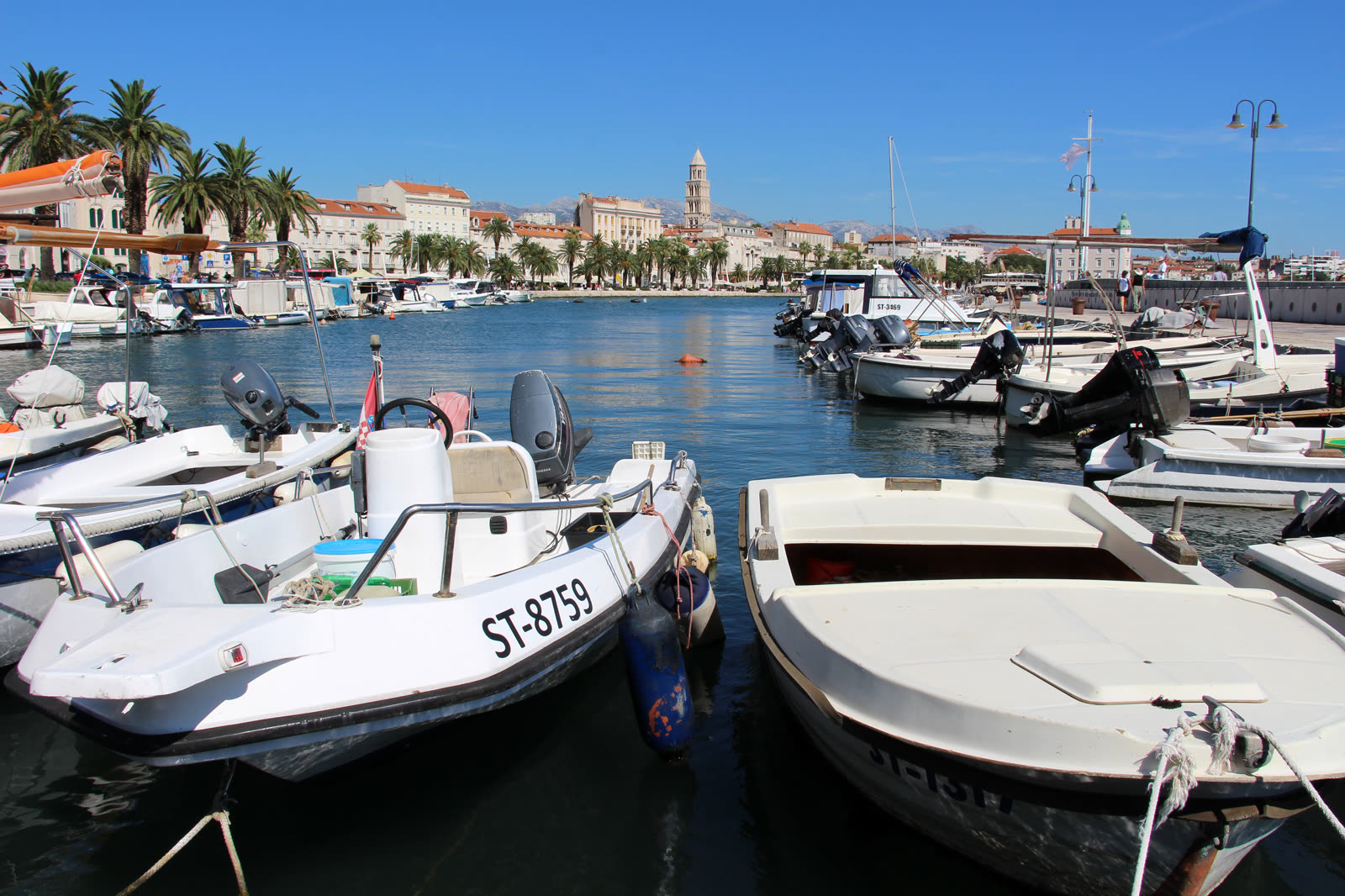
The scale is what makes the ritual work. Split's tourist board calls Marjan the hill that makes people describe the city as a "city under Marjan," notes that it is only about 180 metres high, and says the peninsula runs about 3.5 kilometres long and 1.5 kilometres wide, with peaks at 125, 148, and 178 metres above sea level.[1][3] That is large enough to organize the city, but small enough that a visitor does not need to conquer the whole forest to get the point. Matejuška supplies the lower half of the sentence. The same tourist-board page describes it as a centuries-old small-boat port of Veli Varoš, still lined with tied boats, drying nets, bait preparation, and the giant fish-hook monument that salutes local fishermen.[2]
The neighborhood between those two anchors matters just as much. Total Croatia's Veli Varoš note places the quarter directly above Trumbićeva obala on Marjan's southern slope and describes it as the old fishermen-and-farmers labyrinth that still feels more like a village than a polished urban district.[5] That is why this route lands better than a generic "go up Marjan sometime" instruction. You do not teleport from palace tourism into nature. You pass through the old working suburb that historically connected the port below to the hill above.
Image context: the cover uses a real Wikimedia Commons documentary photo of Matejuška. That is the right recognition cue because this article is not asking the reader to chase the biggest panorama in Split. It is asking for one old port, one uphill seam, and one measured return.[9]
Why the first viewpoint is enough for a first evening
The official "In Search of Soul of Split" route is useful precisely because it does not start with a grand summit claim. It starts at Saint Francis on the Riva, sends the walker uphill through Veli Varoš, and tells them to stop at the viewpoint with the most photographed view over Split and at the old Jewish cemetery founded in 1573.[1] That first payoff is enough for a first evening. By then the harbor has spread out below you, the palace core has compressed into stone mass, and the relationship between the port, the suburb, and the hill is already clear.
Going farther west into Marjan can be wonderful, but it changes the shape of the outing. Once you continue deeper, the city read starts turning into a park walk, then into a longer recreational commitment. The recent local answer on r/Split is revealing here because it reduces the advice to exactly the right scale: Marjan at sunset, wandering Varoš, Split as vibe rather than checklist.[6] That is essentially this ritual. Climb only until the city clarifies, then stop adding tasks.
Current access conditions make the short southern seam even smarter. Split's May 1, 2026 visitor-access notice says the northern side has reopened in part, but works continue, visitors should use extra caution, the narrower Bena area remains closed, and the firebreak road plus paths leading to it remain shut.[4] None of that blocks the Matejuška-Varoš-Prva Vidilica line. It does mean a first-time visitor should resist the urge to wander blindly deeper into Marjan just because the hill looks modest from below. The southern seam is both the historically correct read and the cleaner current one.[4]
8 local moves that make this ritual land
- Start at Matejuška, not in the middle of the Riva. The old port gives the evening a working edge before it becomes a view.[2]
- Use Saint Francis and the western end of Trumbićeva obala as the lift-off point. Both the official route article and the Veli Varoš profile treat that seam as the natural entrance into the neighborhood.[1][5]
- Aim for roughly 60 to 90 minutes before sunset. That gives Varoš real texture in the climb and keeps the harbor readable when you reach Prva Vidilica.[1][6]
- Let the first viewpoint be the goal. For a short visit, Prva Vidilica and the Jewish-cemetery edge do the essential work without pushing you into a deeper Marjan commitment.[1][8]
- Read the city twice. First from above at the viewpoint, then again back at Matejuška after dusk, when the boats and lamps take over from the broad panorama.[2][7]
- Use the Marjan Visitor Center only as a utility stop. If you want a same-day map or access clarification, it sits at
Trumbićeva obala 18and works Monday to Friday, 07:30-15:30.[3] - Respect the 2026 closure logic. Bena and the firebreak-linked paths remain restricted, so do not improvise deeper north-side detours late in the day.[4]
- If the bura is up, shorten the ritual rather than forcing it. Local advice in spring still warns that Split can feel colder than the air temperature suggests once the wind turns sharp.[6]
Non-local trapline: 4 common mistakes and the better alternative
Mistake 1: staying flat on the waterfront because Marjan feels like "something for tomorrow"
Better alternative: go up immediately through Varoš. The hill is part of Split's first reading, not an optional nature annex.[1][3][5]
Mistake 2: treating Marjan like a summit project and walking too far on a short evening
Better alternative: stop at the first lookout. The point is to understand the seam between port, neighborhood, and hill, not to complete the peninsula.[1][6][8]
Mistake 3: wandering into restricted or work-affected areas because the forest looks open from a map thumbnail
Better alternative: keep to the southern old route and check the current access notice if you want to extend farther north or west.[4]
Mistake 4: arriving after dark and asking the climb to do all the work
Better alternative: give yourself some last light on the way up. The ritual depends on watching Split change from stone and harbor detail into lamp pattern, not on starting with a black hill and a finished skyline.[1][6]
Concrete go details
- Best window: start the climb about 60 to 90 minutes before sunset, reach Prva Vidilica with light still on the harbor, and be back at Matejuška by blue hour.[1][6]
- Expected spend: 0 euros if you keep the ritual to public space and your own water; the route itself has no ticket layer.[2][3]
- Queue and reservation reality: none; only the Visitor Center keeps weekday service hours of 07:30-15:30.[3]
- Where to stand: first on the stone edge at Matejuška to read the boats, then at the first open south-facing rail or wall at Prva Vidilica, then back at the port once the lamps come on.[2][7][8]
- Navigation cue:
Matejuška -> Saint Francis -> western Trumbićeva / Veli Varoš stairs -> Prva Vidilica and the Jewish-cemetery edge -> same seam back down -> Matejuška.[1][5][7][8] - Numeric anchors worth keeping: 180 metres, 3.5 kilometres, 1.5 kilometres, 125 / 148 / 178 metres, 1573, 1852, 1903, 07:30-15:30, and May 1, 2026.[1][3][4]
Split has bigger panoramic claims than this one short evening seam. It also has louder nightlife scripts and more obvious checklist monuments. Very few of them explain the city as efficiently. Start at the old fishermen's edge, climb until the harbor opens, then descend before the outing hardens into a mission. The city will have said enough.
Sources
- Tourist Board of Split, "In Search Of Soul of Split" (official route essay describing Split as a "city under Marjan," Marjan's roughly 180-metre scale, the Saint Francis start, the first major viewpoint above Veli Varoš, and the Jewish cemetery founded in 1573).
- Tourist Board of Split, "Matejuška port" (official page covering the centuries-old fishermen's port of Veli Varoš, the tied boats and nets, the fish-hook monument, and Matejuška's continuing social life).
- Tourist Board of Split, "Marjan" (official page covering Marjan's 3.5-kilometre by 1.5-kilometre scale, the 125/148/178-metre elevations, the 1852 forestation effort, the first pines in 1903, and the Visitor Center hours at Trumbićeva obala 18).
- Tourist Board of Split, "IMPORTANT NOTICE - Visitor Access in Marjan Forest Park" (current 2026 access note covering the May 1 reopening on part of the north side, continued caution, the Bena closure, and the firebreak-path restrictions).
- Total Croatia, "Two Charming Old Neighborhoods: Veli Varoš and Radunica" (local guide describing Veli Varoš as the old fishermen-and-farmers quarter above Trumbićeva obala, with stone lanes and multiple easy access points).
- Reddit / r/Split, "Questions from a tourist" (posted March 2026; recent local/community advice pointing visitors toward Marjan at sunset, wandering Varoš, and caution around Split's spring wind).
- Google Maps search, "Matejuska Split" (current local place layer used here as a live orientation and same-day activity check for the port edge).
- Google Maps search, "Prva Vidilica na Marjanu Split" (current local place layer used here for the first-viewpoint label, recent photos, and same-day route confirmation).
- Wikimedia Commons, "File:Split - Matejuška (49023896673).jpg" (documentary source page for the lead photograph used in this article).