Singapore gets flattened too easily into skyline shorthand. Visitors do Marina Bay as a backdrop, take the obvious photos, and leave with a polished surface that never quite turns into a room. A better evening move is shorter and older. Start at Clifford Pier, where the harbor edge still carries pre-container Singapore in its bones, then finish at Cavenagh Bridge, where the river narrows and the city becomes legible as a hinge between civic north bank and commercial south bank.[1][2][3][4]
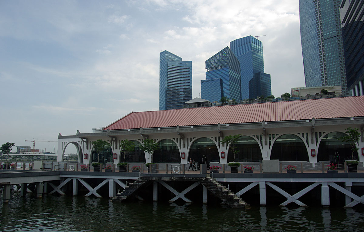
This is a tight two-anchor run and both anchors are non-food. The useful logic is historical as much as scenic. Clifford Pier was built in 1933 as a sea-arrival landing point and became widely known in Chinese as Red Lamp Pier because red oil lamps once guided seafarers in.[1] Cavenagh Bridge was manufactured in Scotland in 1868, assembled in 1869, and still stands as Singapore's oldest bridge in its original form and its only suspension bridge.[2][8] Put those two together after office hours and the river stops behaving like generic waterfront real estate. It turns back into an arrival system.
The key timing note in this article is an inference from route geometry, official district context, and current community-review patterns, not a formal city rule: the cleanest weekday window is roughly 19:00 to 20:15.[3][4][5][6][7] That is late enough for the towers and bridge lamps to start working, early enough that the denser Merlion-side photo traffic has not fully pushed back through the narrower river crossings, and short enough to keep the whole sequence inside a 35 to 50 minute envelope.
Place-specific texture matters here because this strip of Singapore carries more than one city at once. Clifford Pier belongs to the era when the harbor received immigrants and passengers by sea; the bridge belongs to the era when Empress Place and Commercial Square needed a fixed link strong enough for movement but modest enough that even its warning signs still speak in an older traffic vocabulary.[1][2][8] Expat Living's river-walk piece helps on the modern layer: begin from Raffles Place MRT Exit G, head along Bonham Street toward the Fullerton side, and let the river assemble itself in sequence rather than arriving from the showpiece side already overloaded with expectation.[5]
Anchor 1: Clifford Pier - start with the harbor, not the skyline
Clifford Pier should be the first room because it opens outward before it folds inward. The building's arches and waterfront edge still feel like a threshold, which is exactly what they were designed to be.[1] If you come in from Raffles Place, the approach is brief and clean: office towers at your back, the old waterfront in front, the city suddenly running on a much older clock.[5]
Do not rush to convert this into a checklist stop. Give the pier 10 to 15 minutes on first contact. Look at the curve of the facade, the relation between the colonnade and the water, and the way the open harbor air still cuts through one of the most managed districts in Singapore. Current Google Maps review streams repeatedly value Clifford Pier less as a destination to "complete" than as a calm edge to pause on, photograph lightly, and use as a reset before moving back toward the river proper.[6]
This is also where one Singapore-specific fact changes the mood of the walk. "Red Lamp Pier" is not nostalgic branding added later. It is the memory of an actual working harbor cue, and once that name is in your head the building stops reading like a hotel-adjacent facade and starts reading like transport infrastructure with afterlife.[1]
Anchor 2: Cavenagh Bridge - let the second room narrow the city
From Clifford Pier, turn back toward the river and let Cavenagh Bridge be the closing room. The bridge is useful because it compresses everything the first anchor leaves open. Its historic signs, suspension structure, and pedestrian scale keep the river from dissolving into pure panorama.[2][8]
The bridge's own story helps the walk feel more exact. It linked government offices in Empress Place to Commercial Square, and after Anderson Bridge opened in 1910 to ease the traffic load, Cavenagh settled into lighter use.[2] Time Out's bridge survey is useful here because it states the point cleanly: this is the oldest bridge in Singapore still standing in original form, the city's only suspension bridge, and the vintage notices banning vehicles, cattle, and horses are still part of the experience.[8]
That changes how you should use it. Do not treat Cavenagh as a shortcut to somewhere else. Treat it as the final editing tool of the route. Stop at the entrance signage, walk to the middle span, then look back west and south rather than forward only. Current community-review patterns suggest the bridge works best as a short stay rather than a lingering photo camp, especially once more people start bunching at the centerline for skyline shots.[7]
8 local moves that materially improve the walk
First, start from Raffles Place MRT Exit G, not from Bayfront or the Merlion side. The route improves when the old waterfront appears after the financial district rather than after the tourist cluster.[5]
Second, make Clifford Pier the first anchor and keep first contact short, around 10 to 15 minutes. It is a threshold room, not a place to stall.[1][6]
Third, aim for the weekday 19:00-20:15 window. This timing is an inference from current review patterns and the way light and crowd load shift across the district.[3][4][5][6][7]
Fourth, let the water stay open in front of you at Clifford before turning inland again. The harbor-facing pause is what gives the route its first exhale.[1][6]
Fifth, double back toward the river for Cavenagh instead of crossing the first bridge you see. The sequence works because the first anchor opens and the second anchor compresses.[2][5][8]
Sixth, read the bridge hardware and warning signs before you read the skyline. On Cavenagh, the infrastructure tells you more than the postcard angle does.[2][8]
Seventh, keep the whole sequence to 35-50 minutes unless you are deliberately expanding into the longer 2.5km Singapore River walk, which Expat Living estimates at about 50 minutes before longer scenic pauses.[5]
Eighth, budget this as a SGD0 move and add dinner only after the walk has done its job. The point is to reset the city, not to turn the route into a reservation funnel.[3][5]
Non-local trapline: 3 common mistakes and cleaner alternatives
Mistake 1: starting from the Merlion side because it is the search-result default
Better move: begin from Raffles Place Exit G and let Clifford Pier arrive as an old harbor threshold, not as overflow from a landmark queue.[1][5][6]
Mistake 2: crossing Cavenagh immediately as if it were only a connector
Better move: hold the bridge for the end. Its value is in how it narrows the river and sharpens the relation between the civic and commercial banks.[2][8]
Mistake 3: arriving after 21:00 and expecting blue-hour calm
Better move: work inside the 19:00-20:15 window on a weekday. That recommendation is an inference from present community patterns, not an official rule, but it keeps the route in its most legible state.[5][6][7]
Concrete go details
- Start point: Raffles Place MRT Exit G, then Bonham Street toward the Fullerton side.[5]
- Anchor order: Clifford Pier first, Cavenagh Bridge second.[1][2][5]
- Best weekday window: about 19:00-20:15 based on route geometry plus current community patterns.[3][4][5][6][7]
- First-anchor dwell time: about 10-15 minutes at Clifford Pier before turning back toward the river.[1][6]
- Whole route time: about 35-50 minutes for the tight two-anchor version; 2.5km / 50 minutes if expanded into the longer river walk.[5]
- Spend: SGD0 unless you add a later stop by choice.
- Queue/reservation reality: no tickets, no reservations, only periodic photo bottlenecks on the bridge and heavier landmark traffic closer to the bay-side icons.[6][7]
- Historical anchors: Clifford Pier 1933; Cavenagh Bridge 1868-1869; Anderson Bridge 1910 as the traffic-relief successor.[1][2]
- Navigation cue: if you find yourself pulled toward the Merlion before touching Clifford Pier, you have drifted too far east too early.
Portable takeaway artifact: the Singapore river reset card
| Condition | Start | Pace | Decision rule | Why it works |
|---|---|---|---|---|
| Weekday, architecture and air first | Clifford Pier | Short first pause, slower bridge finish | Reach Clifford close to 19:00 and finish Cavenagh before 20:15 | Harbor threshold first, river compression second.[1][2][6][7] |
| Humid evening, low-effort city reset | Raffles Place Exit G | Keep the walk tight | Skip extensions until the two-anchor sequence is complete | The route is strongest when it stays compact and contrast-driven.[5][6][7] |
Singapore has bigger waterfront spectacles. This one earns its place by staying small. One harbor threshold, one suspension bridge, and a short walk between them are enough to turn an evening back into a city.
Sources
- Roots.sg, "Transforming Clifford Pier Building and Customs House: The Fullerton Heritage" (1933 construction, sea-arrival landing point, "Red Lamp Pier" context, preserved harbor-threshold architecture).
- Roots.sg Collection, "Cavenagh Bridge spanning the busy Singapore River" (manufactured in 1868, assembled in 1869, linked Empress Place and Commercial Square, traffic eased after Anderson Bridge in 1910).
- Visit Singapore, "Singapore River | Guide to Attractions, Hotels & Restaurants" (official district framing for the riverfront walk and surrounding precinct).
- Visit Singapore, "Civic District Singapore | Art, Culture & Walking Tours" (official north-bank context for the civic side of the route).
- Expat Living, "A Singapore River Walk - Historical Buildings, Statues and Bridges" (Raffles Place Exit G start, 2.5km river-walk frame, 50-minute estimate, Cavenagh sequencing).
- Google Maps community listing, Clifford Pier, Singapore (recent review stream on atmosphere, pause value, and photo behavior; accessed 2026-04-02).
- Google Maps community listing, Cavenagh Bridge, Singapore (recent review stream on nighttime views, pedestrian flow, and center-span photo bunching; accessed 2026-04-02).
- Time Out Singapore, "7 Bridges Along The Singapore River And The Stories Behind Them" (Cavenagh as Singapore's oldest bridge in original form, only suspension bridge, surviving pedestrian-only notices).
- Wikimedia Commons, "File:Singapore - Clifford Pier 0001.jpg" (documentary photograph used for the cover image).