Many first visits to Santiago waste Cerro San Cristóbal by treating it as a summit selfie with a transport problem attached. The cleaner local read is narrower and more sequential. Start at Baquedano, walk up Pío Nono, take the historic funicular, spend a short pause at Cumbre, then descend east by cable car toward Pedro de Valdivia. Chile Travel's current hill itinerary effectively recommends that shape, while the operator's own pages make the mechanics explicit: Baquedano is the nearest metro for the Pío Nono side, Pedro de Valdivia is the nearest for the Oasis side, and the two mechanized systems connect at the summit within walking distance of each other.[1][2]
The numbers keep the route honest. The current operator FAQ says Teleférico Santiago runs Tuesday to Sunday from 10:00 a.m. to 7:45 p.m., tickets start at CLP 2,000, the Pedro de Valdivia line takes about 12 to 15 minutes round-trip between Oasis and Cumbre, and children under 12 need an adult with them.[1] Chile Travel's 2026 itinerary adds the vertical logic: the main Pío Nono approach begins near Baquedano, the walk-only alternative to the top takes about 60 to 90 minutes, and the historic funicular does that climb in about 10 minutes before the cable car carries you down the opposite side.[2] The official park map sharpens the geometry further: Baquedano sits about 800 metres from the hill access, the summit reaches 880 m above sea level, and the internal route distances make clear that the hill is not a decorative lump beside downtown but a large public terrain with several workable exits.[3]
That heritage layer matters. Emol's April 2025 centenary piece notes that the funicular opened on 25 April 1925, was declared a Historic Monument in 2000, still covers the 500 metres between Pío Nono and Cumbre every day, and now takes roughly 7 to 10 minutes to complete the ride.[4] Then came the other half of the contemporary hill. After the new Pío Nono cable-car line opened in March 2026, Cerro San Cristóbal gained even more mechanized access from the Bellavista side.[1][5] Yet for a first serious read of the place, the older order still works better: climb with the hill's memory, descend with the city's eastward panorama.
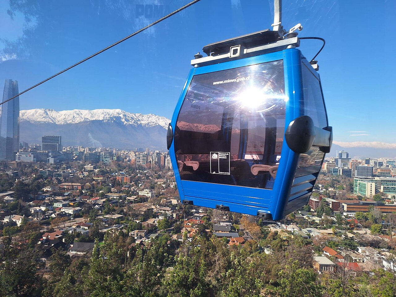
Image context: the cover uses a real 2024 Wikimedia Commons cable-car photograph rather than a skyline crop or map. That is the right recognition cue because this article depends on motion through the hill, not on the summit as a static postcard.[10]
Start at Pío Nono so the hill rises through the old city first
Pío Nono is the right entrance because it lets the hill begin inside ordinary Santiago street life instead of above it. Chile Travel's route starts at Baquedano Station for exactly that reason: you leave the Metro, walk a short Bellavista seam, and the ascent begins before the city has fully detached from your body.[2] The park map supports the same read with its 800-metre Baquedano approach marker and its placement of the funicular at the southern urban edge of the hill.[3]
The funicular itself is not just convenient transport. It is a piece of civic inheritance still doing daily work. Emol's centenary coverage describes it as part of the collective memory of Santiago and notes the recent accessibility upgrades at both Pío Nono and Cumbre.[4] That changes the feel of the climb. You are not taking a generic viewpoint shuttle. You are entering the park through a line that generations of families have already used to convert street-level Santiago into public altitude.[4]
Recent community advice still converges on the same sequence when time is limited. In a February 2026 r/Santiago thread about a short layover, the most concrete local-style answer recommends going up by funicular and coming down by cable car, precisely because it keeps the hill from collapsing into a dead-end outing.[8] That advice is worth keeping because it matches the hill's actual structure instead of fighting it.
Read Cumbre as a transfer terrace, not a dead-end photo deck
The summit is where many visitors flatten the experience. They arrive, photograph the Virgin, stare at the skyline, then return the way they came. The better move is to treat Cumbre as a hinge. Chile Travel's itinerary is explicit that the cable car can take you from Cumbre down to Oasis on the Pedro de Valdivia side, where the park begins to release you toward a different Santiago altogether.[2]
That is why the eastward descent matters. The operator site says the cable-car lines connect across the summit and that the Pedro de Valdivia side lies 15 to 17 minutes on foot from its Metro station once you leave the park.[1] Seen from above, the city reorganizes itself on the way down: Bellavista and the older central grain fall behind, Providencia and the tower-heavy east side widen out, and the hill stops looking like a hilltop attraction and starts reading as a hinge between urban systems.[1][2][3]
Community-review surfaces are useful here for a narrower reason than "what should I do?" Google Maps, Tripadvisor, and recent local threads are not the authority on the hill's meaning, but they are a live check on the friction layer: whether people are reporting heavy waits, whether access confusion is clustering around one station, and whether the day is actually delivering the view you came for.[6][7][8][9] That is a very Santiago habit to borrow: use official pages for the route, then use community surfaces to confirm the day has not gone sideways.
8 local moves that make this portrait land
- Enter from Baquedano and save Pedro de Valdivia for the exit. The route works because the hill first rises out of Bellavista and only later opens toward the east-side city.[1][2][3]
- Let the funicular handle the first climb on a short visit. The walking route is real and worthwhile, but the official timing difference between 60 to 90 minutes on foot and about 10 minutes by funicular changes what kind of outing you are building.[2][4]
- Buy ahead if timing matters. The operator allows online booking and says the grace window for a reservation is only 10 minutes.[1]
- Do not linger too long at the lower station. The point of Pío Nono is transition. Once you are there, board and let the hill start doing its work.
- Use Cumbre as a short terrace, then keep moving. The summit is strongest as a hinge between systems, not as the only place where the route has to mean something.[1][2]
- Descend by cable car to Oasis rather than reversing by funicular. That is the move that turns a view into an urban reading.[1][2][8]
- If accessibility matters, use the mechanized route deliberately. The operator notes elevator access at Zoo Station and Oasis Station, and Emol notes the recent universal-access improvements at Pío Nono and Cumbre.[1][4]
- Check same-day friction before you leave. The official hours page sets the rule set; Google Maps, Tripadvisor, and local threads tell you whether the day feels smooth, crowded, hazy, or confused.[1][6][7][8][9]
Non-local trapline: 4 mistakes and the better alternative
Mistake 1: treating Cerro San Cristóbal as a summit only
Better alternative: read it as a through-route. The hill gets clearer when the climb and descent land in different neighborhoods.[1][2][3]
Mistake 2: hiking the whole main path on a short city window because it sounds more "authentic"
Better alternative: use the funicular for the first visit. The authentic part is not the calorie count. It is the way the route lets the city reassemble in sequence.[2][4]
Mistake 3: returning to Pío Nono immediately after the summit pause
Better alternative: keep the descent eastward. The cable car is what lets the hill finish its urban sentence.[1][2][8]
Mistake 4: arriving too late for a multi-system ride
Better alternative: budget enough daylight and operating time for two mechanized segments plus the summit transfer. With 10:00 a.m.-7:45 p.m. hours and walking still built into the route, this is a place to approach with margin rather than with airport energy.[1]
Concrete go details
- Best window: a clear weekday or Sunday with at least 90 minutes left before the 7:45 p.m. closing time, so the Pío Nono climb, summit pause, and Oasis descent can happen without compression.[1][2]
- Expected spend: current operator pricing starts at CLP 2,000, with higher totals depending on the combination of systems and the day you travel.[1]
- Queue and reservation reality: timed bookings have only a 10-minute grace window; if you are improvising, use same-day review surfaces before you head over.[1][6][7][9]
- Where to pause: once at Cumbre for the hinge-view, then again as the cable car opens the east-side city on the descent.
- Navigation cue:
Baquedano -> Pío Nono walk -> Funicular up -> short Cumbre pause -> Cable Car down to Oasis -> Pedro de Valdivia side exit.[1][2][3] - Numeric anchors worth keeping: 800 metres, 500 metres, 7-10 minutes, 10 minutes, 12-15 minutes, 15-17 minutes, 60-90 minutes, 880 m, 10:00-19:45, 25 April 1925, March 2026.[1][2][3][4][5]
Santiago has bigger museums, better lunch neighborhoods, and more obvious skyline viewpoints than this one hill. What it has less often is a single public place that explains so much city structure so quickly. Enter from the old side, leave from the east side, and Cerro San Cristóbal stops being a hill with a photo at the top. It becomes a clean vertical reading of Santiago itself.
Sources
- Teleférico Santiago, official site and FAQ: current hours, station addresses, ticket floor, summit connection, ride durations, reservation grace period, wheelchair access, and Pedro de Valdivia / Baquedano approach times.
- Chile Travel, "What to do on Santiago's Cerro San Cristóbal?" (updated 2026-01-14; official itinerary describing the Baquedano start, the 60-90 minute walking alternative, the 10-minute funicular ride, and the cable-car descent to Oasis).
- Parquemet, "MapaParque" PDF: official hill map with the Baquedano approach distance, summit altitude, and internal route geometry.
- Emol, "Funicular de Santiago cumple 100 años" (2025-04-25; centenary report covering the 1925 opening, Historic Monument status, 500-metre route, current 7-10 minute ride time, and accessibility works).
- Emol, "Inauguran Teleférico II Pío Nono-Plaza México" (2026-02-28; local report on the new Bellavista-side cable-car access that broadened the hill's mechanized network before the March 2026 opening).
- Google Maps search, "Funicular de Santiago" - current place-status and community-review surface for same-day friction checks.
- Google Maps search, "Teleférico Santiago Oasis" - current place-status and community-review surface for the east-side descent station.
- Reddit
r/Santiago, "Only a few hours in Santiago" (2026-02-26; recent community advice recommending the funicular-up, cable-car-down sequence for a short city window). - Tripadvisor, "Cerro San Cristobal" (current community review surface for route reality, access confusion, and visitor timing checks).
- Wikimedia Commons, "File:TELEFÉRICO, CERRO SAN CRISTOBAL, SANTIAGO DE CHILE.jpg" (documentary cover photograph source page).