Rotterdam is easy to overread from above ground. First-time walks drift toward the Erasmus Bridge, the skyline, the Wilhelminapier, and the clean postcard drama of water plus towers. The sharper local move is lower and stranger. Start at the Maastunnel's north-side pedestrian and cycle entrance near Parkkade, descend, cross under the Nieuwe Maas, and let the tunnel explain the city before the skyline does.[1][5]
The Maastunnel is not a hidden attraction. It is a working connector with a remarkable public surface. Rotterdam's own river-crossing page frames the essentials: the tunnel opened in 1942, was built with the immersed-tube method, runs about a kilometre under the river, and separates traffic into four tubes: two for cars, one for cyclists, and one for pedestrians.[1] The same municipal page gives the everyday scale: more than 45,000 motor vehicles, about 6,000 cyclists and moped riders, and roughly 150 pedestrians use it daily.[1] That imbalance is exactly why the pedestrian version feels so good. You get a quiet civic machine mostly to yourself while a much larger city keeps moving nearby.
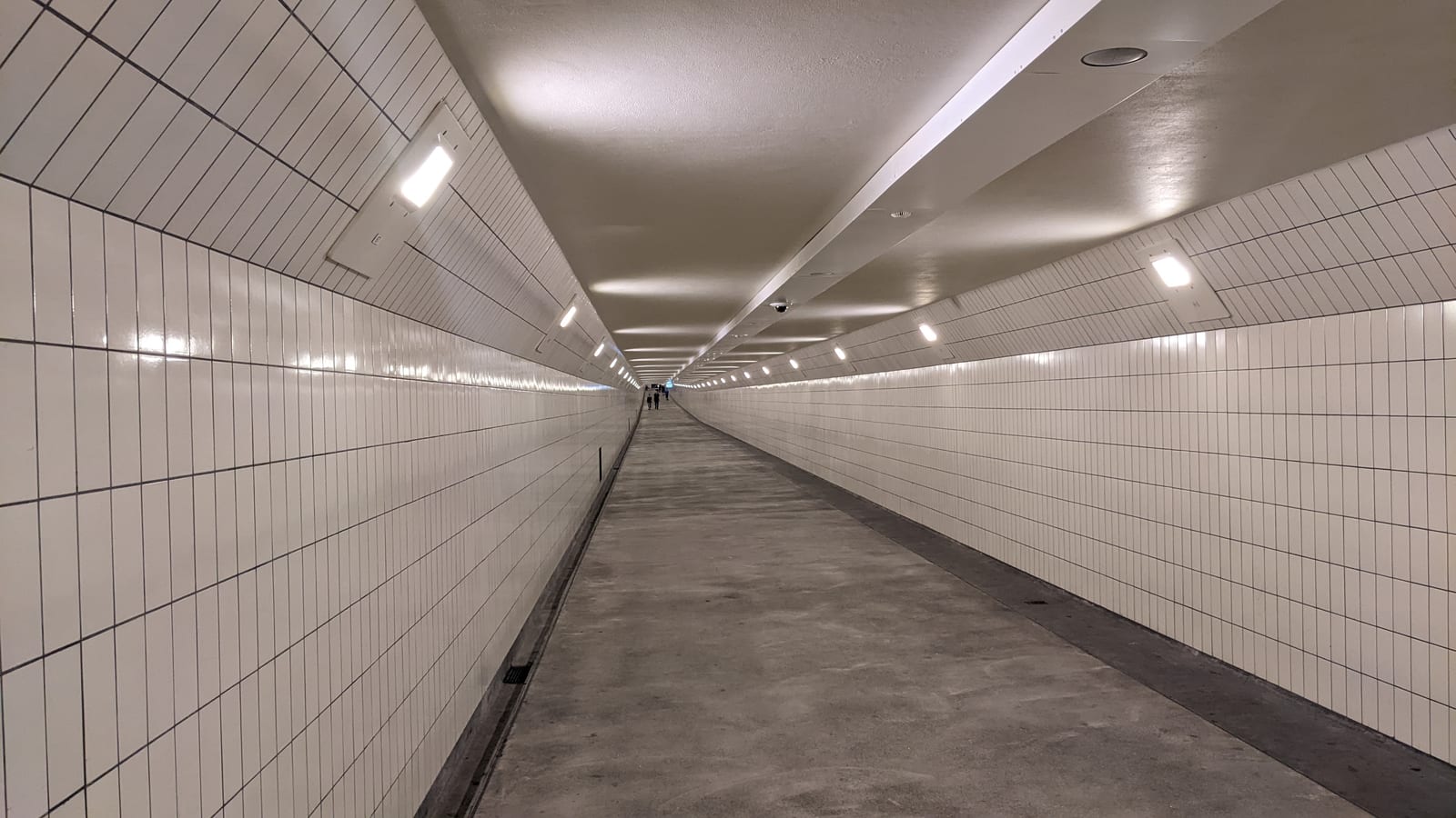
The image matters here because the tunnel is the point, not a generic Rotterdam view. The cover uses a real Wikimedia Commons photograph of the restored pedestrian passage, taken in 2022, after the long renovation returned the tube to public use with cleaner lighting and surfaces.[8] It shows why this route works: the experience is not "go see a tunnel." It is a controlled under-river walk where the city becomes legible through grade, tile, sound, rule, and exit.
Why this object changes the city
Rotterdam's geography is blunt: the Nieuwe Maas is not decorative water but a working cut through the city. Bridges make that fact visible from a distance. The Maastunnel makes it physical. You enter through a small above-ground building, lose the sky, drop by escalator or lift, and then walk or ride through a separated tube built for a city that had to keep north and south attached without stopping ships.[1][4]
That design history is unusually specific. The municipality notes that bridge plans were debated in the 1930s, but the tunnel was chosen after cost and shipping-clearance problems made a high bridge less attractive.[1] The construction used nine prefabricated concrete sections, each about 61 metres long, sunk into a dredged trench before the internal walls were opened and the tunnel completed.[1] The Dutch Cycling Embassy's 2025 Rotterdam self-guided tour adds the mobility layer: the original car-focused concept was adjusted so cyclists and pedestrians received their own dedicated tubes, and today's cycle access still depends on escalators designed for bicycles, with lifts available on both sides.[4]
That is the local texture visitors miss. The tunnel does not only connect two banks. It preserves an older Rotterdam argument about who gets a river crossing. The car tubes carry the volume, but the human tubes carry the memory: cyclists descending into the river approach, pedestrians moving one level below, and the tiled tunnel turning infrastructure into a public room.[1][4]
9 local moves that make it land
- Start on the north side at Parkkade. The entrance at Parkkade 30 is the cleaner first read because you arrive from the museum-park and river-edge side instead of treating the tunnel as an accidental shortcut.[5]
- Choose your mode before you descend. If you are walking, use the pedestrian tube. If you are cycling, commit to the cycle tube. The municipality separates the rules by mode for a reason.[1]
- Do not walk your bike in the cycle tunnel. Rotterdam's posted rules say walking beside a bicycle is not allowed in the bike tube; pedestrians and people walking beside a bike belong in the pedestrian tunnel.[1]
- Use the lift for awkward loads. The rules direct visitors with prams, scooters, bicycles with child seats, trailers, or mobility aids to the lift rather than the escalator.[1]
- If you ride down with a bicycle, manage the handlebars. The Dutch Cycling Embassy notes that the escalator is designed for bicycle movement and recommends turning the handlebar 90 degrees to prevent rolling.[4]
- Read the escalator halls, not just the tunnel tube. The municipal history calls out Jaap Gidding's mosaics above the long escalators, with ships, cars, bicycles, mermaids, fish, and waves marking the shift between upper city and underworld.[1]
- Use the green-light escalator and keep moving. Current house rules explicitly say to use an escalator with a green light, not sit on the escalators, and avoid blocking them with sport or stunt behavior.[1]
- Check maintenance if the lift matters to you. The city says the Maastunnel has scheduled maintenance through end-2026, including lift-maintenance evenings when escalators may still run but lift access changes.[2]
- Surface on the south side before deciding the return. The value is in completing the crossing. If you immediately reverse underground, you miss how different the river feels once the tunnel has put you in Rotterdam-Zuid.[1][4]
Non-local trapline
Mistake 1: choosing the Erasmus Bridge because it is the famous crossing. The better alternative is to use the bridge when you want skyline drama and the Maastunnel when you want Rotterdam's river mechanics. The tunnel is the more exact lesson in separated modes, working water, and north-south dependency.[1][4]
Mistake 2: treating the wooden escalator feel as a novelty photo stop. The better alternative is to treat the descent as part of the transport grammar. Local review surfaces keep returning to the old escalators because they are the transition device: street, hall, escalator, tube, other bank.[5][7]
Mistake 3: assuming "tunnel" means simple access. The better alternative is to check the live maintenance page before a mobility-dependent visit. The ventilation and escalator buildings began restoration work from late November 2025, and the city warns that halls can sometimes be partly sectioned while access is kept open as much as possible.[2][3] A recent cycling account of the renovation workaround is a useful reminder that this crossing keeps operating through practical substitutions, not tourist convenience theater.[6]
Mistake 4: mixing pedestrian and cycle behavior. The better alternative is to respect the tube split. The bike tunnel allows cyclists and certain electric mopeds, has a 30 km/h maximum speed, and forbids walking beside the bike; the pedestrian tunnel is where walkers, skaters, scooters, and people walking beside bikes belong.[1]
Concrete go details
- Best window: late morning or early evening outside the strongest commuter push. The tunnel is working infrastructure, not a timed attraction, so the aim is calmer flow rather than a reservation slot.[1][5]
- Expected spend: EUR0 for the crossing itself.[5]
- Queue reality: no booking or ticket queue; the friction is escalator, lift, and maintenance flow. If the lift is essential, check the city maintenance page before leaving.[2]
- Navigation cue:
Parkkade 30 north entrance -> escalator or lift -> pedestrian tube or cycle tube -> south-side exit -> surface, look back at the ventilation/escalator building -> decide whether to return underground or continue south.[1][5] - Etiquette: no smoking or vaping, no alcohol or drugs, no sitting on escalators, no pets on escalators, and no professional filming without permission from the city.[1]
- Numeric anchors worth keeping: 1942, four tubes, nine immersed sections, about 61 metres per section, about 20 metres below N.A.P. at the deepest part, 45,000 daily motor vehicles, 6,000 daily cyclists and moped riders, 150 daily pedestrians, 30 km/h in the cycle tube, and maintenance through end-2026.[1][2]
The Maastunnel is not Rotterdam's prettiest river crossing. That is why it is useful. It strips the city down to movement: who gets a tube, who waits for a bridge, who rides, who walks, who surfaces where. Use it once and the skyline stops floating. The river becomes a system you have actually crossed.
Sources
- Gemeente Rotterdam, "Oeververbindingen" (official Maastunnel history, construction method, tube layout, daily-use counts, renovation notes, and house rules for pedestrian, cycle, and escalator use).
- Gemeente Rotterdam, "Afsluitingen Maastunnel" (official current maintenance and closure page, including end-2026 maintenance framing and lift-maintenance notices).
- Gemeente Rotterdam, "Maastunnelgebouwen" (official restoration Q&A for the ventilation and escalator buildings, starting late November 2025, with access and heritage-color details).
- Dutch Cycling Embassy, Rotterdam Self-Guided Tour 2025 (PDF guide explaining Maastunnel's cycling role, bicycle escalator design, separated cyclist/pedestrian tubes, and post-2020 safety improvements).
- Verken Rotterdam, "Maastunnel Noord Fiets- & Voetgangersingang" (local listing for the Parkkade entrance, free 24/7 access, recent-renovation framing, and visitor review themes around the wooden escalators).
- BikePush, "Inside the Tunnel Where You're Forced To Ride A Bike" (published September 5, 2025; recent cycling-focused account of the Maastunnel's pedestrian-closure workaround and temporary bike-share logic during renovation).
- Google Maps, "Maastunnel Noord Fiets- & Voetgangersingang" (live local review and navigation surface for checking the entrance pin, visitor photos, and current access signals).
- Wikimedia Commons, "File:Voetgangerstunnel (Maastunnel), Rotterdam (2022) 08.jpg" (documentary photographic source page for the lead image by Donald Trung Quoc Don, taken July 16, 2022).