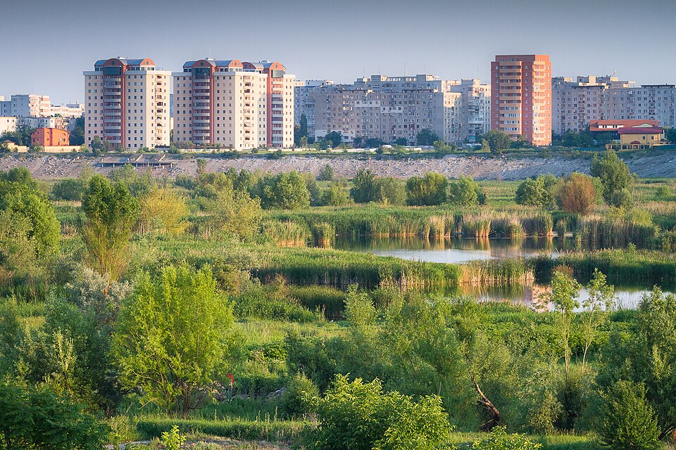
Bucharest has many easier parks. Văcărești is not one of them, and that is the point. It sits only about 5 km from the centre, covers roughly 183 hectares, and is officially framed by its park association as Romania's first urban natural park and the capital's largest compact green space.[1] The right visit is not a casual bench-and-fountain loop. Enter by the Asmita Gardens side or Săvinești, walk the dike and signed paths slowly, and let the wetland feel half accidental and half protected.[2][5]
The local nickname, "Delta Văcărești," can mislead visitors into expecting a polished nature attraction. What makes the place memorable is rougher. The official history places it in the Dâmbovița floodplain, then describes the late-communist hydro-technical project that began in 1988, the expropriations and failed lake works, the abandonment after 1989, and the spontaneous rewilding that followed.[3] By 2016, that failed infrastructure had become a government-recognized natural park.[1][3] You are walking inside an urban afterlife: concrete rim, reeds, water, willows, birds, apartment blocks, and a city that did not quite know what it had until the non-plan became habitat.
That is why Văcărești works best as a place portrait, not a checklist stop. The park's own biodiversity page is careful: it says the site does not contain old "natural habitats" in a pristine sense; it is made of recently established communities, including wetland vegetation, willow, poplar, shrubs, and a recorded floristic inventory of 331 species and subspecies.[6] A good visitor respects that ambiguity. This is not untouched wilderness. It is a city basin that turned into a living system and then had to be protected from the habits of a city.
How to Read the Room
Use the edge before you drop into the interior. From the Asmita Gardens corner, the rim gives the park its first useful sentence: reeds and water below, towers close enough to make the wetland look improbable, traffic still audible but no longer in charge. From Săvinești, the mood is more local and less landmarked. The official regulation lists these access points, plus the Splaiul Unirii and Șoseaua Vitan-Bârzești intersection, as arranged places to enter over the concrete dike edge; it also says public access through unarranged places is not allowed.[2]
This is the first non-local trap. Visitors see gaps, desire lines, and rough edges, then assume the park is informal enough to improvise. The better alternative is to treat the looseness as ecological, not procedural. Use the arranged entries, stay on designated paths, and do not turn the interior into a shortcut. The regulation says pedestrian movement and recreational jogging belong on designated, marked paths, and it restricts bicycle traffic to the signed main route between Asmita Gardens and Săvinești plus the outer dike rim.[2]
Once inside, slow down. A local family guide in Romanian describes the visit as a "mini-excursion" rather than a classic playground park: good shoes, water, patience, flexible routing, stops for observation, and a willingness to adapt after rain because some paths can turn muddy or periodically wet.[5] That is the second trap: arriving dressed for a city promenade. The better alternative is to arrive as if you were doing a short field walk inside town. Wear shoes that can take dust or mud, carry water, and avoid building the day around cafe infrastructure inside the park. There is not much of it.
9 Local Moves
- Go early, especially for birds. A recent birding thread from a visitor who toured on March 17 drew local advice to try the 6-7 a.m. window because birds retreat when more people are present.[8]
- Use Asmita if you want the most legible first view. The tower-and-wetland contrast is immediate, and the access point is one of the official arranged entries.[2]
- Use Săvinești if you want the visit to feel less like an attraction. It is also an official access point and makes the park read more as neighborhood edge than city highlight.[2]
- Keep the route short on a first pass. Pacer lists a 3.2-mile route with about 7,500 estimated steps and no meaningful elevation gain; that is enough if you stop often instead of marching through.[7]
- Carry binoculars only if you will actually pause. Local guide and community sources push birdwatching here, but the payoff comes from waiting at reed and water edges, not from trying to cover every path.[4][8]
- Do not feed wildlife. The official rules prohibit feeding wild species, with narrow winter exceptions handled by the park administration.[2]
- Keep dogs on leash. Pets are allowed only under control, with leash rules and cleanup obligations; loose dogs are exactly the kind of visitor behavior that breaks a wetland visit for birds and people.[2]
- Treat drones as a permission issue, not a toy. The regulation bars low-altitude flight over the park under 100 meters without prior consent, which matters because the basin looks tempting from above.[2]
- Leave before dusk if you do not know the exits. Local and guide sources frame the park around daylight use, and the practical value of Văcărești is observation, not night wandering through reeds and rough paths.[4][5]
The Visitor Mistakes to Avoid
Mistake 1: expecting a manicured park. The better alternative is to want a protected wetland with city noise around it. Local guide sources repeatedly frame Văcărești as a dawn-to-dusk, prepare-your-own-water, rough-path nature visit rather than a landscaped leisure park.[4][5] That divided expectation is useful: if you need lawns, benches, cafes, and predictable paving, choose another Bucharest park. If you want to see how nature reoccupied a failed infrastructure basin, Văcărești is the stronger move.
Mistake 2: chasing the word "delta" too literally. The better alternative is to read layers: floodplain, reservoir ambition, abandonment, reed beds, conservation. The park association's history and biodiversity pages make the story more exact than the nickname. The place matters because it is a recent, urban, semi-wild ecosystem with protected-area management, not because it copies the Danube Delta in miniature.[3][6]
Mistake 3: trying to make the loop too athletic. The better alternative is to choose two or three observation pauses and turn back before fatigue makes the rougher ground annoying. Luderio's family-oriented local guide recommends flexible routing, a base segment, and 2-3 stopping points rather than a rigid march.[5] That advice is not only for families; it is the correct rhythm for anyone who wants the wetland to reveal itself.
Mistake 4: ignoring the rules because the place feels informal. The better alternative is to see the rules as the reason the informality can survive. No off-trail wandering, no fires, no fishing or swimming, no wildlife disturbance, no dumping waste, no motorized vehicles or electric scooters except authorized uses, and no commercial activity without consent: these boundaries are what keep the "found" quality from becoming neglect.[2]
Concrete Go Details
Best window: spring and autumn are the richest seasons for variety, with early morning the best birding gamble; in summer, go early or late because the exposed dike and wetland heat make midday a poor trade.[4][5][8]
Expected spend: RON0 for ordinary access. Budget instead for transit, water, and maybe a coffee before or after, not inside the park.[4][5]
Queue or reservation reality: no timed ticket. The friction is weather, shoes, entry choice, and whether paths are muddy after rain.[5]
Navigation cue: Timpuri Noi metro approach or a direct ride to the Asmita Gardens / Splaiul Unirii side -> official access over the dike -> rim view -> short interior path or dike segment -> return by the same known access point.[2][4][5]
Etiquette: stay on paths, take waste back out, keep dogs leashed, do not feed animals, do not pick a route through reeds for a photo, and do not treat the basin as a drone backdrop unless you have permission.[2]
Numeric anchors worth keeping: 183 hectares, about 5 km from the centre, hydro works beginning in 1988, abandonment after 1989, protected natural park status in 2016, 331 recorded flora species and subspecies, a 3.2-mile walking route, roughly 7,500 steps, and a birding window around 6-7 a.m. when quiet matters most.[1][3][6][7][8]
The reward is not spectacle. It is calibration. After Văcărești, Bucharest's green map stops being only parks, boulevards, and palace-scale axes. You start noticing the city's unfinished edges, its leftover water logic, and the places where residents, scientists, volunteers, and administrators had to decide whether a messy green accident was worth defending. Here, it was.
Sources
- Asociația Parcul Natural București, "The Park" (official overview of Văcărești Natural Park's protected-area status, 183-hectare scale, 5 km centre distance, and urban-natural-park role).
- Administrația Parcul Natural Văcărești, "Park regulations" (official access points, trail rules, bicycle limits, wildlife, dogs, drones, waste, swimming, fires, and visitor conduct).
- Asociația Parcul Natural București, "Brief history" (official history of the floodplain, 1988 hydro-technical works, post-1989 abandonment, rewilding, and 2016 natural-park recognition).
- Salut București, "Văcărești Nature Park (Delta Văcărești)" (local English guide to hours, free access, metro approach, duration, seasonality, mosquito reality, and wetland character).
- Luderio, "Parcul Natural Văcărești (Delta Văcărești) - București" (Romanian local family guide, updated within the last year, with access notes, prepared-walk advice, mud/rain caveats, and flexible route structure).
- Asociația Parcul Natural București, "Specii și habitate" (official biodiversity page describing wetland vegetation communities, dominant trees and shrubs, and the 331-species flora inventory).
- Pacer, "Văcărești Natural Park in București | Walking Map" (walking-route page showing a 3.2-mile, roughly 7,500-step route and a recent 2026 review timestamp).
- Reddit r/VisitingBucharest, "Birding at 'Văcărești' Natural Park" (recent community thread with March 17 birding report and local timing advice for early-morning bird activity).
- Wikimedia Commons, "File:Lacul Vacaresti.jpg" (documentary photographic source page for the lead image by Mihai Petre / Stratoreaper, taken June 4, 2012).