Pittsburgh has many bigger itineraries than this, but not many that explain the city so quickly. The useful move is compact and mechanical at first: start at the Duquesne Incline lower station on West Carson Street, ride the car up to 1220 Grandview Avenue, then turn west and keep walking a few minutes to the Point of View statue.[1][2][4][5] One anchor gives you the city's old vertical transport logic in working form; the second gives you the clean hilltop pause where the rivers, bridges, and downtown mass finally settle into one legible picture.[1][4][5]
That sequence works because Pittsburgh is not really a flat skyline city. It is a city of edges, slopes, and abrupt reveals. The Duquesne Incline is useful not only because it is historic, but because it still stages that reveal properly. The official site notes that the line has been part of Pittsburgh's transportation system since 1877, that it was rescued and restored by local residents in 1963, and that it still uses the original wooden cable cars.[1] Visit Pittsburgh's incline guide adds the practical rhythm: the inclines run approximately every 5 minutes, and the Duquesne round trip is $5.00 for adults.[2][3]
The hilltop turn matters just as much. Visit Pittsburgh's Mount Washington page says that Grandview Avenue runs the length of the mount and that one of the things to do there is catch your breath and a photo at the Point of View statue.[4] Discover the Burgh makes the route more precise in local terms: the statue is only a few minutes farther west after you exit the Duquesne Incline, and that extra walk strips away some of the platform churn without giving up the city-facing frame.[5] The pairing matters because the incline gives you ascent and recognition, while the short westward walk gives you air.
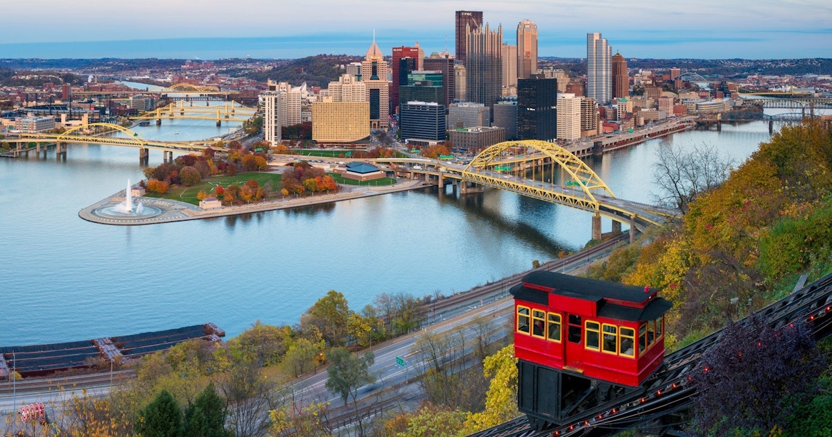
Image context: the cover uses a real Visit Pittsburgh photograph tied to Mount Washington and the Duquesne climb. For this route, the right image is one that keeps both hillside and skyline in the same frame rather than isolating the towers by themselves.[3][4]
Why this Pittsburgh pairing lands better than treating the incline as the whole outing
The first advantage is compression. The Duquesne lower station parking address is 1197 W. Carson St., the upper station is 1220 Grandview Ave., and the local guide's Point of View stop is only a few minutes farther west on foot.[1][2][5] That means you can get one of Pittsburgh's most famous city reads without turning the thing into a half-day project. It stays urban, repeatable, and easy to slot into a late afternoon.
The second advantage is that the walk corrects the platform. If you only ride up, take the standard picture, and ride down, the city can stay flattened into a known image: fountain, bridges, towers, done. Grandview's westward stretch slows that reflex down. You keep the skyline, but you also feel the hilltop length of the neighborhood, the way Grandview is really a long ledge rather than one official overlook.[4][5]
The third advantage is behavioral. The official site is unusually frank about operational reality: there are no reservations, weekend afternoons are busiest, and on Saturday and Sunday after noon you should expect roughly a 10-minute wait in both directions.[1] That already tells you how locals and visitors collide there. Google Maps keeps the present tense alive on both anchors, showing that these are not dead heritage markers but still-used places with current review traffic and ongoing place status.[6][7] The better move, then, is not to fight the busiest moment at the exact platform edge. It is to use the incline for what it does best, then shift your lingering to the short walk west.
Use the incline as the opening move, not the whole story
The Duquesne Incline should do the first piece of work for you. The official schedule is simple: open 365 days a year, from 6:30 a.m. to 12:30 a.m., with no reservation layer to think about.[1][2] The payment layer is equally old-school. The official site says to bring exact cash and not to assume debit or credit card acceptance, while also noting that Port Authority or PRT-style transit payment remains part of the system; Visit Pittsburgh phrases the same point in visitor terms by saying Duquesne is exact-cash only while ConnectCards still work.[1][2][3] The local move is to arrive with the payment question solved before you are in line.
At the top, resist the urge to treat the observation deck as the finish. Turn west. The Mount Washington neighborhood page frames Grandview Avenue itself as the long scenic asset, and the Point of View stop gives that long ledge one especially clean punctuation mark.[4] Discover the Burgh's description is the useful one here: a few minutes farther west, one clearer pause, one wider breath in the view.[5] The route gets better exactly when you stop trying to maximize attractions per hour and instead let one climb and one short walk do the whole job.
The other small correction is accessibility and approach. The official site warns that there are many steps from the lower station parking lot, while the upper station and its observation deck are wheelchair accessible.[1][2] So the route has two valid versions. If you want the historic ascent, start below at Carson Street. If you care more about the hilltop read than the mechanical ride, begin from Grandview Avenue and keep the westward walk as the anchor.
8 local moves that make this Mount Washington close-up read correctly
First, go late afternoon into blue hour, not full dark from the start. The skyline is stronger when the rivers and bridge lines are still readable before the lights take over.[3][4][8]
Second, do not aim for Saturday or Sunday after noon unless you are willing to queue. The official site already tells you that is the busiest window and that waits of about 10 minutes in both directions are normal.[1]
Third, bring exact cash or a working transit card. The mistake is assuming casual tap-to-pay at the window. This is still a very literal system.[1][2][3]
Fourth, if stairs are an issue, start from the upper station instead of the lower parking lot. The lower approach includes many steps; the top station is the accessible one.[1][2]
Fifth, ride up, then walk west before you settle into photos. The article's whole point is that the cleanest city read comes after the first platform instinct has worn off.[4][5]
Sixth, use the Point of View stop as the real pause. The incline gives you arrival energy; the westward pause gives you composition and breathing room.[4][5]
Seventh, treat Grandview as a ledge, not a single overlook box. The neighborhood page is explicit that the avenue runs the length of the mount, and the view changes as you shift along it.[4]
Eighth, keep the outing tight. One ride, one westward walk, one pause. Pittsburgh rewards clean geometry more than overpacking.[1][4][5]
Non-local trapline: 4 common mistakes and the better move
Mistake 1: treating the Duquesne Incline observation deck as the entire visit
Better alternative: ride up, orient yourself, then keep walking west to the Point of View stop so the skyline opens beyond the most crowded platform edge.[4][5]
Mistake 2: showing up on a weekend afternoon and acting surprised by the line
Better alternative: use weekday late afternoon if you can. The official site already flags Saturday and Sunday after noon as the busiest stretch, with about 10 minutes of waiting in each direction.[1]
Mistake 3: assuming modern payment norms
Better alternative: bring exact cash or a compatible transit card and do not count on ordinary card processing at the window.[1][2][3]
Mistake 4: starting at the lower lot when mobility is the real constraint
Better alternative: begin at 1220 Grandview Ave. and use the accessible upper station and hilltop walk instead of fighting the steps from below.[1][2]
Concrete go details
- Best window: weekday late afternoon into blue hour, after the workday turn but before full darkness flattens the rivers and bridges.[3][4][8]
- Expected spend: $2.50 each way or $5.00 round trip for adults on the Duquesne Incline.[2][3]
- Queue and reservation reality: no reservations; weekends after noon are busiest, with about 10 minutes of line time in both directions.[1]
- Where to stand or sit: use the upper station and deck for the first read, then make the real stop a few minutes west at Point of View.[4][5]
- Navigation cue:
1197 W. Carson St. -> Duquesne Incline -> 1220 Grandview Ave. -> turn west -> Point of View. - Numeric anchors worth keeping: 1877, 1963, 6:30 a.m., 12:30 a.m., 5 minutes, $2.50, $5.00, 10 minutes, 1197, 1220.[1][2][3]
Pittsburgh can get reduced too easily to one famous photo. This route fixes that without becoming complicated. The incline reminds you that the skyline sits above a real grade and an old transport problem; the westward Point of View walk reminds you that the city only becomes fully readable when you let the hilltop length itself enter the frame.
Sources
- Official site of the Duquesne Incline (current hours, no-reservation policy, exact-cash and transit-card guidance, weekend wait note, lower-station steps, upper-station accessibility, and 1877/1963 history).
- Duquesne Incline, "Hours and Fares" (adult and child pricing, round-trip fares, and upper-station accessibility details).
- Visit Pittsburgh, "Guide to Riding the Inclines in Pittsburgh" (approximate five-minute cadence, round-trip pricing, parking-lot orientation, and Grandview/Shiloh context).
- Visit Pittsburgh, "Mount Washington" neighborhood page (Grandview Avenue as the long overlook spine and the Point of View statue as a designated stop).
- Discover the Burgh, "Mount Washington Neighborhood Guide" (local guide, updated March 9, 2026, describing Point of View as a few minutes west of the Duquesne Incline and framing the neighborhood's hilltop texture).
- Google Maps search, "Duquesne Incline Pittsburgh" (current place-status and community-review surface).
- Google Maps search, "Point of View Pittsburgh" (current place-status and community-review surface).
- r/pittsburgh thread, "Which incline is better for a date?" (recent local discussion pointing visitors toward the Duquesne view and a Grandview walk around sunset).