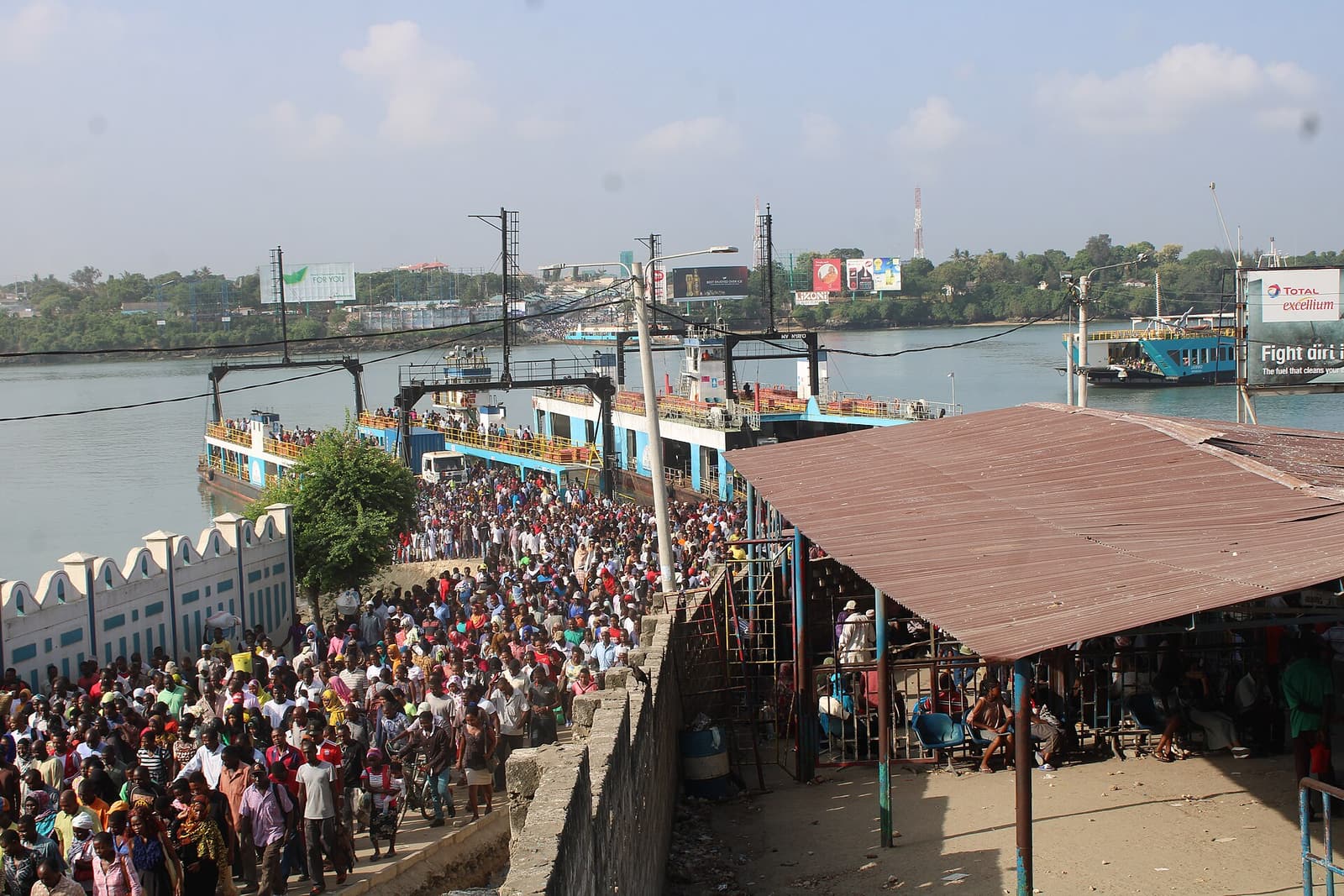
The boat ride is the smallest part of crossing at Likoni. The water is only about 500 metres wide and the sailing usually takes 5–10 minutes. What demands attention is the handoff: pedestrian bay to moving ramp, ramp to a mixed people-and-vehicle deck, then a second ramp that releases everyone into a mainland transport stage now being reorganized [2][4].
Likoni's street microcosm is therefore a gradient, not an itinerary. It carries Mombasa Island's southbound street across Kilindini Harbour and sets it down in Likoni, where the same flow separates toward local neighborhoods, Ukunda, Diani and the wider South Coast. Make the crossing because the journey continues south; do not manufacture a round trip merely to occupy a commuter deck.
Keep the visit to two thresholds: the island-side pedestrian bay near Likoni Mall, then the mainland transport area around the Total petrol-station landmark. The ferry itself costs a pedestrian KSh 0 and requires no reservation [5]. From central Mombasa, allow 45–75 minutes to reach the mainland exit, longer if ramps, weather or port traffic slow the cycle. For a first crossing, use roughly 09:30–15:30 on a weekday as an avoidance window rather than a promise of quiet. A July 2026 local guide identifies 06:00–09:00 and 16:30–20:00 as the commuter peaks [2]. If the holding area is already too dense for you to choose where to stand, or staff have stopped the flow, wait outside or leave; do not convert delay into pressure on the gate [2][6].
Seventy metres change the whole crossing
The public plan in November 2025 was to separate flows more cleanly: Parliament recorded a short-term strategy of deploying the larger MV Jambo and MV Safari for pedestrians, smaller vessels for vehicles, police for crowd control, and a modern pedestrian holding bay on the Likoni side [1]. Live maintenance has narrowed that design. Ramp repairs begun on April 21, 2026 cover 70 metres of damaged infrastructure in two phases, and KPA told NTV that the work would temporarily leave only two ferries able to dock for mixed pedestrian and vehicle loading. Barriers and rerouted approaches are now part of the crossing, with work intended to continue during off-peak hours and at night [3].
Likoni still operates through the night, but “24 hours” does not mean a fixed passenger frequency. Ferries rotate according to demand and operating conditions; the ride can be much shorter than the wait [2]. In 2026, the usable width and position of the ramps matter as much as the vessel count. That is the article's boundary: no promised departure time and no promised wait.
So the first local move happens before the terminal: ask for “Ferry” when boarding in town and confirm the matatu is going to the island-side Likoni terminal. Digo Road and Posta are usual CBD starting points; the drop is near Likoni Mall and Nyerere Road [2]. Carry a loose KSh 50 note or smaller change. The current local range from the CBD is about KSh 30–50, with rain, traffic and the evening rush capable of moving the price [2].
The second move is preparation, not speed. Put the phone away and make the bag easy to open before security. Bags may be checked, and the local guide explicitly warns against photography around the terminal, gates, screening area and boarding points [2]. The cover photograph in this article comes from an openly published documentary archive; it is not permission to reproduce that camera position during a present-day crossing [9].
Past security, the waiting bay is where an outsider's instincts usually become counterproductive. The closed gate appears to reward proximity, so newcomers press forward. The better third move is to stand slightly back or use a concrete bench, keeping the bag zipped and in front. When the gate releases the first dense wave, let it lengthen. Local guidance notes that a person who follows just behind the initial surge will often board the same vessel with less pushing [2]. If the wave reverses or security closes the route, stop and leave space; a gate closure cancels the move rather than inviting an improvised one [6].
The operative question is not how quickly you can reach the hull. It is whether a stable pedestrian line still exists from bay to side walkway.
A street with a tidal gradient
When boarding begins, the fourth move is simple: follow the marked pedestrian side, never the central vehicle lane, and do not stop on the ramp. Ferries here carry people and road traffic on the same broad deck. The arrangement turns the vessel into a movable piece of street, but only if its lanes remain distinct [2].
The ramp also changes underfoot. At lower tide its angle can become steeper; in rain the concrete and metal can become slippery. That makes the fifth move a physical one: keep one hand free, take smaller steps when the incline sharpens, and let a rolling suitcase trail under control rather than drag you downhill [2]. Anyone traveling with heavy luggage, small children, an older relative or limited mobility should avoid the peak waves and treat private road transport via the Dongo Kundu bypass as a legitimate alternative, not a failure to have the “authentic” experience [2].
Once aboard, move out of the landing flow. The sixth move is to stay in the pedestrian area along either side, clear of the vehicle lanes and hot machinery. A rail can give air and a view of Kilindini Harbour, but a photograph is not worth obstructing the deck or ignoring staff directions. On July 25, 2026, NTV reported that services were temporarily halted after a confrontation over alleged vehicle prioritization escalated and security intervened [6]. That was an exceptional incident, not a normal portrait of the crossing. It establishes a clear abort rule nevertheless: if crowd movement becomes confrontational or officials halt service, move away from the interface and make another plan.
Likoni has carried this urban seam for almost nine decades. A Kenyan Court of Appeal judgment records that ferry service began in 1937, first with pontoons driven by motorboats; modern ferries arrived in 1957. The judgment's real concern was jurisdiction, and it emphasized that the channel is the gateway to the Port of Mombasa rather than an ordinary inland crossing [8]. That history explains the scene better than nostalgia does. The ferry did not become part of local life because it was picturesque. It became local life because the port, island and southern mainland required a continuous link.
It also explains why the passenger's clock sometimes yields. Likoni is both commuter route and navigable harbor. The ferry must fit inside a system larger than its own 500-metre line. Waiting is not always evidence that nobody has designed the crossing; sometimes it is the visible negotiation among ship traffic, tide, ramps, ferries, vehicles and a very large pedestrian wave.
The mainland exit is still moving
The ferry's bow becomes an exit before many first-timers have decided what comes next. Resist the urge to solve that problem on the ramp. The seventh move is to keep walking through the mainland gate, then stop outside the main discharge line. If the journey continues toward Ukunda or Diani Junction, the July local guide uses the Total petrol station as the clearest onward landmark and quotes roughly KSh 80–120 for the matatu; nearby Likoni stops are generally KSh 30–50 [2]. Large luggage occupying a seat may add about KSh 50–100, so agree on that before departure [2].
Treat those amounts as a planning range, not a tariff. A through journey from the Mombasa CBD to Ukunda or Diani Junction therefore begins around KSh 110–170 without an extra luggage seat, while the ferry portion remains free. The eighth move is the one that protects that range: say the destination, ask the fare, and confirm any bag charge before the matatu leaves.
Do not memorize a bay number. The mainland transport edge is being reorganized. On July 8, 2026, a dispute over a temporary informal stage brought operators, county enforcement officers, traders and motorists into a confrontation. Local reporting tied the tension to a KSh 400 million decongestion and upgrade project that is changing pedestrian space and the room available to matatus, tuk-tuks and boda bodas [4]. The ninth move is therefore to use Total as a recognition cue, then verify the current stage with a conductor or uniformed official on the day. A pin can preserve a landmark; it cannot preserve a traffic arrangement.
The current Google-review stream, aggregated by Wanderlog, is useful mainly as a boundary check. Reviewers consistently register a free pedestrian crossing, a short trip and much longer waits in busy periods, but the same page also repeats conflicting fleet and fare details [7]. Treat community reviews as evidence of felt conditions, not as an operating notice. Likoni is legible when you know the sequence, but it is not frictionless; dated local reporting and instructions on the ground outrank a reviewer's remembered number.
Four ways to misread 500 metres
The first mistake is treating an off-peak recommendation as a service guarantee. The 09:30–15:30 window avoids a known commuter crest; it cannot cancel current ramp work, a port movement or a security stop. Arrive in daylight with enough margin to abandon the crossing if the holding area is unstable [2][3][6].
The second is fighting for the front of the closed gate. There is no prize for being the first foot on a five-minute sailing. Stand back, let the opening wave stretch, then move continuously along the pedestrian side [2].
The third is using the archival rush-hour image as a camera instruction. Pedestrians do cross for free after the May 2026 vehicle-tariff changes [5], but photography around screening, gates and boarding is discouraged. Do not try to recreate the elevated 2020 view, reverse into commuters for a selfie, or occupy the rail while people are moving [2][9].
The fourth is boarding the first vehicle that calls a familiar South Coast name. The mainland stage is under pressure and its informal geometry can change [4]. Clear the ramp, orient to the Total landmark, confirm the destination and price, and only then board [2].
The Likoni Ferry reveals Mombasa without pretending to summarize it. A tidal ramp gives the street a changing slope. Repairs narrow the interface. Cars, handcarts and pedestrians share a hull without sharing a lane. Five or ten minutes later, the second ramp meets a transport stage whose positions are being argued over in real time. The boat joins the two shores; the ramps explain how the city is actually holding them together.
Sources
- National Assembly of Kenya, Hansard Report — Wednesday, 12 November 2025 — official account of short-term ferry deployment, terminal crowd control, ramp expansion and the planned pedestrian holding bay.
- Exploring Mombasa, “A Pedestrian's Guide to the Likoni Ferry” (July 10, 2026) — local step-by-step account of entrances, security, peak windows, boarding flow, tides, fares and mainland connections.
- NTV Kenya, “Why the Likoni ferry service will be disrupted for six months” (August 3, 2026) — current reporting on the 70-metre, two-phase ramp repair and temporary docking limits.
- 001 FM, “Tensions Flare at Likoni Ferry Terminus Over Disputed Transport Stage” (July 9, 2026) — Mombasa-area reporting on the mainland stage dispute and the current decongestion works.
- Kenyans.co.ke, “KPA Raises Prices for Small Cars to Ksh180, Loaded Trucks Ksh7,900 at Likoni Ferry” (May 23, 2026) — confirmation that the revised vehicle tariffs did not end free pedestrian passage.
- NTV Kenya, “Chaos erupts at Likoni ferry as passengers clash with security officers” (July 25, 2026) — report on a temporary service halt that defines the article's crowd-safety abort condition.
- Wanderlog, “Likoni Ferry — Mombasa” — current Google-review aggregation used as community evidence for perceived crowding and wait variability, not as an authority for changing fleet or fare details.
- Kenya Law, Mombasa County Government v Kenya Ferry Services & another [2018] KECA 21 — Court of Appeal history of the 1937 service, early pontoons, modern ferries and the channel's national-port role.
- Wikimedia Commons, “Morning rush hour at the Likoni Ferry in Mombasa” — source page for Tumo Maokisa's February 7, 2020 documentary photograph, original dimensions and CC BY-SA 4.0 license.