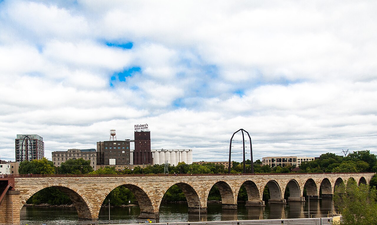
Minneapolis is easy to misread from a car window. The cleanest correction is short: start with the Stone Arch Bridge, then let Mill Ruins Park slow the walk down on the west bank. The bridge is not just a place to take a skyline picture. It is a former railroad crossing turned pedestrian and bicycle room, and it gives the city a way to explain itself through water power, flour, stone, repair, and evening foot traffic.[1][4]
The practical update matters. Old advice about partial access is now stale: the Minneapolis Park and Recreation Board announced that the Stone Arch Bridge fully reopened on July 21, 2025, after MnDOT finished the repair project ahead of schedule.[3] MnDOT's project page puts the work in its proper scale: the bridge repair ran from April 2024 through July 2025, cost $38.5 million, and focused on stone repair, mortar replacement, and other preservation work.[2] That means the 2026 move is not to detour around a closure. It is to use the reopened bridge deliberately.
Do it in one compact loop. Arrive on the west bank near Mill Ruins Park or Water Works, check the wind and crowd level, then cross the Stone Arch Bridge slowly enough to use the middle of the span as a pause rather than a checkpoint. MPRB lists the bridge at 100 Portland Ave. with park hours from 6 am to midnight, and identifies the bridge as the link among Father Hennepin Bluff Park, Mill Ruins Park, and West River Parkway.[1] That is the shape of the outing: one crossing, one ruin field, one river edge.
The local timing is late light, not peak noon. A recent Twin Cities thread about Mill Ruins and the Stone Arch Bridge turns on a simple piece of local advice: golden hour is the magic window, especially when the view opens westward across the bridge.[7] That matches the site better than a midday checklist. The stone reads warmer, the falls flatten into sound and mist, and the downtown towers stop behaving like a backdrop. Plan a 60-75 minute visit if you want the bridge plus the west-bank ruins. Give it 90 minutes if you add interpretive stops, a bench pause, or the east-bank bluff.
The first local move is to enter from the Mill District side if you have only one pass. It lets the skyline, the falls, and the old industrial shell arrive in sequence rather than all at once. The second is to keep to the right on the bridge and let bikes pass cleanly; this is a working pedestrian and bicycle corridor, not a boardwalk photo studio.[1][5] The third is to stop in the widened view zones, not in the middle of the moving lane. The fourth is to turn around once while crossing so you see the mill district as a machine, not as a set of buildings behind you.
Mill Ruins Park is the reason the route should not end when the bridge ends. The park board describes the area as a historic site with walking and biking paths through the former milling district, and places it beside Water Works and directly under or near the bridge.[4] The specific Minneapolis texture is this: the city became powerful because St. Anthony Falls could turn wheat into industrial volume. The ruins are not decorative rubble. They are the visible remains of a river economy that made "Flour Milling Capital of the World" more than civic branding.[6]
That is why the second half should be slower than the first. After the bridge, drop into Mill Ruins Park rather than racing straight toward the museum doors or a restaurant reservation. Read the exposed walls, canals, and interpretive signs as a floor plan. The National Park Service frames the Stone Arch Bridge as a key link in the St. Anthony Falls Heritage Trail, a roughly two-mile self-guided system with pedestrian walkways, bicycle lanes, signs, and kiosks.[5] The Minnesota Historical Society gives a similar visitor-scale version of the same idea: a 1.8-mile loop crosses the river on the Stone Arch Bridge and Father Louis Hennepin Bridge.[6] You do not need the whole loop to get the point, but you should understand that the bridge belongs to a system.
The fifth local move is to make Mill Ruins the "sit" section. Use a bench or low wall after the crossing and let the bridge recede into the background. The sixth is to keep the route free unless you have intentionally chosen a museum stop: the walk itself costs $0. A recent local visitor-advice thread pairs the Guthrie's free river views, the Stone Arch Bridge, and Mill City Museum in one suggestion, which is useful precisely because it shows how quickly this block can expand if you let every nearby attraction attach itself to the walk.[8] A realistic spend range for the route itself is therefore $0-$0; budget separately for parking, transit, food, or ticketed interiors.
The seventh move is to choose your direction by weather. On a hot bright day, cross first, then use Mill Ruins Park and the Water Works area as the decompression zone. In cold wind, do the reverse: start with the west-bank ruins while you still have patience, then let the bridge become the exposed finale. The eighth is to avoid overloading the outing with "nearby" stops. The Guthrie, Mill City Museum, Main Street, and the river locks can all make sense, but not if they turn this 75-minute urban room into a four-hour obligation.[6][7][8]
There are three common visitor mistakes. The first is treating the bridge as a single photo point. The better alternative is to cross it as a piece of city infrastructure, noticing the commuting rhythm, bike flow, falls view, and west-bank landing together.[1][5] The second is using repair-era advice without checking the reopening. The better alternative is to rely on the July 21, 2025 reopening notice and MnDOT project page before assuming any closure pattern.[2][3] The third is skipping Mill Ruins Park because the bridge view felt like "enough." The better alternative is to spend at least 20-30 minutes on the west bank, where the milling story becomes physical rather than scenic.[4][6]
The go details stay simple. Best window: the last 75 minutes before sunset, with a weather backup in the early morning. Time needed: 60-90 minutes. Spend: $0 on foot, with a small parking budget if you drive. Queue reality: no reservation, but expect the bridge to compress around sunset, warm weekends, and event nights. Navigation cue: aim for 100 Portland Ave., cross the bridge, then return through Mill Ruins Park and Water Works rather than doubling back immediately.[1][4]
Minneapolis riverfront advice often gets too broad: see the museum, walk the bridge, find dinner, add the falls, maybe rent a bike. This route is narrower and better for it. Let the Stone Arch Bridge do the crossing. Let Mill Ruins Park do the explanation. In one short loop, the city stops being a skyline beside water and becomes what it has always been here: a place where the river was made to work, and then made public again.[4][5][6]
Sources
- Minneapolis Park and Recreation Board, "Stone Arch Bridge" - official address, park hours, access links, and site overview.
- Minnesota Department of Transportation, "Stone Arch Bridge in Minneapolis Project" - official repair scope, schedule, benefits, and $38.5 million project cost.
- Minneapolis Park and Recreation Board, "Stone Arch Bridge fully reopens to public ahead of schedule," July 21, 2025 - recent reopening confirmation.
- Minneapolis Park and Recreation Board, "Mill Ruins Park" - official park page on walking/biking paths, Water Works, and the historic milling district.
- National Park Service, "Stone Arch Bridge" - Mississippi National River and Recreation Area page on the bridge as a St. Anthony Falls Heritage Trail link.
- Minnesota Historical Society, "Area Attractions" - Mill City Museum visitor page describing the St. Anthony Falls Heritage Trail loop and nearby riverfront sites.
- Reddit / r/TwinCities, "Mill Ruins/Stone Arch bridge. What time of day is best?" - local/community timing discussion with recent golden-hour advice.
- Reddit / r/Minneapolis, "Visiting tips" - recent local/community advice thread that places the Stone Arch Bridge within a Mill District visitor sequence.
- Wikimedia Commons, "File:Stone Arch Bridge in Minneapolis -a.jpg" - photographic image source used for the article image.