Mexico City’s historic center gets worse the moment you treat it like an obligation march. The better move is to keep one tight civic seam and let the city explain itself block by block.
The highest-yield version is short: Palacio de Bellas Artes and its metro/alameda edge, then the first stretch of Madero until Casa de los Azulejos. That is enough to understand how Centro Histórico layers transit pressure, monumental architecture, and dense pedestrian flow without turning the walk into a blur.
This guide keeps a strict two-anchor scope:
- Bellas Artes / Metro Bellas Artes for entry timing, orientation, and crowd control.
- Madero’s early pedestrian seam ending at Casa de los Azulejos for pace, stop order, and exit discipline.
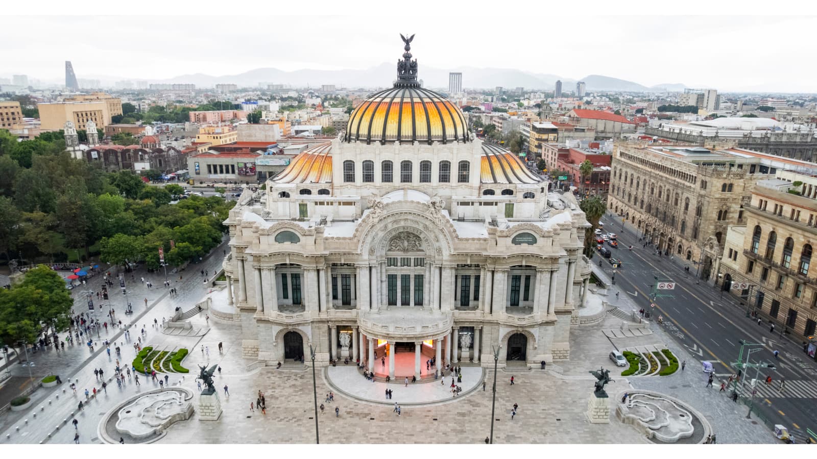
Image note: the hero image shows Bellas Artes itself, the exact visual landmark that keeps this route legible when the surrounding foot traffic gets dense.
A local texture detail matters here. Mexico City’s own walking-route page for Alameda Central – Av. Madero strings together 10 points in one compact corridor: Alameda Central, Hemiciclo a Juárez, Corpus Christi, Bellas Artes, Torre Latinoamericana, the San Francisco atrium and temple, Casa de los Azulejos, Palacio de Iturbide, La Profesa, and Joyería La Esmeralda.[1] That density is why a narrow route beats a maximalist one.
Anchor 1: Bellas Artes works best as your control point, not your grand finale
The first useful number is underground, not architectural. Mexico City’s own Bellas Artes metro page says the station serves at least 50,000 passengers daily, connects Lines 2 and 8, and has four entrances, with the western Paris-style entrance remaining the most recognizable one for visitors.[3]
That one fact changes how you should approach the district. Bellas Artes is not just a building you admire from the plaza; it is the safest reset button in a zone that can otherwise feel overfull within minutes.
Metro logic matters before you even reach the surface. The city’s own metro guide gives three practical cost anchors: a paper ticket costs 5 pesos, the rechargeable mobility card costs 10 pesos, and service normally runs 5:00–24:00 Monday–Friday, 6:00–24:00 Saturday, and 7:00–24:00 Sunday and holidays.[4] It also flags weekday peaks at roughly 7:30–9:30 and 17:30–20:00.[4]
That means the easiest operating windows for this route are usually late morning or early evening shoulder periods, not the exact middle of commuter crush.
The cultural anchor is still worth respecting. Mexico City’s Bellas Artes venue page describes it as the country’s largest artistic venue, the seat of INBAL, with capacity for about 1,700 people, an exterior construction start in 1904, and the familiar art nouveau / art deco split that makes the building read clearly even on a fast pass.[2] Google Maps’ current place listing is still useful as a same-day status check if you want the route to include an interior museum stop rather than only a surface walk.[5]
Anchor 2: the first stretch of Madero is where the old center turns readable
Once you leave Bellas Artes, the goal is not to “do Madero.” The goal is to let one pedestrian corridor compress the district into a manageable rhythm.
Francisco I. Madero Avenue is short enough on paper to look trivial. In practice, it is dense enough that first-timers often lose route discipline within the first few blocks.
The reason this short segment works so well is that it already contains multiple decision points without demanding a full-centro commitment. The official walking route places Torre Latinoamericana, the Atrio y Templo de San Francisco, and Casa de los Azulejos in sequence after Bellas Artes.[1] That gives you built-in checkpoints, which is exactly what an overloaded historic center needs.
Casa de los Azulejos is the right stopping edge for this micro-run. Google Maps describes it as an 18th-century palace with the blue-and-white tiled facade still doing the visual work, and the current place listing still treats it as an active late-closing stop.[6] In other words, it stays available later than Bellas Artes and gives the corridor a natural endpoint instead of an endless eastward drift.
Madero’s broader historical logic matters too. Chilango’s local history rundown treats the street as more than a shopping corridor: it is one of the city’s oldest traced streets, long known as Plateros, later renamed for Francisco I. Madero, and memorable precisely because its direct line to the Plaza Mayor made it a ceremonial route for repeated triumphal entries.[7] The same local piece notes that the corridor only became pedestrian-first in 2009, before turning fully pedestrian in 2010, which helps explain why heritage facades, crowd flow, and storefront pressure all now stack into one compressed street room.[7] On the ground, that is exactly how the corridor feels: less like a road and more like a moving public interior. A recent local video guide to Bellas Artes also reinforces the practical point here: visitors still use the palace and its edges as the cleanest orientation anchor before committing deeper to Centro traffic, which supports keeping this first run short and legible.[8]
Pick the route by energy, not ambition
This corridor gets better when you match it to your attention span instead of forcing a grand historic-center sweep.
- 45-minute version: start at Bellas Artes, do the plaza and metro-orientation reset, enter Madero, and stop once the San Francisco zone has clarified the street’s rhythm. This is the right version if you mainly want to decode the district rather than accumulate stops.[1][3]
- 90-minute version: this is the default article route—Bellas Artes, one steady Madero push, then a clean finish at Casa de los Azulejos with one pause along the way.[1][6]
- 2-hour version: do Bellas Artes interiors first if the current listing still shows it open that day, then run the same street seam after you exit. Because Casa de los Azulejos usually stays available later, the route keeps a natural late stop even after a museum-first start.[5][6]
That choice matters because the district punishes vague ambition. A short route with a clear stop edge is usually more memorable than a longer walk that dissolves into generic centro fatigue.
Two quick route pivots that save the walk
If the district is not giving you the default 90-minute version, switch fast instead of grinding through a bad hour.
- Museum-first pivot: if Bellas Artes is still open and you care about interiors, go inside first while the current listing still shows a same-day opening window, then use the Madero walk as the lighter second act because Casa de los Azulejos stays available later.[5][6]
- Crowd-first pivot: if metro flow already feels thick when you surface, keep the run brutally short—Bellas Artes orientation reset, one push through the San Francisco zone, then finish at Casa de los Azulejos without trying to earn extra centro points. The corridor gets better when you leave a little unfinished.[1][3][4][6]
That small willingness to pivot is what keeps the route feeling local rather than dutiful.
What to cut first when the route starts going bad
- Cut the interior stop before you cut the corridor. If Bellas Artes timing no longer works, keep the surface seam and drop the museum plan; the route still holds because the plaza-and-metro node remains the real control point.[2][3][5]
- Cut eastward ambition before you cut Casa de los Azulejos. The tiled house is the cleanest finish because it is visually unmistakable and usually open later than Bellas Artes.[1][6]
- Cut photo lingering before you cut the Bellas Artes reset. The slow plaza scan is what makes Madero readable; losing that orientation move costs more than losing a few minutes of extra stopping time.[2][3]
8 local moves that make this route work
First, start at Metro Bellas Artes, not mid-corridor. A dense central zone is easier when your first reference point is the most legible one.[3]
Second, avoid weekday peak bands if you can. The metro guide’s 7:30–9:30 and 17:30–20:00 warnings are not abstract; they are the difference between a reading walk and a shoulder-to-shoulder transfer zone.[4]
Third, if you need transit beyond one ride, buy the 10-peso mobility card instead of managing paper fare one trip at a time.[4]
Fourth, before entering Madero, do one slow visual sweep at Bellas Artes plaza level. The dome, the white-marble facade, and the western metro entrance together give you the strongest orientation cue on this route.[2][3]
Fifth, follow the official corridor order west to east: Bellas Artes, Torre Latino, San Francisco, then Casa de los Azulejos.[1] The sequence is better than improvising side turns too early.
Sixth, if the pedestrian stream starts feeling too compressed, use the San Francisco atrium zone as a breathing pocket rather than abandoning the route altogether.[1]
Seventh, treat Casa de los Azulejos as the clean first finish, not merely a midpoint. The route stays sharp when you stop there and only extend farther east if you still have energy.
Eighth, if Bellas Artes is closing soon and you care about interiors, reverse the order: go inside first, then do the Madero surface run while Casa de los Azulejos stays available later into the night.[5][6]
Non-local trapline: 3 common mistakes and better alternatives
Mistake 1: trying to “cover Centro Histórico” in one pass
Better alternative: run one short seam with two anchors only. The district gets more legible when you let density accumulate gradually.
Mistake 2: arriving through Bellas Artes at the exact commuter peak
Better alternative: use shoulder windows and keep metro entry friction low.[4]
Mistake 3: blowing past Bellas Artes and starting the walk only once you are already inside Madero’s crowd stream
Better alternative: use Bellas Artes as the planning node, then enter Madero with a fixed next stop already chosen.[1][3]
Time window, spend range, crowd reality, and one navigation cue
A clean Bellas Artes → Casa de los Azulejos run usually fits 90–150 minutes if you include one plaza pause, one steady Madero walk, and one short stop at the tiled-house end.
Expected minimum spend can stay very low:
- Metro paper ticket: 5 pesos[4]
- Rechargeable mobility card: 10 pesos before stored value reloads[4]
- Surface walk itself: free
Crowd reality:
- Bellas Artes station handles roughly 50,000 daily passengers.[3]
- The route’s official walking sequence already packs 10 points into the broader corridor.[1]
- Madero’s current form is pedestrian-first, so your friction is foot traffic rather than vehicle crossings.[7]
One navigation cue solves most first-timer drift: if you get turned around, reset with Bellas Artes behind you and Madero pulling east, then walk until the blue-and-white facade of Casa de los Azulejos tells you the first micro-run is complete.
Pocket route card
If you want the entire article compressed into one portable route card, use this version:
- Best first-pass window: late morning on weekdays, or any non-peak period outside the metro’s 7:30–9:30 and 17:30–20:00 crowd bands.[4]
- Start point: the Metro Bellas Artes side of the palace, ideally using the station/plaza area as your orientation reset.[3]
- Walking order: Bellas Artes → Torre Latino area → San Francisco atrium zone → Casa de los Azulejos.[1]
- Budget floor: 5 pesos if you use a paper metro ticket, 10 pesos before stored value if you buy the mobility card, and the rest of the route is free.[4]
- When to stop cleanly: if the corridor already feels dense by San Francisco, finish at Casa de los Azulejos and do not force a longer eastward drift.
- Reset cue: if you lose the line, put Bellas Artes behind you and let Madero pull you east until the tiled facade appears.
Sources
- MexicoCity.cdmx.gob.mx — Alameda Central – Av. Madero Walking Route (official stop sequence, 10-point corridor)
- MexicoCity.cdmx.gob.mx — Palacio de Bellas Artes venue page (INBAL seat, 1,700 capacity, 1904 start, architectural context)
- MexicoCity.cdmx.gob.mx — Metro Bellas Artes (Lines 2 and 8, four entrances, 50,000 daily passengers, west entrance cue)
- MexicoCity.cdmx.gob.mx — Using the Metro (ticket/card costs, service hours, weekday peak windows)
- Google Maps current listing — Palacio de Bellas Artes (current local listing surface, hours/status cue)
- Google Maps current listing — Casa de los Azulejos (current local listing surface, facade description, hours/status cue)
- Chilango — “21 curiosidades que no conocías de la calle Madero” (historic naming, ceremonial route, 2009/2010 pedestrianization context)
- Nomadas viajeros MX — Palacio de BELLAS ARTES CDMX | Qué ver, cómo llegar y TIPS (recent local/community confirmation of current visitor approach and access context)
- Source image used (Mexico City official tourism image asset)
- Wikimedia Commons — Casa de los Azulejos facade image source: file page