Luxembourg City is easy to flatten into an upper-town sequence of parapets, palace streets, and quick viewpoints. The cleaner first read is lower and stranger. Take the Pfaffenthal panoramic elevator down from the edge of Ville Haute, walk directly to the Vauban Towers, cross Béinchen once, and let the valley show you how this capital was actually held together before you climb back into the pretty overview.[1][2][3]
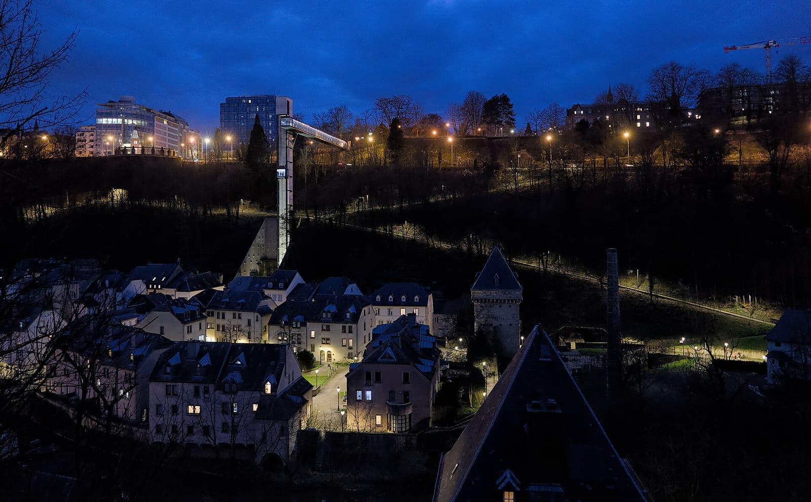
That move works because the elevator is not a novelty attached to the old town. It is the city's bluntest piece of self-explanation. Luxembourg City Tourist Office says the glass lift connects Parc Pescatore and the upper town to Pfaffenthal over 71 metres, runs every day from 05:45 until 01:00, is free of charge, and goes out of service on the first Monday of each month from 09:00 until 05:45 the following day for maintenance.[1] The Pfaffenthal district page makes the descent feel even more physical: the ride takes about half a minute, and the point is not only convenience but a spectacular read of the lower quarter and the wall line.[2]
Pfaffenthal itself gives the drop a reason. The official district guide describes it as one of the city's oldest areas, tied to the old Roman road through the Alzette valley and later to the Benedictine monks of Altmünster who worked the fertile ground there.[2] The official Vauban Circular Walk then sharpens the historical edge: when Vauban studied Luxembourg's weak points in 1685, Pfaffenthal and the surrounding heights demanded heavier fortification, which is why the valley still carries defensive towers, gate logic, and the narrow protective bridge called Béinchen between the Vauban Towers.[3]
Image context: the cover uses a real Wikimedia Commons photograph of the Pfaffenthal elevator at twilight. That is the correct recognition cue for this article because the route begins with a visible act of descent along the old wall, not with a generic skyline image.[9]
Why this lower-town seam explains more than staying on the balcony above
Luxembourg City certainly rewards the classic upper-town walk. The city itself still calls the Chemin de la Corniche "Europe's most beautiful balcony" and measures the promenade at 600 metres.[4] Recent local advice points visitors there quickly for good reason. In an April 2026 r/Luxembourg thread about whether the city is worth a weekend, one of the simplest suggested loops is Chemin de la Corniche -> old town -> Grund.[5] In another April 2026 thread answering a newcomer who knew nothing about the country, a local commenter says not to miss the Corniche at all because the town centre is compact enough that visitors can accidentally walk past the important edges; another commenter describes a sightseeing run that keeps going until the glass elevator itself becomes part of the loop.[6]
The useful correction is to treat those upper views as incomplete until you have tested the depth below them. Too many short visits stay on the terrace and keep the valley as scenery. The elevator destroys that distance in 30 seconds.[1][2] Once you arrive at Rue du Pont and walk onward, the fortifications stop behaving like backdrop. They regain thickness, gate function, and awkward geography. Google Maps' live place layer is genuinely useful here as a same-day check, because the route is so compact that a temporary closure or a crowd knot at the elevator matters more than an abstract "top sights" ranking.[8]
Why Béinchen is the real second anchor
The ride down is only half the point. Béinchen is what turns the descent into a place portrait instead of a transit trick. The official Vauban route describes the bridge as a protective wall spanning the river in narrow form between the two Vauban Towers; it once carried parapets and loopholes, and the three arches below could be shut with grates.[3] That description changes the walk. What looks at first like a quaint crossing is really a hard military seam left visible inside a modern capital.
The same official route adds two details that make Pfaffenthal feel less museum-like and more lived-in. First, the thin chimney on the riverbank is the remnant of a 1876 pumping station that once sent well water up to the Upper Town.[3] Second, the broader Vauban circuit around this area is 5.16 km and about 3 hours long, but this specific elevator-to-Béinchen slice only borrows one dense segment of it.[3] That is useful local discipline. You do not need to commit to the whole fortress walk to understand why this part matters.
There is also a practical Luxembourg texture in how lightly the city expects you to handle the move. The Pfaffenthal district page reminds visitors that all buses, trams, and trains within Luxembourg are free, which is why locals speak about reaching the old town and the lower quarters without ticket drama.[2] The recent Reddit thread for unexpected first-timers says much the same thing in plainer language: transport is free, reliable, and easy enough that the main risk is not logistics but missing the right urban edges.[6]
8 local moves that make this route land properly
- Start on the upper side on purpose. The elevator explains more when it functions as a deliberate descent from Ville Haute than when it serves as a random uphill shortcut later.[1][2]
- Check the first-Monday maintenance rule before you build the route around it. The elevator's current shutdown window starts at 09:00 on the first Monday of each month and runs until 05:45 the next day.[1]
- Ride facing the valley, not your phone. The whole point is to watch the wall line, bridge, and lower quarter snap into the same frame during the half-minute drop.[1][2]
- At the bottom, keep walking to the Vauban Towers before making any further decision. The route becomes legible only when the elevator's glass modernity meets the older gate-and-wall logic.[3]
- Cross Béinchen slowly once. Its narrowness is the message; if you rush through it as a connector, you miss why the bridge exists at all.[3]
- If you want an easier continuation, use the gentler
Hieloption instead of the long stair climb. The official Vauban route explicitly notes a no-step sloping alternative beyond the bridge.[3] - Treat the outing as a short fortress excerpt, not a checklist marathon. The beauty of this move is that it condenses the city into one vertical drop, one defensive bridge, and one lower-town seam.[3][5][6]
- Respect wet stone. The official Vauban route says no special equipment is required, but it does warn about slippery pavement, which is the one dull mistake that can ruin an otherwise elegant walk.[3]
Non-local trapline: 4 common mistakes and the better alternative
Mistake 1: using the elevator only as a photo gadget and going straight back up
Better alternative: walk through to the Vauban Towers and Béinchen. The descent means much more once it resolves into the defensive bridge and the lower-quarter geography.[2][3]
Mistake 2: doing the Corniche only and leaving the valley as background scenery
Better alternative: pair the balcony logic with one actual drop. Local advice keeps pointing people toward the Corniche, the old town, Grund, and the glass elevator as parts of the same city experience rather than sealed attractions.[4][5][6]
Mistake 3: arriving on the first Monday maintenance window with no backup
Better alternative: build around the published outage rule or come on another day. This route is too short to survive losing its key vertical move.[1]
Mistake 4: accidentally turning a short seam into the full Vauban circuit when time or shoes do not support it
Better alternative: keep the route disciplined unless you intentionally want the full 5.16 km / 3-hour fortress walk. The elevator-to-Béinchen section already delivers the core idea.[3]
Concrete go details
- Best window: late afternoon into early evening on a dry day. This is an editorial recommendation drawn from the elevator's long 05:45-01:00 span and local advice that Luxembourg's key old-town views reward a linked walk rather than a rushed midday checklist.[1][5][6][7]
- Expected spend: EUR 0. The elevator is free, and Luxembourg's public buses, trams, and trains are free as well.[1][2]
- Queue and reservation reality: no booking layer; the real tactical questions are whether the elevator is running cleanly and whether you hit the area during a dense visitor pulse.[1][8]
- Where to stand or sit: ride down in the elevator facing the valley, pause briefly near the towers, then take the slowest steps of the route on Béinchen itself.[1][3]
- Navigation cue:
upper town / Parc Pescatore side -> Pfaffenthal panoramic elevator -> Rue du Pont -> Vauban Towers -> Béinchen -> return or continue only if you want a longer fortress walk.[1][2][3] - Numeric anchors worth keeping: 71 metres, 05:45, 01:00, 09:00, half a minute, 600 metres, 1876, and 5.16 km / 3:00 h.[1][3][4]
Luxembourg City has prettier postcard pauses than this one and grander upper-town overlooks a few minutes away. Very few of them explain the capital more efficiently. One free drop, one old weak point, and one narrow defensive bridge are enough to turn the city from charming surface into fortress structure.
Sources
- Luxembourg City Tourist Office, "Pfaffenthal Panoramic Elevator" (official page covering the 71-metre height, free access, daily 05:45-01:00 operating window, and first-Monday maintenance closure).
- Luxembourg City Tourist Office, "Pfaffenthal: A Panoramic and Historic View of Luxembourg City" (official district guide used here for the half-minute ride, Pfaffenthal's Roman-road and monastic background, and the country's free public transport rule).
- Visit Luxembourg, "Vauban Circular Walk" (official route page used for Béinchen, the Vauban Towers, the 1876 pumping-station remnant, slippery-pavement caution, and the full circuit's 5.16 km / 3-hour scale).
- Luxembourg City Tourist Office, "Discovering enchanting panoramas: the 10 best viewpoints of Luxembourg City" (official city page used here for the 600-metre length and classic framing of the Chemin de la Corniche).
- Reddit
r/Luxembourg, "Should I visit Luxembourg?" (published April 3, 2026; recent local/community advice recommending a Chemin de la Corniche -> old town -> Grund loop). - Reddit
r/Luxembourg, "Coming to Luxembourg unexpectedly, know nothing about the country" (published April 8, 2026; recent local/community guidance on free transport, not missing the Corniche, and folding the glass elevator into a city loop). - Reddit
r/Luxembourg, "cinematic locations in the city?" (local/community thread noting the Corniche at dusk and the ascent view from the Pfaffenthal lift). - Google Maps search, "Pfaffenthal Panoramic Elevator Luxembourg" (live place-status layer and current community-photo/review surface for same-day orientation).
- Wikimedia Commons, "File: Looking towards the Pfaffenthal panorama elevator from Rue Saint-Mathieu in Luxembourg (DSC01435).jpg" (documentary photograph used for the lead image).