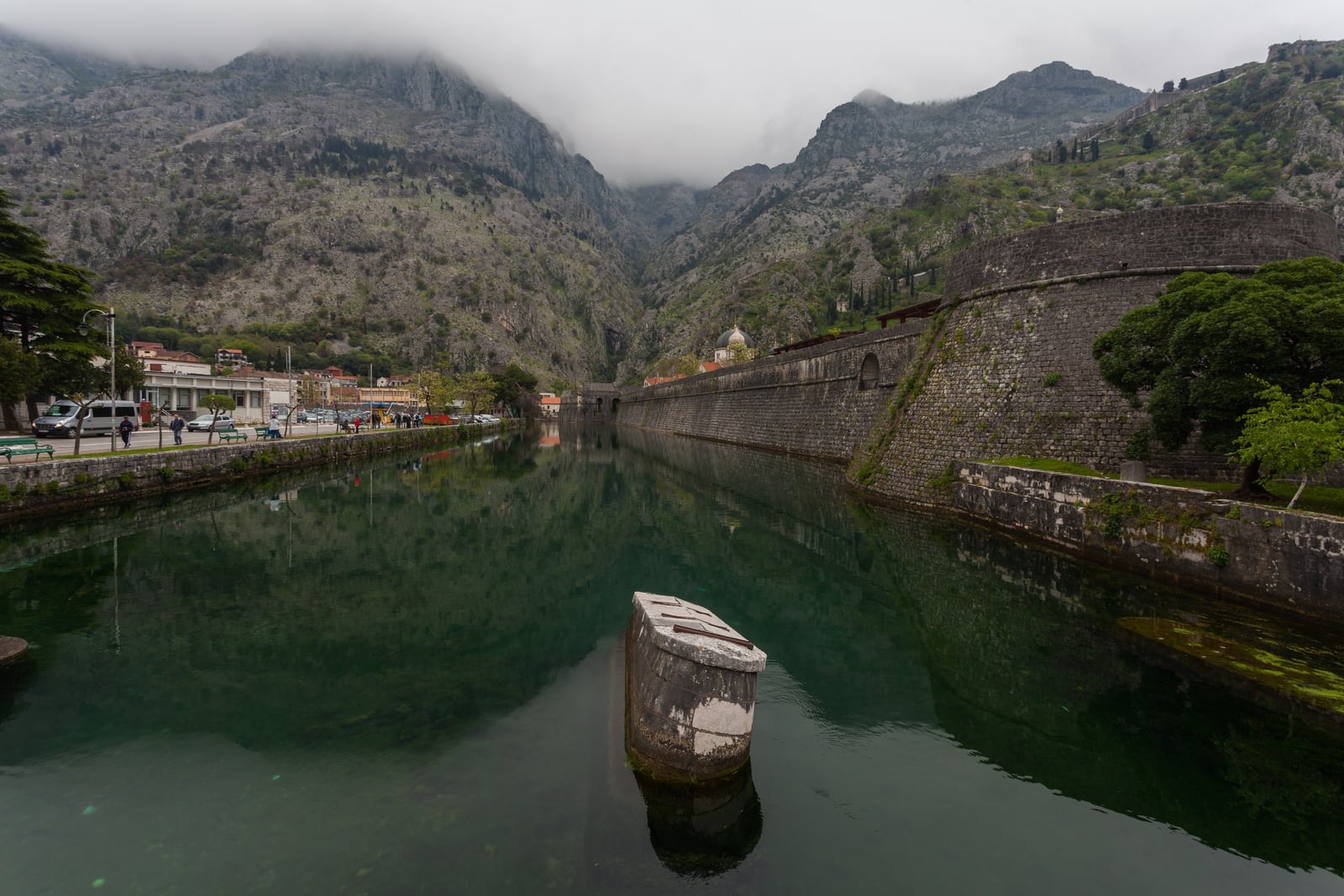
Kotor encourages the eye to escape upward. Ramparts climb the mountain, limestone presses close behind the roofs, and the fortress advertises a view that must be earned by stairs. The city's more revealing line, however, is almost level. It runs for a few minutes beside the Škurda River, from the stone bridge at the North Gate to Kampana Tower where fresh water meets the bay.
Begin beneath the North Gate, step out across its stone bridge, then turn west on the outer bank. Keep the Škurda and the northern masonry continuously on your left until Kampana rounds the corner toward the harbor. The raw distance is only a few hundred metres and takes minutes without stops. Give it 30–45 minutes.
This is a two-anchor visit: North Gate first, Kampana second. It costs €0, needs no reservation and asks for no compulsory purchase [6][7]. The paid mountain walls are a different decision. Keeping the two experiences separate is what allows Kotor's defensive logic to emerge before the city becomes a panorama.
Choose a gap in the port day
There is no honest universal “quiet hour” for Kotor. The old town sits immediately beside a cruise port, and its pedestrian rhythm changes with the ships. Port of Kotor publishes a year-specific arrivals page with downloadable schedules; check it the evening before and again that morning because calls and times can change [4]. A current local report expects roughly 580 cruise ships and more than 770,000 cruise visitors in 2026, with the busiest cadence from May through November [5].
On a summer date with no call or one small call, use 06:30–08:15. On a multiple-ship date, look for either an early interval before the first listed arrival or a second window beginning roughly 60 minutes after the final departure. Those are planning rules, not promises: disembarkation, tenders and excursions do not move like a station clock. Recent community reports agree on the mechanism even when their experiences differ—Kotor changes markedly when cruise groups reach the old town, while early wandering or staying outside the walls softens that pulse [6][8].
Let the official port sheet choose the window instead of copying somebody else's fixed hour. It is more useful than merely setting an alarm. Save River Gate (North Gate) or Vrata od Škurde, not just Kotor Old Town. A 2026 local visitor map places all the principal old-town landmarks within a 10-minute walk of the Sea Gate and identifies the North Gate as the quieter river-side exit [11]. If you arrive at the main gate, walk through the old town to North Gate and make the river your exit. That preserves Kampana for the end instead of showing the route's conclusion first.
Cross fully before turning
The North Gate can disappoint anyone hunting for Kotor's grandest portal. Current reviews call it the smallest of the three gates and sometimes the least imposing. The useful correction comes in the same review record: the stone bridge and the opposite bank reveal the wall more clearly than the arch does by itself [6].
Pause under the gate and look up. Port of Kotor's official English brochure distinguishes this entrance from the broader Sea Gate: the North Gate is smaller, has a Renaissance tympanum and contains a guardroom that watched the stone bridge. It mattered because the route beyond it led toward Budva and Cetinje [1]. The building is not simply a hole in the wall; it is an instrument for inspecting movement.
The gate dates to 1540 [1][6], but “old” should not be confused with untouched. UNESCO records that Kotor's walls and many monuments were seriously damaged by the 1979 earthquake, then restored and reconstructed with international assistance [2]. Look for changes in stone tone, joint, edge and finish without playing at instant archaeology. The visible wall is both inherited fabric and the result of conservation choices.
Now cross at walking pace. If someone is bringing a bicycle, luggage or supplies through, give them the line. The bridge is an access route before it is a composition. Reach the outer bank before stopping, then turn back for the complete gate-and-bridge view. Take the recognition photograph from the bank or from one end of the bridge, not from its narrow middle.
The Škurda is not decorative water placed beside a medieval set. It closes the northern side of Kotor's triangular ground plan, while the bay closes the southwest and Mount St John rises behind the east. A technical survey of the fortifications describes a system about 4.5 kilometres long, reaching roughly 250 metres above sea level; at this bridge, that huge vertical circuit touches an ordinary pedestrian entrance [3].
Keep water and wall on the left
From the outer end of the bridge, turn west, toward the bay. The direction is self-checking: the Škurda and the wall should remain together on your left. If either disappears, you have started a different walk.
The handoff to Kampana is roughly 300 metres by map coordinates, not an official signed distance. It takes about 4–6 minutes without stops; slow it by watching how the wall changes beside the water. The fortification is first a long plane, then a sequence of heavier projections, then the rounded mass at the river mouth.
Most of the local knowledge here is behavioral rather than secret. Walk in single file when the bank path tightens. Step fully beside a bench before checking a map. Keep voices down in the early window; residents use this edge before it becomes a visitor viewpoint. Ask before making a close portrait. Give birds on the water distance and keep food and packaging out of the river. These small choices preserve the advantage of the Škurda edge better than any claim that it is “hidden.”
Do not divert into a car park, café or hillside path merely because it appears within reach. The route needs the wall as a continuous thought. The old town can have another hour. For this one, notice the masonry becoming heavier toward the river mouth and the geometry changing from a straight defensive edge into Kampana's rounded mass.
Kampana occupies the hinge where the Škurda enters the Bay of Kotor. The technical survey identifies the main tower as the protection for the citadel at this river boundary [3]. Recent visitor photographs and reports still favor the outer bank because that angle gathers tower, water, wall and mountain without requiring an elevated ticket [7]. Let the final view reverse the first one: at North Gate the river seemed to run beside the city; at Kampana it becomes clear that river and bay were part of the city's perimeter.
Stay for 10–15 minutes, not for an indefinite photo stakeout. Make one wide frame before zooming in. If coaches or taxis are loading, do not stand in their turning space. Wet limestone and polished paving can be slick, so after rain shorten the route rather than forcing the edge for a photograph.
The ascent begins nearby, but it is not a free sequel
North Gate also points toward the hillside paths, which is why outdated travel advice can derail this compact walk. The municipality's published fee notice lists the official wall-and-fortress entry at €15 per individual visitor. It gives the seasonal hours as 07:00–20:00 from May through September, with shorter shoulder-season hours, and names one controlled entrance at Parilo behind the Church of Blessed Ozana [10]. Check the current notice locally before climbing; the price and access window belong to that separate visit, not to the free river seam.
More importantly, do not follow posts that describe entering the paid walls through an opening from the old road. In May 2026, Kotor municipality temporarily sealed irregular apertures after they had been used for organized access with improvised ladders, ropes and other aids beyond controlled safety arrangements [9]. The old road outside the walls and the ticketed fortifications are not interchangeable. A path being visible does not grant permission to breach protected masonry.
The necessary boundary is simple: decide at breakfast whether this is a level wall reading or a fortress climb. If it is the former, carry no summit ambition into the North Gate. If it is the latter, use the official entrance, current hours, water and appropriate footwear, and give it its own weather and heat assessment.
Four shortcuts that erase the river
The first shortcut is entering through the Sea Gate simply because most people do. That delivers the grand civic threshold but hides the water system behind the walls. The better opening is the opposite bank of the Škurda; use the Sea Gate later as an exit.
The second is treating “early” as sufficient preparation. Four ships at 08:00 and no ships at 08:00 create different streets. Read the official arrivals sheet, then choose the 60–75-minute gap that exists on your date [4][5].
The third is stopping in the center of the North Gate bridge for a long portrait session. Reviewers value precisely that bridge view, which means the same few metres attract both pedestrians and cameras [6]. Compose from an end, cross once, and keep the aperture usable.
The fourth is converting a free ground-level walk into an improvised free fortress entry. Old posts showing ladders or openings are now safety hazards and stale instructions, not clever local knowledge [9]. Keep the required spend at €0 for this route; spend the separately posted €15 only if you deliberately choose the controlled ascent [10].
In practical terms, arrive with the port schedule already saved, exit through North Gate, cross fully to the outer bank, turn west with the Škurda and wall on your left, and finish opposite Kampana. Allow 30–45 minutes. There is no formal queue and no reservation, only occasional compression at the bridge and gate. The entire route is non-food, so no order is required; carry water and postpone breakfast rather than turning the first open terrace into a third anchor.
Kotor's mountain walls are spectacular because they seem to defy gravity. Its river wall is more instructive because it explains the city without spectacle. On this short seam, a bridge controls entry, a current reinforces a boundary, a tower turns toward a bay, and restored stone still performs the old work of defining an inside and an outside.
Sources
- Port of Kotor, Centuries Young — official English visitor brochure on Kotor's three gates, the North Gate's Renaissance tympanum and guardroom, and its historic road connection.
- UNESCO World Heritage Centre, “Natural and Culturo-Historical Region of Kotor” — the fortified cultural landscape, 1979 earthquake damage, restoration and continuing conservation context.
- 3D-IMPACT / Polytechnic University of Bari, “Fortification system of Kotor” — architectural survey of the Škurda boundary, North Gate, Kampana, wall length and hillside extent.
- Port of Kotor, “Najava dolazaka kruzera” — official 2026 cruise-arrivals page with downloadable annual schedules; use for date-specific crowd planning.
- Boka News, “Zahuktava se kruzing sezona – danas u Kotoru četiri kruzera” (May 6, 2026) — local reporting on expected 2026 calls, visitor volume and the May–November cruise cadence.
- Tripadvisor, “Northern Gate” — current review surface, including 2025–2026 reports on the River Gate's scale, ordinary access, stone bridge and best wall-facing viewpoints.
- Tripadvisor, “Kampana Tower” — current visitor photographs and 2025–2026 reports locating the tower at the Škurda mouth and identifying the outer bridge as the useful ground-level view.
- r/montenegro, “Tourist Thread 2026” — current community discussion of Kotor access, crowd-aware pacing, buses, taxis and slow travel around the bay; treated as anecdotal field evidence.
- Municipality of Kotor, “Saopštenje povodom privremeno zazidanih otvora na kotorskim bedemima” (May 8, 2026) — official safety statement on sealed irregular wall openings, improvised access and injury risk.
- Radio Kotor, “Početak naplate naknade za kotorske bedeme” (February 28, 2025) — municipality notice on the controlled wall entrances, published fee and seasonal access hours.
- Kotor Directory, Kotor Visitor Guide 2026 — recent compact-area map, Sea Gate walking scale, North Gate orientation and fortress-path distinction.
- Wikimedia Commons, “Río Skurda, Kotor, Bahía de Kotor, Montenegro, 2014-04-19, DD 35.JPG” — source page, authorship, date, dimensions, quality-image assessment and CC BY-SA 3.0 license for the real photograph used as the cover.