Long Bien Bridge is not the place in Hanoi to go looking for quiet in the abstract. It is the place to watch a city become audible before it becomes fully visible: metal deck, motorbike lane, bicycle bell, train line, Red River haze, a market waking beneath the Old Quarter edge. The useful version is tight. Start near Hang Dau or Tran Nhat Duat before sunrise, walk onto the bridge carefully, stay out of the traffic line, look down toward the riverbank gardens, then leave before the commute turns the narrow lanes into a moving argument.[1][4][5]
As of June 8, 2026, this route is newly possible again after a repair interruption. Local press reported that Hanoi restored the original traffic organization from 0:00 on May 28, 2026, reopening the bridge to motorbikes, rudimentary vehicles, and pedestrians after urgent work on the road sections.[1] That matters more than it might seem. From March 28 to May 27, the road and pedestrian parts were suspended for emergency repairs, while traffic was diverted to Chuong Duong Bridge and rail service was handled separately.[2] Long Bien is romantic from a distance, but it is also old infrastructure. The first local move is to treat access as current information, not a permanent postcard.
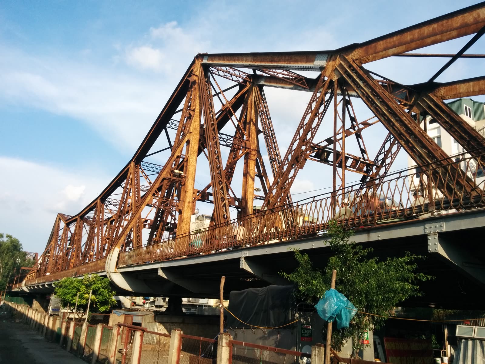
The bridge gives you a rare sideways view of Hanoi. Vietnam Airlines' travel guide places Long Bien in its French-colonial frame: built between 1899 and 1902, originally named Paul Doumer Bridge, and still organized around old railway tracks, pedestrian space, and narrow lanes for motorbikes and bicycles.[3] Nomado's current guide gives the longer structural measure often used for the full span: about 2,290 meters with 19 spans, connecting the Old Quarter side to Long Bien District across the Red River.[5] The point on the ground is not to memorize those numbers. It is to feel why a bridge that long can still feel narrow.
Go at 5:30 a.m. if weather and sleep allow. Nomado's guide puts the most rewarding sunrise window between 5:30 a.m. and 7:00 a.m., when the bridge is still mostly local commuters, delivery cyclists, workers on motorbikes, and older residents walking rather than visitors posing.[5] The same guide warns that the walkway is narrow, roughly 1.5 meters wide on each side, with motorbikes and bicycles sharing the space, so the practical rule is simple: keep to the outer edge, stop only where the bridge widens, and do not make anyone move around your photograph.[5]
That is the street microcosm. One side of the bridge is not simply "the good view." It is a decision about how much Hanoi you want to stand inside. On the quieter side, the Red River opens and the trusses repeat until the bridge starts to feel almost maritime. On the busier side, vendors and commuters make the structure legible as a corridor. You see fruit baskets, helmets, school bags, a cyclist balancing more than seems possible, and the small negotiation by which everyone makes space without stopping the city.
The second anchor is not a cafe or a monument. It is the land below. Local Vietnam pairs the bridge with Long Bien Market and notes that the market's wholesale peak is roughly 2:00-5:00 a.m., when food from the Red River Delta and northern provinces arrives before being redistributed into Hanoi.[4] You do not need to push into the market at peak hour on a first visit. In fact, most visitors should not. But knowing that the market has already been awake for hours changes the walk. At sunrise, the bridge is not the start of the city's food day. It is the moment when that food day becomes visible on the road.
The riverbank gardens make the same point in a slower key. Nomado notes informal vegetable plots under the approach spans and describes the east-bank market and gardens as part of the bridge's early-morning layer.[5] The better visitor move is restraint. Look down first. If you leave the bridge deck for the riverside, do it in daylight, dry weather, and without treating working paths or residents as scenery.
Here are the local moves that make Long Bien work:
- Check the bridge status before you go. It reopened to traffic from May 28, 2026, after a 60-day closure, but the recent repair history is exactly why old blog advice should be checked against current local reports.[1][2]
- Start from the Old Quarter edge on foot. Local Vietnam puts Long Bien Station about 900 meters from the heart of the Old Quarter and the bridge entrance about 1.5 kilometers away, while Nomado places the bridge entrance at the east end of Tran Nhat Duat Street.[4][5]
- Arrive at 5:30, leave before the crush. The most readable window is sunrise to about 7:00; after that, the commuter flow becomes the subject, not the background.[5]
- Stay on the outer edge. The narrow side lanes are shared with motorbikes and bicycles, so give the working traffic the right of way.[5]
- Do not wear headphones. The warning system here is human: engines, bells, footsteps, and the sudden tightening of the lane.
- Never step onto the rail spine for a photo. Long Bien still carries railway function, and the center track is not Train Street theater.[2][3]
- Keep the camera low-friction. Stop only where the lane widens enough that you are not forcing motorbikes or bicycles around you.
- Treat the riverbank as working space, not a hidden set. If you leave the bridge deck, avoid private homes, working gardens, and routes that feel intrusive.[5]
- Let the market context inform the walk, not hijack it. Long Bien Market is a working wholesale market with its own early, messy, high-pressure logic; after sunrise, Dong Xuan or the Old Quarter edge is a simpler reset for most visitors.[4][5]
The common visitor mistakes are all versions of the same error: making the bridge stop for you. The first is assuming the repair closure is irrelevant because someone visited years ago. It is better to treat Long Bien as a living piece of infrastructure and verify access on the day. The second mistake is standing in the narrow flow for the perfect truss photograph. You will get a better memory by taking three quick frames and moving with the bridge. The third is confusing this with Train Street and drifting toward the rail line. Long Bien's rail track is not a performance space; it is the reason the bridge remained strategically important in the first place.[2][3]
The fourth mistake is overextending. Nomado gives 30-60 minutes as the practical time needed for a crossing and return, with more time only if you linger or continue to the east bank.[5] Keep the first version to about 45-70 minutes from Old Quarter edge to bridge, pause, and return unless you have a real plan for the market or riverside. The bridge rewards attention more than itinerary.
The local-specific texture is the inherited geometry. Many visitors remember the rust, the trusses, or the Red River. What stays with you after a good walk is stranger: a Hanoi crossing that makes everyone adjust to a narrow, patched structure built for older rail and road ambitions. The bridge was built in the colonial period, damaged and repaired through war, patched into peacetime traffic, closed again in 2026 for urgent road work, then reopened because the city still needs it.[1][2][3][5] Its mismatched spans and tight circulation are not defects in the travel experience. They are the experience.
Expected spend is almost nothing if you keep the route clean: the walk itself is free, with the only likely cost a ride-hailing trip back if heat, rain, or fatigue catches you. Best time window: 5:30-6:45 a.m. in hot months, or a cautious sunset pass if you are comfortable with heavier traffic. Navigation cue: Hang Dau / Tran Nhat Duat -> Long Bien Station edge -> bridge pedestrian side -> short pause over the Red River -> return before the commute thickens. Shoes: closed, grippy, and unprecious. Weather rule: skip the bridge in heavy rain or poor visibility.
Long Bien Bridge works because it refuses to become only a view. It is a river crossing, repair story, commuter route, market balcony, and agricultural overlook in one narrow structure. Go early enough that Hanoi is still assembling itself, and leave before your presence starts to feel larger than the bridge.
Sources
- Lao Dong, "Hanoi restores traffic on Long Bien bridge from May 28" (May 26, 2026) - local press report on the May 28 reopening to motorbikes, rudimentary vehicles, and pedestrians after road-section repair.
- Viet Nam News, "Ha Noi to suspend road traffic on Long Bien Bridge for 60 days" (March 27, 2026) - closure window, diversion plan, railway note, and structural-weakness context.
- Vietnam Airlines, "Long Bien Bridge: A Timeless Witness to Hanoi's History" - travel guide covering history, access, bridge layout, sunrise/sunset timing, rush-hour caution, walking shoes, and train-track safety.
- Local Vietnam, "Long Bien Bridge & Long Bien market in Hanoi - 3 highlights" - local guide to the bridge, Long Bien Market peak hours, Long Bien Station, and walking distances from the Old Quarter.
- Nomado Travel, "Long Bien Bridge: Hanoi's Century-Old Span Over the Red River" - current visitor guide to the Old Quarter approach, 30-60 minute timing, narrow 1.5-meter walkway, sunrise window, east-bank market, riverbank gardens, and rough preservation state.
- Amenoc, "File:Long Bien bridge.jpg," Wikimedia Commons - photographic source for the article image, showing Long Bien Bridge in Hanoi.