If you only borrow one Hamburg evening habit, make it this one: do not stay on the noisy side of the harbor once the offices empty out. Start at Landungsbrücken, drop into the Alter Elbtunnel, walk the river from underneath, and come up on the Steinwerder side when the north bank has already started glowing but has not yet turned into pure nightlife blur.[1][2][4] The move is tiny, but it changes the city fast. Hamburg stops behaving like a waterfront attraction strip and starts acting like a working port with a skyline attached.
The official infrastructure logic is what makes the ritual so good. Hamburg Port Authority's current information page puts the tunnel length at 426.5 metres and states that pedestrians and cyclists can use it all day and all night free of charge. The same page notes that the glass passenger lifts are open around the clock, while the large freight lifts run 05:30-20:00 on weekdays and 10:00-18:00 on Saturdays, Sundays, and holidays.[1] Hamburg Tourism adds the missing civic scale: the tunnel opened in 1911, runs at almost 24 metres below the Elbe, and was the first river tunnel of its kind on the European continent.[2] In practice, that means the route still works after museums, after a late coffee, and after the first dinner wave has already started elsewhere.
What matters even more than the engineering is the angle of arrival. Hamburg Tourism's current viewpoints guide still recommends reaching the area by U3 or S1/S3 to Landungsbrücken and then crossing the old tunnel on foot to the other side for the skyline read.[4] A recent local thread in r/hamburg says the same thing more bluntly: the Steinwerder platform is not elevated, but the skyline is still beautiful and the walk through the tunnel is worth doing in its own right.[8] Another recent visitor thread frames the tunnel as one of the cleanest first-time Hamburg moves in good weather precisely because you cross the river from underneath and then get the city back as a single shape.[7]
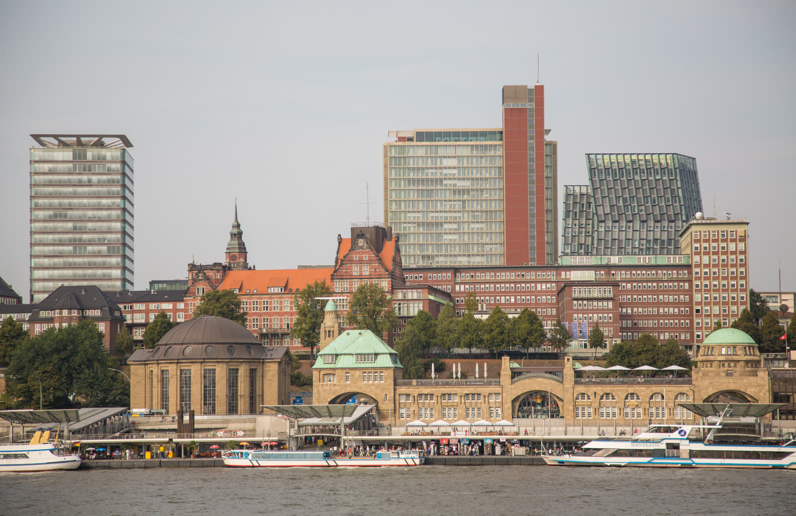
Image context: the cover uses a real documentary photograph from Wikimedia Commons showing the Hamburg skyline from Steinwerder. That is the right image for this article because the route is not about the tunnel as an isolated monument; it is about the moment the north bank snaps back into focus once you emerge on the south side.[12]
Why this ritual works better after 7 p.m.
Landungsbrücken in daylight can be useful and still feel over-explained. Ferries, ticketing, dock traffic, bridge numbers, souvenir momentum, and too many half-formed plans compete for attention. The tunnel fixes that by force. Once you are inside the tiled tube, all the surface distractions fall away. You get one task only: keep walking straight until Hamburg reappears with more distance and more order.[1][2]
That is why the article insists on the after 7 p.m. band rather than the middle of the day. By then the harbor edge still has enough ambient movement to feel alive, but the skyline has started simplifying into a legible line of piers, towers, and volume. FINK.HAMBURG includes Steinwerder in a local roundup of strong views for exactly this reason: you go through the old tunnel and look back at the Landungsbrücken side from across the water.[5] The local photography blog In Hamburg unterwegs reaches the same conclusion from a different angle, treating the tunnel as both infrastructure and a reliable photo spot.[6] The point is not that Hamburg suddenly becomes empty. The point is that the city becomes readable.
There is one current caution that locals already treat as normal operating reality: same-day work windows still happen. HPA's traffic tower remains the page to check before you leave, and a recent r/hamburg closure thread shows why; temporary tunnel closures from 21:00 to 05:00 were announced there in April 2026, with locals also warning that tourist-time crowding and wrong-lane cycling can make the tube more stressful than it needs to be.[3][9] The route still works beautifully, but it works best when you treat it like real infrastructure, not a frozen postcard.
8 local moves that make the crossing land correctly
- Start at Landungsbrücken on purpose, not at random. Hamburg Tourism's own access note via U3 or S1/S3 is the clue: you want the north-side transport knot first, because the south-side calm only registers when it follows that bustle.[4]
- Use the glass passenger lift if you want the cleanest entry. It is open 24/7, which is what makes late-evening use so friction-light for pedestrians.[1]
- Aim for roughly 19:00-21:00 in spring. That window usually gives you enough light to keep the skyline layered while avoiding the flatter midday exposure and the more scattered late-night harbor drift.[4][6][8]
- Treat the tunnel walk itself as part of the reset. At 426.5 metres, this is a real crossing, not a decorative underpass; at a normal pace it deserves its own 6-8 minutes of attention before you look up again.[1][6]
- Keep to the right the whole way. That advice surfaces in current local discussion for a reason: cyclists still use the tunnel, and the wrong side multiplies friction fast.[9]
- When you emerge, do not stop at the portal. Move outward until the skyline opens into one continuous read of piers, river, and buildings. Local community advice keeps pointing to Steinwerder's platform effect rather than to the tunnel exit itself.[5][8][11]
- Make the south-bank dwell short and deliberate, around 15-25 minutes. The route works as a hinge, not as an all-evening camp; the value is in the perspective shift, not in staying until the view turns numb.
- Check same-day operating notices if your timing is tight. Temporary night closures still happen, and HPA's traffic tower is the source that matters most when you are threading the route into a dinner or last-train plan.[3][9]
Non-local trapline
Mistake 1: treating the tunnel as a rainy-day backup
Better move: make it the main move. The official pages and the local threads agree that the crossing itself is the point, because it turns Hamburg from a crowded edge into a composed skyline read.[1][2][7][8]
Mistake 2: going at noon because the tunnel is "open all day anyway"
Better move: use the late band instead. The infrastructure is always there, but the route becomes more legible once the surface glare fades and the harbor starts simplifying into shape.[4][5][6]
Mistake 3: standing in the middle of the tunnel for photos
Better move: keep moving, keep right, and let the photographs happen on the Steinwerder side. Current local discussion makes it clear that tunnel etiquette still matters when cyclists and visitors share the same tube.[9]
Mistake 4: assuming a route this old must also be operationally static
Better move: check the same-day HPA notice page before you commit a tight evening slot. The recent April 2026 closure notices are exactly the kind of small operational detail that can break an otherwise compact run.[3][9]
Concrete go details
- Best window: 19:00-21:00 in spring, with the route still usable later if you re-check the traffic notices first.[3][4]
- Expected spend: EUR 0 for the crossing itself; if you are riding in rather than walking from the center, current HVV singles in the main 1-2 ring band are EUR 4.10, with app/shop purchases discounted by 7%.[10]
- Queue and reservation reality: no reservation layer; the only real friction is occasional lift clustering on the north side or temporary works windows announced by HPA.[1][3]
- What to do on arrival: ride or walk to Landungsbrücken, take the tunnel south, stand long enough on the Steinwerder side to read the skyline as one object, then return before your evening scatters into another harbor checklist.[4][7][8]
- Navigation cue:
Landungsbrücken -> Alter Elbtunnel -> Steinwerder skyline platform -> same tunnel back.[4][5][11] - Numeric anchors worth keeping: 426.5 metres, 1911, 24 metres, 24/7, 05:30, 20:00, 10:00, 18:00, 19:00-21:00, 6-8 minutes, 15-25 minutes.[1][2][6]
Hamburg has bigger viewpoints than this and louder ones than this. What it has in short supply are tiny evening rituals that reorder the city so quickly. One descent, one under-river walk, one low platform on the far bank: that is enough.
Sources
- Hamburg Port Authority, "Information St. Pauli Elbtunnel" (official page covering the 426.5-metre length, all-day/night pedestrian and bicycle access, and current lift operating hours).
- Hamburg Tourism, "Alter Elbtunnel - Wahrzeichen der Ingenieurbaukunst" (official tourism page covering the 1911 opening, near-24-metre depth, and continental first-tunnel framing).
- Hamburg Port Authority, "Verkehrsmeldungen / Traffic Tower" (official same-day operating and closure notice page for port infrastructure including the St. Pauli Elbtunnel).
- Hamburg Tourism, "Die besten Aussichtspunkte zum Hafengeburtstag Hamburg" (official access note recommending U3 or S1/S3 to Landungsbrücken and crossing the Alter Elbtunnel for the skyline view).
- FINK.HAMBURG, "Steinwerder Alter Elbtunnel" (local Hamburg city magazine note recommending the Steinwerder side by crossing through the old tunnel).
- In Hamburg unterwegs, "Alter Elbtunnel" (local Hamburg photography blog post from 2025-01-29 describing the tunnel as a 426.5-metre connection, a protected monument, and a strong photo spot).
- Reddit, r/hamburg, "Visiting hamburg for the first time. Taking recommendations." (local/community thread, published 2025-08, recommending the Old Elbtunnel walk for a skyline view).
- Reddit, r/hamburg, "Aussichtspunkt" (local/community thread, published 2026-03, recommending Steinwerder's skyline platform via the old tunnel).
- Reddit, r/hamburg, "Alter Elbtunnel Nachts gesperrt" (local/community thread, published 2026-04, surfacing temporary 21:00-05:00 closure windows and tunnel etiquette under crowding).
- HVV, "Single / Day Tickets" (current public transport fare page for Hamburg, including 1-2 ring single-ticket pricing and app discount notes).
- Google Maps search, "Aussichtspunkt Alter Elbtunnel Hamburg" (current place-status and community-review surface for the Steinwerder-side viewpoint; accessed 2026-04-30).
- Wikimedia Commons, "File:Hamburg Skyline from Steinwerder (15148988569).jpg" (documentary cover photograph source).