Ghent's most useful blue-hour route is smaller than the postcard makes it look. Do not start by "doing the center." Start at Korenmarkt, read the current tram situation, then walk the few minutes to St Michael's Bridge and let the Graslei/Korenlei riverfront become the whole seasonal moment.[1][2][3] In spring and early summer, when the sky still holds color after dinner, the best version lasts about 60-90 minutes: arrive before the mood lighting has fully taken over, hold the bridge through the change, then use the quays as a slow edge rather than as a restaurant strip.[1][2][6]
The reason this works is structural. St Michael's Bridge is not just a viewpoint; Visit Gent frames it as the place where the Graslei, Korenlei, Old Fish Market, Castle of the Counts, St Michael's Church, Het Pand, and Ghent's three towers line up in one glance.[2] The official evening-light guide adds the missing operating detail: Ghent's atmospheric and monument lighting gives way to functional lighting at midnight, and the Korenlei/Graslei view is one of the city's signature light-plan scenes.[1] This article is a Seasonal Moment because the payoff depends on that change of light. The city is the same at 15:00, but the route is not.
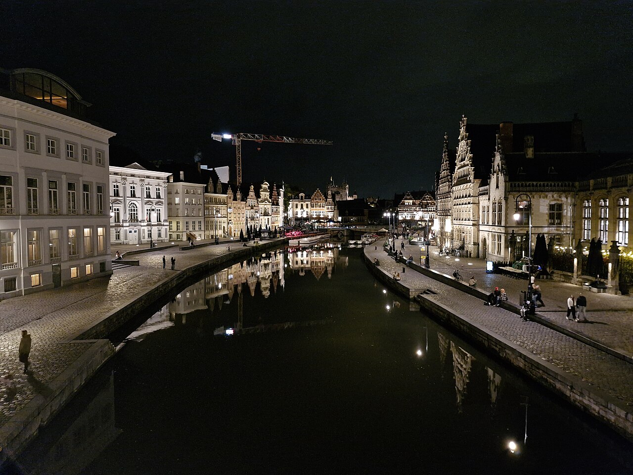
The cover image is useful because it shows the compactness: one bridge position, one river surface, one row of lit facades, and enough water reflection to make the view feel deeper than the walk actually is.[7] That is also the trap. Visitors overbuild Ghent into a checklist, then arrive at the same view tired, hungry, and late. The better local move is to keep this sequence narrow and treat food, boats, and nightlife as optional extensions, not the anchor.
Enter Through The Transit Reality
If you come from Gent-Sint-Pieters, check De Lijn before assuming the old straight tram habit still applies. De Lijn's current Ghent tram page says T1 runs via Sint-Pietersstation, Kouter, Zuid, and Moscou, while T2 includes Korenmarkt; it also notes that reconstruction on the Petercelle axis means T1 cannot run between Sint-Pietersstation and Korenmarkt.[3] Visit Gent's general public-transport page is still right about the city being tram-and-bus friendly, but the practical move in 2026 is to plan the stop, not the remembered line number.[4]
The cleanest arrival is Korenmarkt or a nearby stop between 18:45 and 20:30 in the shoulder months, adjusted to the day's sunset. If you pay contactless, Visit Gent lists a EUR 3 ride and a one-hour free transfer window on De Lijn buses and trams, with one payment method per person.[4] That matters because you can keep the route low-commitment: one ride in, one slow look, and a transfer or walk out if the weather turns. There is no ticketed attraction here, so the expected spend can stay EUR 0-6 unless you choose a drink afterward.[4][6]
From Korenmarkt, do not rush directly into the first crowd gap. Walk toward St Michael's Bridge, but pause before stepping onto the bridge deck. The local cue is the angle: if the three towers are still clear and the river surface has begun to pick up facade light, you are early enough. If the terraces have already become the loudest part of the scene, use the bridge first, then drop to the quieter quay edge rather than fighting for a front-row table.[1][2][6]
Work The Bridge Before The Quays
St Michael's Bridge earns its reputation because it solves orientation in one place. Face east and you get the three-tower line. Turn north and the Leie opens between Graslei and Korenlei. Let the Castle of the Counts sit in the distance rather than trying to go there immediately.[2] The first local move is to spend 8-12 minutes on the bridge without crossing back and forth. Pick one side, let people pass, and use the lamppost and parapet as your fixed frame.
The second move is to resist the instant photo scrum. Take the first photograph fast if you need it, then put the phone away for five minutes. The light changes in layers: facades, water, bridge stone, moving boats, then the darker gaps between buildings. Visit Gent's evening-light guide says the basic light walk is 3.2 km and 4,300 steps, but this micro-route deliberately uses only the central river slice.[1] You are not skipping the light plan; you are selecting its densest hinge.
The third move is to read the water before choosing a side. Graslei is the more obvious social edge; Korenlei often gives a cleaner look back at the historic facades. Community review surfaces treat the area as one of Ghent's high-volume visitor spots, with MapQuest/Tripadvisor showing a 4.5 rating across 2,457 reviews for Graslei and Korenlei, so the visitor density is not a surprise.[6] The way around that density is not secrecy. It is timing and edge choice.
Use The Quays Without Turning Them Into Dinner
Once you drop from the bridge, make a short loop rather than a line. Go down to one quay, walk 150-250 meters, stop where the reflection is strongest, then cross back by the bridge or the nearest comfortable crossing instead of committing to a long riverside crawl. If you want a boat, decide separately; current community-review surfaces still point to the same practical pattern around the bridge: the view is free, central, busy, and strongest when sunset or night lighting lets the water carry the facades.[5][6]
The fourth local move is to avoid using a terrace table as the viewpoint. Sit if you actually want a drink. If you mainly want the view, stay mobile and use the stone edges, bridge approaches, and brief gaps between groups. The fifth move is to leave before midnight if your goal is mood, because the official light-plan material is explicit that the atmospheric layer changes at the stroke of 12.[1] If you are still there at 23:55, stand on St Michael's Bridge and watch the switch; if you are not planning nightlife, leave earlier and keep the route as blue hour rather than late night.
The sixth move is to keep Bruges out of your head. Ghent's riverfront is not only a preserved medieval postcard. Visit Gent's Lens on Ghent material describes Graslei/Korenlei as the former main port where grain was traded, and the evening-light guide frames the river surface as part of the lighting experience.[1][8] That port memory matters because it keeps the quays from feeling like pure scenery. The facades, water, crowds, and tram access all sit on top of an old exchange edge.
8 Local Moves For This Seasonal Moment
- Check De Lijn before leaving the station. In 2026, T1 does not simply deliver the old Sint-Pietersstation-to-Korenmarkt habit; use the route planner and look for Korenmarkt or the nearest practical stop.[3][4]
- Arrive before the scene goes fully dark. In shoulder months, use 18:45-20:30 as the flexible entry band, then adjust to weather and sunset.
- Spend the first 8-12 minutes on St Michael's Bridge. It is the orientation device: three towers one way, Graslei/Korenlei the other.[2]
- Photograph once, then look. The payoff is the light changing across facades and water, not a dozen versions of the same phone frame.[1]
- Choose a quay after reading the crowd. Graslei gives social energy; Korenlei can give a cleaner reverse view.[6]
- Walk a 150-250 meter quay loop. The route should stay compact; stretching it into a full evening crawl weakens the moment.
- Keep spend optional. A contactless transit ride is EUR 3, and the view itself is free; buy a drink only if you want to sit, not because the terrace owns the view.[4]
- Treat midnight as a boundary. The atmospheric lighting yields to functional lighting at 12, so either make that switch the point or leave while the mood layer is still carrying the river.[1]
Non-local Trapline
Mistake 1: Assuming tram 1 still solves the whole arrival
Better move: plan the stop from the current De Lijn network, then let Korenmarkt be the soft entry into the riverfront. The construction note matters more than old memory.[3]
Mistake 2: Treating Graslei/Korenlei as a dinner reservation problem
Better move: separate the view from the table. Community and review surfaces confirm the area is busy and beloved; that makes it better as a moving edge than as a table hunt if your goal is the light.[5][6]
Mistake 3: Starting with the boat or the castle
Better move: hold the bridge first. Boats and the Castle of the Counts can extend the evening, but St Michael's Bridge is where the route becomes legible in one frame.[2][5]
Mistake 4: Arriving so late that the light plan has already flattened
Better move: treat blue hour as the appointment. The midnight switch is interesting once, but the strongest version is the hour when sky, facade light, and water reflection still overlap.[1][7]
Concrete Go Details
- Best window: 60-90 minutes around blue hour, usually before dinner or just after an early dinner in spring and early summer.
- Anchor: St Michael's Bridge first, then a short Graslei/Korenlei loop.[2]
- Transit cue: use De Lijn's current network and route planner; T2 reaches Korenmarkt, while T1's old direct city-center pattern is disrupted by long-running works.[3][4]
- Spend range: EUR 0 for the walk; EUR 3 per contactless De Lijn ride; EUR 3-6 if the only add-on is a simple drink or snack.[4]
- Queue/reservation reality: no reservation needed for the route; reserve only if dinner is a separate plan, because terrace demand can distract from the light.[5][6]
- Where to stand: bridge parapet first, then the less blocked quay edge; avoid stopping in narrow pedestrian pinch points.
- Recent confirmation: this route uses current official De Lijn and Visit Gent pages plus live community-review surfaces with 2025-2026 bridge and quay reviews checked for this run.[3][4][5][6]
The whole point is to let Ghent stay small for once. One stop, one bridge, one river edge, one lighting change. In a city that tempts visitors into towers, canals, castles, restaurants, boats, and day-trip comparisons, the local-feeling move is restraint: arrive correctly, stand still long enough for the light to do its work, then leave before the route becomes someone else's checklist.
Sources
- Visit Gent, "Stroll through Ghent in its most beautiful evening light" (official evening-light guide covering mood lighting, Korenlei/Graslei, midnight lighting change, and the 3.2 km / 4,300-step light walk).
- Visit Gent, "St Michael's Bridge, romantic Ghent" (official site page covering the bridge, twilight view, Graslei/Korenlei, Castle of the Counts, St Michael's Church, Het Pand, and the three-tower view).
- De Lijn, "Tram Network Ghent: Offer & construction Projects" (current 2026 Ghent tram overview, T1/T2 routing, frequency notes, and Petercelle-axis construction impact on the Sint-Pietersstation-Korenmarkt route).
- Visit Gent, "Public Transport in Ghent" (city transport guidance covering De Lijn trams and buses, Korenmarkt ticket shop, contactless EUR 3 rides, and the one-hour transfer rule).
- Wanderlog, "Saint Michael's Bridge" (community-review surface aggregating Google review score, 2025-2026 review recency, sunset/night-photo advice, free access, and bridge/quay crowd notes).
- MapQuest, "Graslei and Korenlei" (community-review surface aggregating Tripadvisor rating, review count, visitor photos, and recent review context for the quays; accessed April 22, 2026).
- Wikimedia Commons, "File:Gent - night view of Graslei 2025.jpg" (photographic image used for this article, showing the Graslei and Korenlei at night from St Michael's Bridge, photographed September 12, 2025).
- Visit Gent, "Lens on Ghent" (official augmented-reality heritage page describing Graslei/Korenlei as a former main port where grain was traded).