Montevideo is easy to over-explain and even easier to under-use. The official city page calls the Rambla one of Montevideo's defining symbols, a meeting line between the city and the Rio de la Plata, with 30 kilometers of coastal pedestrian space used for walking, fishing, exercise, and long open-air pauses.[1] The tourism portal says almost the same thing in visitor language: beaches, sports, daily local use, and a coastal strip that has become one of the city's most distinguished open spaces.[2]
That scale is exactly why a first visit should be smaller. Do not try to "do the Rambla." Use one hour at Pocitos and let the larger city stay implied. The useful two-anchor version is simple: Anchor 1 is the Montevideo sign on the Rambla de Kibon, with Playa Pocitos and the curve of apartment blocks already in view. Anchor 2 is the westward waterline along Rambla Republica del Peru, taken only as far as the light and your attention still hold. The official Pocitos page confirms the basic geography: the beach sits inside the Pocitos neighborhood, runs along the Rio de la Plata, and borders the full length of Rambla Republica del Peru.[3]
The trick is to treat this as a place portrait, not a promenade mission. Pocitos works because the public room is already doing enough: water, wind, runners, mate, benches, the sign, traffic behind you, and a horizon broad enough to slow the city down. The walk costs UYU 0, needs no reservation, and becomes better when it is allowed to stay at 45 to 70 minutes instead of being forced into a heroic coastal march.[2][3]
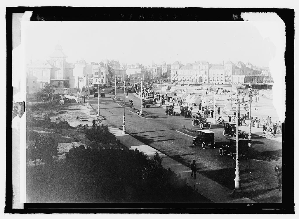
Image context: the cover uses a real archival photograph from the Library of Congress, dated between 1909 and 1920, showing Rambla de los Pocitos. It is not a decorative nostalgia image. It fits because this article is about continuity: Pocitos has long been legible as a river-facing social edge, and the modern visit still depends on reading that edge slowly.[10]
Why blue hour beats the daytime checklist
Pocitos is not hidden. That is part of the point. Montevideo's tourism page names the Montevideo sign on the Rambla de Kibon as one of the city's most visited attractions, inaugurated in 2012, and its "Descubri Montevideo" page calls the sign a key Pocitos postcard with a view over the Rio de la Plata.[2][4] If you arrive at noon, that can shrink the whole stop into the obvious photograph.
Arrive later and the same material changes. Blue hour is when the Rambla stops looking like a sightseeing strip and starts behaving like a daily civic surface. The official summer 2026 agenda is useful here because it does not sell the coast as a one-off monument. It describes beaches and coastal spaces as part of a citywide outdoor season for residents and visitors, with accessible beaches, recreation, sports, and cultural programming distributed across neighborhoods.[5] Pocitos is named in that accessible coastal network, which matters for the visitor because it confirms the place is still actively managed and used, not just preserved as scenery.[5][6]
Local/community surfaces point the same way. A recent Montevideo resident answer on Reddit describes the Rambla as a riverfront sunset place and links Pocitos, Punta Carretas, and Buceo with ordinary daytime movement and basic precautions.[8] A traveler advice thread in r/uruguay is even more blunt: once you hit the Rambla, "you could walk forever," and another commenter says walking along it is basically mandatory on a Montevideo stay.[9] The advice to take from that is not to walk forever. It is to understand why locals talk that way, then keep the visitor version disciplined.
Anchor 1: use the sign, then leave the sign
The Montevideo sign is not a mistake. It is a useful orientation device. It tells you where the route is: Kibon, Pocitos, the Rambla, river out front, city behind. Google Maps' current place surface for "Letrero Montevideo" helps with the practical part, because it pins the stop in the exact visitor language people actually use on the ground.[7]
Give it 10 to 15 minutes, not more. Take the picture if you want it, then step sideways and watch how people behave around the edge. The better Pocitos view is rarely the clean sign-only frame. It is the frame where someone is jogging through, someone is pouring hot water into mate, a bus is moving behind the line of buildings, and the Rio de la Plata refuses to look like either a river or a sea.
That is the first local move: do not block the sign or the rail for a private photo session. Treat the sign as a hinge. Let it place you, then get out of its way.
Anchor 2: walk the waterline, not the whole Rambla
The Rambla's official numbers are seductive. 30 kilometers of coastal pedestrian space; a historical coastal construction program from the early twentieth century; a linked system of beaches, green spaces, clubs, restaurants, artworks, and paths.[1][2] Those facts are important, but they are bad instructions for a first Pocitos hour.
Your route should be narrower. From the sign area, walk west along Rambla Republica del Peru with the water on your left. Hold the rail or bench line long enough to feel the wind, then stop before the outing mutates into a target list. Punta Carretas, the lighthouse, Buceo, Parque Rodo, Ciudad Vieja: all of those can be separate choices. They should not all be smuggled into this one hour.
The Pocitos page's "sin costo" listing is not just a price detail.[3] It is a design clue. The core experience is public and free. If you start building the route around dinner bookings, beach clubs, rides, or a taxi chain, you risk missing the part Montevideo already gives away.
8 local moves that make Pocitos feel less generic
- Start at the Montevideo sign only because it gives you a clean navigation cue, not because it is the whole stop.[2][4][7]
- Arrive 45 to 70 minutes before full dark. You want late light on the buildings, then softer light across the water.
- Walk with the Rio de la Plata on your left for the first westward stretch, then decide whether the route still has energy. Do not outsource that decision to a map.
- Keep the core spend at UYU 0. Pocitos Rambla is strongest as public space, and the official beach listing marks the site as free.[3]
- Bring a layer even in warm weather. The route is exposed, and the wind is part of the composition, not a bug in the plan.
- Treat mate, running groups, benches, and the rail as normal local use. Photograph around them rather than turning them into props.[8][9]
- If you plan to swim, check the current beach-status channel rather than assuming the water is the main event. The city reported active monitoring, guardavidas coverage, and a transition in water-quality communication during the 2025-2026 season.[6]
- Leave by a simple street-side reset from Pocitos or Punta Carretas instead of making yourself walk back just because the Rambla continues.[2][3]
Non-local trapline: 4 common mistakes and better alternatives
Mistake 1: trying to complete the Rambla
Better move: let the official 30-kilometer number explain the city's scale, then ignore it as a walking target. One Pocitos hour is cleaner than a tired multi-neighborhood trudge.[1][2]
Mistake 2: treating the Montevideo sign as the point
Better move: use the sign for orientation, then step away. The place becomes more Montevideo when the sign is off-center and ordinary Rambla life re-enters the frame.[2][4][7]
Mistake 3: arriving too late
Better move: arrive before the last color leaves the water. After dark, the route can still be pleasant, but the article's main read depends on seeing city, beach, rail, and river at once.[8]
Mistake 4: turning a public walk into a dining itinerary
Better move: keep food and drinks optional. The official tourism material lists the coast as one of the city's principal open spaces; if dinner becomes the anchor, the Rambla becomes a corridor instead of the room.[2][5]
Concrete go details
- Best window: the 45-to-70-minute blue-hour edge before full dark, especially when you can still read the curve of Pocitos and the river together.
- Expected spend: UYU 0 for the core route.[3]
- Queue and reservation reality: none for the walk, the sign, or the Rambla itself.[2][3][7]
- Where to stand: start beside the Montevideo sign, step off the direct photo line, then hold a rail or bench position west along Rambla Republica del Peru.[2][3][7]
- Navigation cue:
Letrero Montevideo at Kibon -> Pocitos beach edge -> west along Rambla Republica del Peru -> stop when the waterline starts feeling repetitive. - Numeric anchors worth keeping: 30 kilometers, 2012, 1909-1920, 2025-2026, 45-70 minutes, 10-15 minutes, UYU 0, 2 anchors.[1][2][3][4][6][10]
Montevideo does not need Pocitos to be spectacular in the usual way. It needs it to be available. Give the Rambla one good hour, let the sign become secondary, and the city starts to read as a long shared edge instead of a list of attractions.
Sources
- Intendencia de Montevideo, "Rambla" (official page on the Rambla as a city symbol, 30 kilometers of coastal pedestrian space, and early twentieth-century coastal construction).
- Descubri Montevideo, "Playas y rambla" (official tourism page on the nearly 30-kilometer coastal strip, daily local use, Pocitos among eastern beaches, and the Montevideo sign on Rambla de Kibon).
- Descubri Montevideo, "Playa Pocitos" (official tourism listing placing Pocitos on the Rio de la Plata and Rambla Republica del Peru, with free access and accessibility notes).
- Intendencia de Montevideo, "Descubri Montevideo" (official city page naming La Rambla and the Pocitos Montevideo sign as key visitor points).
- Intendencia de Montevideo, "Montevideo presenta una amplia agenda para disfrutar el verano 2026" (published 2025-12-29; current official confirmation of accessible coastal spaces, outdoor recreation, and tourism programming for residents and visitors).
- Intendencia de Montevideo, "Se presento el informe de gestion de playas de Montevideo" (published 2026-01-19; current official beach-monitoring and 2025-2026 water-quality communication update).
- Google Maps search, "Letrero Montevideo" (current community-review and place-status surface; accessed 2026-04-22).
- Reddit r/howislivingthere, "What's life like in Montevideo, Uruguay?" (published 2025; local/resident discussion of Rambla sunset use, Pocitos, and ordinary safety context).
- Reddit r/uruguay, "Staying in Montevideo" (published 2025; traveler/local advice thread repeatedly recommending the Rambla walk as a must-do Montevideo move).
- Wikimedia Commons, "File:Uruguay, Rambla de los Pocitos LCCN2016821769.jpg" (Library of Congress/National Photo Company Collection archival photograph used for the cover image).