At 7:00 on a Saturday morning, Kgale Hill is not empty wilderness. Shoes scrape granite, small groups separate and re-form, and the flat city begins to show through the bush below. The other hikers are not clutter in the view. For a first visit, they are part of the route.
That matters because Kgale is described in two apparently incompatible ways. A recent Botswana Tourism post calls its trails well defined and its climb about an hour [5]. Visitors writing in April and May 2026 found the path mostly clear but still reported a wrong turn or two; after rain, one family did not attempt the muddy climb at all [3]. Both accounts can be true. The route is established, but it is not a signed urban staircase. The useful local ritual is therefore not “catch sunrise at any cost.” It is to arrive when the weekend exercise crowd makes the hill easier to read.
Use one anchor and one plan: the quarry-side Kgale Hill trail on a dry Saturday. In the cooler May–September season, arrive around 07:00, allow 45–60 minutes up and 2–2.5 hours for the complete out-and-back, and aim to be down by 09:30 [1][3][6]. Go with two or three people, carry all your water, and arrange the return ride before starting. Admission is P0; set a personal P0–P50 ceiling only for water or a snack bought before arrival, not as a promised on-site price [1]. There is no booking or ticket queue. The relevant crowd is the loose stream of walkers at the trailhead.
Arrive for the people, not the sunrise
The first local move is choosing Saturday morning rather than an isolated weekday or a dramatic after-dark start. Gaborone Explorer, a current local city guide, describes Kgale as a regular workout for residents and says sunrise is a popular time, while also advising visitors to go with friends and not hike after dark [1]. Long before that guide, Mmegi described the hill as a fitness hub for greater Gaborone, used by individuals, gym groups and leisure walkers [2]. The repeated detail is not sunrise color. It is company.
Recent community evidence sharpens the point. An April 2026 reviewer began at 08:30 on a Saturday, encountered plenty of people in both directions and completed the return in just over 2 hours, while still taking several wrong turns [3]. A current review summary likewise advises hiking with friends and highlights water, unclear trail markings and ordinary baboon encounters [4]. A visible crowd does not guarantee security, wayfinding or rescue. It does make a first attempt less dependent on guesswork.
So do not arrive alone in darkness to defend a photography plan. Meet your companions somewhere unmistakable, wait for usable daylight, and begin while other groups are entering. If the trailhead is unexpectedly empty, the weather is turning, or your arranged transport has fallen through, postpone. Kgale is free; there is no sunk ticket to justify a bad start.
The second move is to make dry ground a condition, not a preference. Botswana Tourism identifies May through September as the clearer, drier hiking window. Outside those months, it advises an early start and a return before 10:00, when temperatures can rise above 30°C [6]. The May 2026 review is an equally practical warning: mud and mist were enough reason not to climb [3]. On this granite-and-rock route, “we came all this way” is not a weather assessment.
Pin the parking place, not the peak
The third move happens before the hill: navigate to the quarry-side starting area behind the Game City edge, not merely to a map label floating on the summit. The 2026 local guide supplies separate map links for parking and peak and identifies the quarry parking as the beginning of the 45–60 minute ascent [1]. Mmegi likewise locates the approach near the Kgale quarries off the Western Bypass [2]. Use the parking link in the current guide, then cross-check the live Kgale Hill Public Park place layer before departure [7].
This is the article's one navigation cue: Game City edge → quarry-side parking → visible footpath → first high point → short dip → final rise → return by the same route. It is a memory aid, not a substitute for an offline track. Botswana Tourism specifically recommends carrying GPS because hiking paths and maps can be incomplete [6]. Download the area, save the trailhead pin and start recording your route before the phone loses signal or battery.
The fourth move is to leave a clean car and a clean silhouette. Carry only water, a charged phone, sun protection and the layers you will actually use. Keep valuables out of sight and do not display a wallet or camera at the trailhead. If a driver drops you, confirm the collection point and time before the car leaves. The hill has no turnstile, concierge or dependable last-mile desk; reservation reality is simply none.
Do not treat nearby Game City as proof that the final approach is a casual mall walk. Road geometry, quarry access and the trail pin are separate problems. The better arrival is direct: a known driver or companion vehicle to the current parking point, followed by the foot route. If the live access looks different from the saved pin, ask a group beginning the climb rather than following an old photograph of a fence or painted arrow.
The first summit is not the summit
The fifth move is to let the hill reveal its two-stage shape before deciding how fast you are. In a local Mmegi account, the climb reaches a first high point, drops briefly, then rises again toward the real summit [2]. Gaborone Explorer describes the same useful bailout: at the first large boulders, before the path dips, a late or tired walker can stop for a view instead of forcing the final climb [1].
This small reversal is Kgale's best correction to visitor confidence. Gaborone is low and broadly spread, and the hill is often described as roughly 300 metres above its surroundings [1]. From below, that can look like a single blunt rise. On foot, the dip means some elevation must be surrendered and earned again. Save enough legs and water for the return instead of spending everything to win the first ridge.
The sixth move is to use the crowd as confirmation without turning it into a guide service. At an unclear fork, stop. Compare the recorded track with the direction used by several independent groups; ask where they have come from; backtrack if the answers do not align. Do not chase one fast runner onto a steeper variant. A current official post can reasonably call the routes well defined while current reviewers can reasonably miss a turn [3][5]. The right response is redundancy: offline map, remembered route, companions and live traffic.
On narrow rocky sections, step onto stable ground before letting a descending group pass. Do not cut switchbacks or build a new line around slower walkers. The weekend stream works only if each group leaves the route as legible as it found it. If you stop, move fully off the walking line rather than creating a bottleneck around a phone screen.
Give the baboons the right of way
The seventh move is to treat baboons as residents, not entertainment. Local reporting and Botswana Tourism both make their presence part of Kgale's ordinary texture [2][5]. Keep food sealed and out of sight, do not feed or approach a troop, and give animals space to cross. If the group ahead stops, stop too; do not push through for a closer photograph.
This is also why the plan does not include a summit picnic. Water is equipment. Loose food is an invitation. Have breakfast before the trail or after returning to the city, and carry out every wrapper. The on-hill spend remains P0 because there is nothing here that a successful visit requires you to buy.
Kgale's name adds a more intimate layer to the dry-season ritual. Botswana Tourism renders it as “the place that dried up” and also records two later names: the silhouette-inspired “Sleeping Giant” and “Kgalewood,” attached to the hill's use as a filming location [5]. Those names pull in different directions—water memory, bodily form, screen history—but Saturday walkers add a fourth reading without renaming anything. For a few hours, the landmark becomes Gaborone's outdoor training room.
Read the city, then leave on time
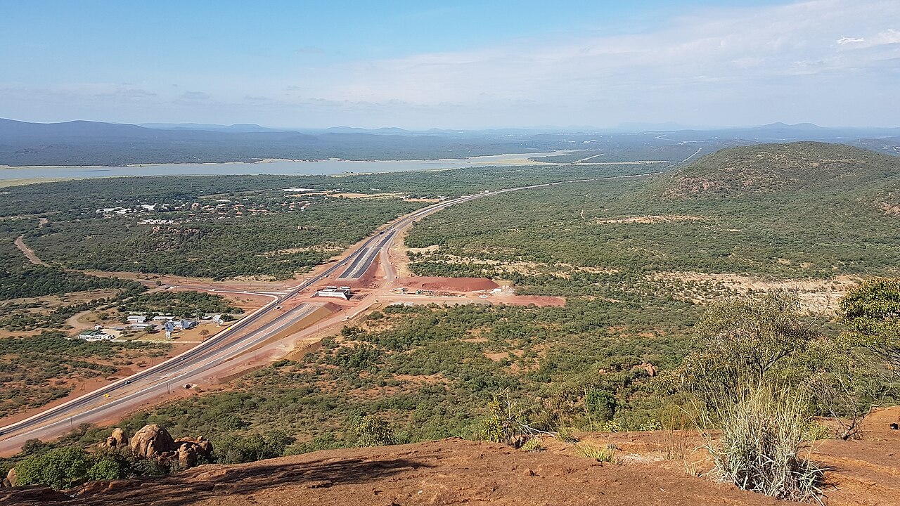
At the top, the eighth move is to stop moving long enough to understand what the climb connects. The A1 runs past the hill, Gaborone Dam lies beyond it, and the city's low spread appears on the other side. The photograph above looks south from below the summit and catches the road and water in the same frame [8]. Kgale is not an escape from Gaborone so much as an edge from which its systems become visible.
Choose a stable rock away from the main path, take water, and give the view 10–15 minutes. Do not stand in the center of the summit traffic for a sequence of portraits. The resident rhythm is closer to arrive, breathe, stretch, look and return. A summit is a turnaround point, not permission to forget the descent.
Begin down no later than 08:30–09:00 if you want the cooler plan to hold. Retrace the recorded route, slow down on loose rock, and regroup at every uncertain turn. The final local move is refusing to split the party because one person descends faster. Finish together at the same parking point and send for the pre-arranged ride only after everyone is accounted for.
Four mistakes that break the ritual
Mistake one: hiking alone before dawn to own the sunrise. Local and community sources consistently favor companions, morning traffic and no after-dark hiking [1][4]. Better: begin in usable light with two or three people and let a busy Saturday supply extra route confirmation.
Mistake two: pinning “Kgale Hill” and assuming the phone has solved the entrance. A peak pin is not a trailhead, and current reports still include wrong turns [1][3][7]. Better: save the quarry-side parking point, an offline track and your return route before leaving the city.
Mistake three: reading a mostly flat capital as evidence of an easy stroll. The climb is rocky, approximately 45–60 minutes upward, and interrupted by a dip between high points [1][2]. Better: turn around at the first boulders if time, heat, water or confidence is already running short.
Mistake four: letting schedule beat conditions. Current visitors abandoned a wet May attempt, and the official national guidance pushes hot-season hikers back before 10:00 [3][6]. Better: go only on dry ground, carry water, and make an empty trailhead or worsening sky an automatic no-go.
Kgale Hill does not need an itinerary built around it. It needs a Saturday, dry rock, companions and enough humility to turn around. Arrive at 07:00, spend P0, take the established route at the pace of the group, and leave the summit while the morning still belongs to walkers. The crowd is not a promise that nothing can go wrong. It is Gaborone's quiet way of making one rough path more readable together.
Sources
- Gaborone Explorer, “10 Things to Do in Gaborone” (published April 16 and updated May 8, 2026) — current local guidance on Kgale as a resident workout, the quarry-side parking pin, free access, the 45–60 minute climb, sunrise traffic and group practice.
- Frederick Kebadiretse, “My Kgale Hill Climbing Experience,” Mmegi (October 21, 2010) — local reporting on the hill's fitness culture, quarry-side start, rocky two-stage climb and ordinary baboon presence.
- Tripadvisor, “Kgale Hill” (2026 review page) — recent April and May 2026 visitor confirmations of Saturday traffic, a roughly two-hour return, wrong turns, rocky footing, mud and the decision not to climb in poor conditions.
- Wanderlog, “Kgale Hill Public Park” — current community-review synthesis and recent Google-review excerpts on hiking with friends, carrying water, unclear trail markings, rocky footing and baboon encounters.
- Botswana Tourism, “Kgale Hill: Elevate Your Gaborone Experience” (2026) — recent official confirmation of the one-hour climb, fitness and leisure use, baboon troops, and the “place that dried up,” “Sleeping Giant” and “Kgalewood” names.
- Botswana Tourism Organisation, “Hiking” — official seasonal guidance on the May–September dry window, early hot-season returns, water, GPS and Kgale Hill's suitability for hiking.
- Google Maps, “Kgale Hill, Gaborone” — live place layer for cross-checking the destination and approach before departure.
- Wikimedia Commons, “Kgale Hill, view south 20200329.jpg” — CNJerem's real March 29, 2020 photograph, original dimensions, scene description and CC BY 4.0 provenance.