Dublin's Docklands can look too finished if you arrive without a plan: convention glass, theatre geometry, red paving, a bridge everyone photographs from a distance, then a fast drift back toward the center. The cleaner read is tighter. Start inside Grand Canal Square, let the square teach your eye how this part of the city is staged, then walk onto the Samuel Beckett Bridge only after the light starts thinning.[1][2] At blue hour, those two anchors turn the Docklands from generic "new Dublin" into something more exact: a public room built for events and loitering that feeds directly into a working river crossing, then sends you back with a sharper view of both.
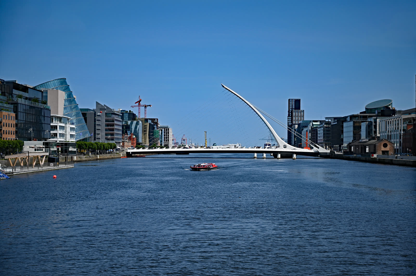
The official descriptions make that pairing unusually legible. Visit Dublin says the Samuel Beckett Bridge links Guild Street to Sir John Rogerson's Quay, stretches 120 metres long and 48 metres high, and rotates 90 degrees to let ships pass.[1] Dublin City Council gives the square the matching half of the logic: Grand Canal Square opened in June 2007, covers 10,000 square metres, and was designed to host movement, festivals, and performances through both day and night.[2] The important local reading follows from those facts. The square is not decorative spillover around a famous bridge. It is the approach system that teaches you how to use the bridge at the right scale.
Community signal makes the timing rule clearer. Lovin Dublin recommends this exact zone as one of the city's strongest design-heavy walks, crossing the Beckett Bridge and continuing through Grand Canal Dock.[4] A recent r/Dublin evening-walk thread compresses the same instinct into a simpler line: the Grand Canal is beautiful all year round.[5] Another local thread is useful for the negative version of the advice. People who cycle through Grand Canal Dock complain about crowding, confusing shared-space layouts, and awkward junctions on the approach to the "harp bridge" when the area is busy.[6] That is the real Docklands distinction. This is an excellent short city sequence when the space loosens. It gets worse, not better, when you insist on treating commuter density as part of the charm.
Image context: the cover uses a recent real photograph from Wikimedia Commons rather than a rendering, skyline montage, or night-saturated promo shot. That is the right recognition cue here because this article is about how one actual bridge behaves in the Docklands once you approach it on foot from the square, not about Dublin as an abstract skyline.[7]
Read The Square Before The Bridge
Grand Canal Square works best when you let its surfaces do the first part of the explanation. Dublin City Council describes the place as a large civic floor crossed by granite paths, a red "carpet," and a greener planted strip that can hold movement in multiple directions while still staging events.[2] That is exactly how to use it. Spend the first 8-10 minutes on the south side, near the Bord Gais Energy Theatre edge, before you climb onto the bridge. Notice how the red paving pulls the eye toward the water, how the square behaves like an outdoor foyer, and how the bridge only starts to make sense once you have seen the plaza feed people toward it.[2]
This first pause matters because the Beckett Bridge is easy to misread as a single-photo landmark. From farther west along the Liffey it is mostly an object: harp profile, cables, clean engineering, postcard value.[1] From Grand Canal Square it becomes part of a sequence. The theatre, the red paving, the dock edge, the river, and then the bridge all line up into one short Docklands sentence. If you rush onto the bridge first, you flatten the place into infrastructure. If you let the square speak first, the bridge arrives as an answer.
Use The Bridge As A Crossing, Not As A Marathon
The bridge itself rewards restraint. Visit Dublin frames it as a symbolic modern landmark, and Dublin City Council's traffic page adds the operational fact that scheduled openings can temporarily close it to pedestrians and vehicles.[1][3] That means the useful visit is not a sprawling Docklands hike built on optimism. It is a compact 35-50 minute loop built on timing discipline. Cross at a walking pace, stop once or twice, take the north-side landing view, then decide whether to turn back immediately or continue only if the area feels loose and uncrowded.
That turn-back logic is where local knowledge changes the outcome. The recent r/Dublin complaints about Grand Canal Dock and the bridge approach are not saying the area is ugly; they are saying the shared pedestrian-cycle choreography gets clumsy when traffic and footfall are high.[6] So the best version of this place portrait is not "cover more ground." It is "read the square, take the bridge at the right hour, and avoid turning a strong short route into a messy circulation problem."
8 Local Moves That Make This Portrait Work
- Start at the theatre side of Grand Canal Square. The square reads most clearly when you enter from the Bord Gais Energy Theatre end and let the red surface pull you toward the water.[2]
- Aim for blue hour, not full dark. The best window is about 20-30 minutes before sunset through roughly 45 minutes after dusk, when the square still has shape and the bridge begins to glow without losing its structural lines.[1][2]
- Walk one slow diagonal through the square before photographing anything. The point is to understand how the plaza channels movement in multiple directions, not to collect one static angle immediately.[2]
- Step onto the bridge from the south side only after you've read the square. That preserves the sequence: plaza first, crossing second.[1][2]
- Keep weekday rush hour out of the plan. Local users repeatedly complain that the Grand Canal Dock and Beckett approach becomes awkward when cyclists, pedestrians, and turning traffic all pile into the same shared spaces.[6]
- Take one north-bank look, then choose the clean return. The strongest payoff is often the backward view after a short crossing, not a dutiful continuation into every nearby Docklands block.
- Check the city page if your timing is tight. Dublin City Council publishes scheduled bridge openings, and those closures matter if you are building the visit around a narrow light window.[3]
- Keep the outing intentionally short. This works as a tight 35-50 minute place portrait; it loses force when you bolt on unrelated city-center stops immediately afterward.
Non-local Trapline
Mistake 1: walking straight onto the bridge and treating Grand Canal Square as empty forecourt
Better move: let the square do the first read. The official Docklands description makes clear that the plaza is designed as a cultural and circulation space in its own right, not a leftover apron around the bridge.[2]
Mistake 2: going at commuter-heavy times and expecting a serene promenade
Better move: use late light instead of peak movement. Local discussion around Grand Canal Dock and the Beckett approach keeps returning to crowding and awkward pedestrian-cycle interaction when the area is busy.[6]
Mistake 3: turning the route into a full north-side march by default
Better move: take the north-bank view, then return if the space feels tight. This route is strongest as a compact Docklands loop, not as an obligation to "cover" the whole regeneration zone.
Concrete Go Details
- Best time window: 20-30 minutes before sunset to 45 minutes after dusk.
- Expected spend: EUR 0 if you are just walking the square and bridge.
- Queue and reservation reality: none, but scheduled bridge openings can temporarily stop crossings.[3]
- Where to stand: first at the water-facing edge of Grand Canal Square where the red paving runs toward the dock, then midway up the south-side footpath of the bridge, then once more on the north landing for the turn-back view.
- Navigation cue:
Bord Gais Energy Theatre -> red carpet of Grand Canal Square -> Sir John Rogerson's Quay edge -> Samuel Beckett Bridge south footpath -> north landing turn-back. - Numeric anchors worth keeping: June 2007, 10,000 square metres, 11 December 2009, 120 metres, 48 metres, 90 degrees, 35-50 minutes.[1][2][3]
Dublin has more dramatic coast, older streets, and greener evening walks than this. That is not the point of this Docklands close-up. The point is that one square and one bridge can explain a whole contemporary district if you catch them at the right hour and resist the urge to overextend the route. Read the plaza first, cross the river second, and let the return view do the final work.
Sources
- Visit Dublin, "Samuel Beckett Bridge" (official tourism page covering the bridge's 120-metre length, 48-metre height, and 90-degree opening mechanism).
- Dublin City Council, "Visiting the Docklands" (official page covering Grand Canal Square's June 2007 opening, 10,000-square-metre scale, and day/night public-space design).
- Dublin City Council, "Samuel Beckett Bridge Openings" (official traffic page linking the bridge brochure and scheduled opening-time notices).
- Lovin Dublin, "Discover Dublin: A Design-Lover's Guide To Our Fair City" (local Dublin guide recommending the walk from the Samuel Beckett Bridge to Grand Canal Dock).
- Reddit
r/Dublin, "Any good recommendations for evening walks in Dublin" (community thread from March 2026 calling the Grand Canal a beautiful walk year-round). - Reddit
r/Dublin, "Is this the head wrecking-est junction in Dublin?" (community thread from June 2025 documenting crowding and awkward pedestrian-cycle movement around Grand Canal Dock and the Beckett approach). - Wikimedia Commons, "File:Dublin - Samuel Beckett Bridge.jpg" (source page for the cover photograph used in this article).