If you only want one Chicago Loop window that actually changes outcomes, run it in two layers: the Riverwalk at water level and the Pedway below street level. Keep the scope there and the city starts to feel legible.
The Riverwalk gives you the open-air rhythm: bridge steel, boat traffic, and a direct read on downtown flow. The Pedway gives you the weather-proof rhythm: fast transfers, indoor cut-throughs, and the commuter logic that tourists usually miss.
The two anchors are physically close but behaviorally different. One is wide, scenic, and exposed. The other is compressed, practical, and often half-hidden. That contrast is the point.
A local texture detail matters here: Chicago’s river district is not just pretty infrastructure. The city still runs on movable-bridge choreography tied to seasonal boat runs, with 27 bridges lifting in sequence on scheduled mornings and each lift often taking 8–12 minutes.[3] If you hit the Loop without respecting that clock, your “quick crossing” can become a stalled 20-minute detour.
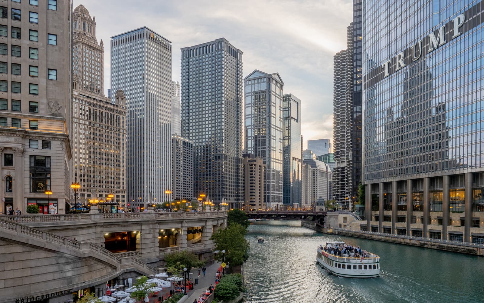
Anchor 1: Chicago Riverwalk (street-level city, water-level pace)
Start with the Riverwalk between Michigan Avenue and the Franklin/State corridor, then decide whether to push west. The city’s own Riverwalk page gives the core operating frame: a 1.25-mile continuous route, generally open 6:00 a.m. to 11:00 p.m., with four districts and multiple vertical connections back to Upper Wacker.[1]
That length is short enough to walk in one pass, but long enough to waste if you keep zig-zagging up and down stairs for photos. The better move is one uninterrupted first pass to read where crowds are pooling, then a second pass for stops.
Bridge-lift timing is the hidden force multiplier. In spring runs, CDOT posts the sequence windows and start times (typically 8:00 a.m. Saturdays and 9:00 a.m. Wednesdays in the published 2025 pattern).[3] Even outside those exact dates, that operating pattern tells you something practical: if you see bridge prep and boat staging, lock your crossing choice early rather than improvising at the river edge.
Anchor 2: Chicago Pedway (micro-navigation that saves your day)
After the Riverwalk pass, drop into the Pedway for your weather hedge and transfer efficiency. CDOT describes it as a downtown network covering roughly five miles across 40+ blocks, linking transit, offices, and civic buildings.[2]
That scale is why first-timers underestimate it. The Pedway is not one tunnel; it is a patchwork of passages, level changes, and entrances with uneven visibility. Local guides update this constantly because section access and practical wayfinding cues change over time.[5][6]
The best starting segment for visitors is the Washington/Lake/Block 37 zone because it gives clear orientation landmarks and multiple exit options without committing you to a long underground chain.[5] Once you know those connectors, you can use the network to avoid wind or rain while staying on schedule.
8 local moves that are worth more than another “top 10 things” list
First, run your day in two time bands: outdoor Riverwalk first, Pedway second. If weather flips, reverse the order and keep the same anchors.
Second, treat bridge mornings as operational windows, not sightseeing trivia. When bridge lifts are active, crossing friction can spike quickly, and “I’ll just cross at the next bridge” is often false economy.[3]
Third, on the Riverwalk, walk one full segment before stopping for photos. You will get better framing once you see where the open sightlines are around bridge trusses and river bends.
Fourth, in the Pedway, choose exit points by street objective (for example, State/Madison or Millennium-area targets), not by whichever doorway appears first. Random exits erase most of the time advantage.
Fifth, keep one fare plan before you move. Choose Chicago’s transit guide still gives useful baseline numbers: CTA rail fare is typically $2.50, bus $2.25, and the Blue Line from O’Hare is $5; airport-to-downtown times are often around 40 minutes (O’Hare via Blue Line) and 25 minutes (Midway via Orange Line).[4]
Sixth, if your route includes river crossings plus one long southbound jump, consider water-taxi timing instead of forcing everything onto sidewalks. Chicago Water Taxi currently posts public-route operations and a one-way fare of $10.00.[7]
Seventh, use the Pedway as a tactical layer, not an all-day destination. It is built for movement and climate protection; the above-ground Loop still carries most of the architectural payoff.
Eighth, keep one hard reset point: if you lose orientation underground for more than 8–10 minutes, exit to a known intersection, re-anchor, then re-enter. Fast recovery beats stubborn wandering.
Non-local trapline: 3 mistakes and the better alternative
Mistake 1: treating the Riverwalk like a static promenade
Visitors often assume crossing options are constant.
Better alternative: check bridge conditions and run your crossings early when lifts or pre-lift traffic patterns are visible.[3]
Mistake 2: entering the Pedway without an exit objective
People drop in to “explore,” then surface in the wrong place and lose the time they were trying to save.
Better alternative: choose target exit nodes before entering (for example, near a specific CTA transfer, station hall, or landmark lobby).[2][5]
Mistake 3: over-packing too many Loop sub-neighborhoods into one window
The result is stair churn and constant direction changes.
Better alternative: keep this run to two anchors only (Riverwalk + Pedway), then add extras only if your first pass finishes early.
Time window, spend range, queue reality, and one navigation cue
Best operating window for this two-anchor run is usually a 3.5–5 hour block, with Riverwalk in the brighter outdoor band and Pedway used for weather or transfer pivots.
Expected non-food spend can stay lean:
- CTA-led plan: roughly $2.25–$5.00 per ride depending on mode/airport segment[4]
- Water-taxi add-on: $10.00 one-way when in service windows[7]
- Walking core itself: free
Queue/reservation reality: neither anchor requires reservations, but friction appears at bridge crossings, station chokepoints, and occasional dock departure pulses rather than in ticket queues.
Navigation cue that works in practice: if you lose orientation near the river, re-anchor at a named bridge approach first (not a random staircase), then decide whether your next move is street-level continuity or Pedway re-entry. That one decision prevents most Loop drift.
Sources
- City of Chicago — Chicago Riverwalk (hours, length, district structure)
- City of Chicago CDOT — The Pedway (40+ blocks, ~5 miles, development context)
- City of Chicago CDOT News Release (Apr 18, 2025) — Spring bridge lifts (27 bridges, schedule pattern, 8–12 min lift window)
- Choose Chicago — Getting around Chicago (CTA fare anchors, airport timing anchors, grid references)
- Choose Chicago Blog (updated Jan 5, 2026) — Visitor guide to navigating the Pedway system
- Secret Chicago (Dec 9, 2025) — Local Pedway navigation guide and section-level context
- Chicago Water Taxi — routes/schedule and fare page (service alert + one-way fare)
- Google Maps — Chicago Riverwalk local review surface
- Google Maps — Chicago Pedway local review surface
- Wikimedia Commons image source (hero photo)