Cartagena's wall is easiest to misuse at sunset. The city seems to hand you a simple script: climb to the stones, find the famous bar, face the Caribbean, take the picture, leave. The better move is smaller and more useful. Treat the Baluarte de Santo Domingo as a wind room first and a sunset room second.
Keep the night tight. This is not a full Walled City itinerary, not a fortress checklist, and not a bar recommendation. The route has two non-food anchors: Santo Domingo's sea-facing bastion and a short stretch of wall before the old city turns fully dark. Colombia Travel describes Cartagena's historic center as surrounded by 11 kilometers of stone walls, a long defensive project completed in 1796 after almost two centuries of work.[1] That scale is exactly why the first-timer mistake is trying to "do the walls." You do not need 11 kilometers. You need one controlled edge.
Start at 17:10-17:25, about an hour before the best color. Use Plaza de Santo Domingo as the inland cue, then walk toward the wall rather than asking a taxi to deliver you straight to Cafe del Mar. Local move one: arrive from inside the city, not from the traffic edge. When you approach from the plaza, the bastion feels like a threshold between narrow streets and sea air. When you arrive at the road side first, the evening begins as a curb problem.
Local move two: walk the wall before you choose any seat. The official tourism page is right to frame the walls as a place for Caribbean sunsets, but the wall's stronger trick is the wind change: inside the lanes, Cartagena can feel still and hot; on the bastion, the air starts doing some of the navigation for you.[1] Give yourself 20-25 minutes of moving before you stop. If you sit first, the whole visit becomes table management.
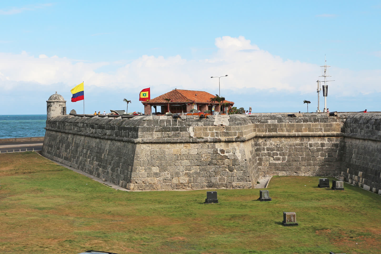
The image matters here because it shows the object before the golden-hour crowd arrives: thick stone, low grass, sea, flag, and the bastion's angular mass.[7] Santo Domingo is not just a photogenic ledge. The Instituto Cervantes cultural guide explains that the bastion was conceived around 1602 by engineers Antonelli and Cristobal de Roda, on the approach where Francis Drake had entered in 1586. It protected the access from Bocagrande and became one of the first great bastions of Cartagena's walls.[2] That is the city-specific texture to keep in mind: the sunset spot began as a hard defensive answer to a weak point in the city.
Local move three: hold the sea side without blocking the ramp. The stone paths narrow, people stop suddenly for photos, and the wall is uneven enough that phone walking is a bad bargain. Step aside before taking a picture. Keep bags closed. If someone is moving with a stroller, group, or tray, let that person pass before you reset your own frame. This is a social room, not a private balcony.
Local move four: use local review surfaces for current friction, not for ranking. The Google Maps pins for Baluarte de Santo Domingo and Las Murallas are useful before you leave because they check the exact name, walkable approach, nearby road edge, and live crowd comments better than a generic "Cartagena walls" search.[3][4] Use them to orient; do not let them expand the plan. The route is still Santo Domingo first, a short wall walk second, and then a deliberate exit.
Local move five: treat vendors with a short script. If you want water or a small purchase, negotiate before the sunset crush. If you do not, a clear "no, gracias" and continued walking works better than a long apology. The non-local error is to turn every approach into either a confrontation or a photo opportunity. People are working the wall because the wall is where the evening gathers.
Local move six: do not make Cafe del Mar the anchor unless you truly want a bar. It sits on the bastion and is an obvious landmark, but the public wall is the point of this route. Expected spend can be COP 0 if you only walk. If you buy drinks, you have changed the outing into a seat-and-service plan, which is fine, but it should be a choice rather than the default. A wall visit works best when the first decision is where to stand, not where to order.
Local move seven: stop once, not five times. After Santo Domingo, walk a compact stretch along the sea wall toward the next curve, then stop where the old city still sits behind you and the water is open enough in front. The walking tour surface on GuruWalk is useful as a recent community signal because its Cartagena route and verified 2026 reviews confirm the same basic reality: visitors still use the historic center on foot, with local guides, in relatively short loops rather than all-day wall marches.[5] Borrow that discipline. The wall should edit the city, not sprawl it.
Local move eight: leave before the wall becomes only nightlife. A June 2026 first-time itinerary from Rebecca and the World still puts Cartagena's core walking, plazas, street life, and heat management at the center of the visit.[6] That recent outside check matches the local logic here: the best first evening is not late. Aim for 60-75 minutes total. Start around 17:15, walk for 25-35 minutes, take one proper pause, then descend while the lanes still feel navigable.
The trapline is predictable. Mistake one is arriving at noon because the walls are "free." Better: save this for the 17:10-18:40 window, when heat, light, and wind finally cooperate.[1][6] Mistake two is making the bar the destination. Better: walk first, then decide whether a paid seat is worth replacing the public wall; the map and guide surfaces are more useful here as friction checks than as permission to turn the bastion into a reservation problem.[3][5] Mistake three is chasing the perfect empty photo. Better: frame around movement, stone, flag, sea, and ordinary evening traffic instead of waiting for the city to clear.[3][4] Mistake four is trying to cover the full 11-kilometer fortification because the phrase sounds manageable. Better: make Santo Domingo and one short wall segment enough.[1][3][4][5]
Concrete go details: best window 17:10-18:40; expected spend COP 0 before any drink or taxi; no reservation needed for the public wall; start from Plaza de Santo Domingo or the nearby Santo Domingo church side; walk up to Baluarte de Santo Domingo, move before sitting, stand on the sea-facing side rather than on the ramp, keep valuables boring, carry water before the ramp, and descend before you are tired. Navigation cue: Plaza de Santo Domingo -> Baluarte de Santo Domingo -> short sea-wall walk -> one sunset pause -> descend back into the Walled City by a familiar street.
Cartagena's wall is famous because it photographs well. It is better because it changes the city's pressure. One step up from the lanes, the heat loosens, the road noise drops, the sea becomes the map, and the old fortification stops being a heritage label. For one short evening, it becomes the simplest local machine in the city: a stone edge that teaches you when to slow down, when to move, and when to leave.
Sources
- Colombia Travel, "The Walls of Cartagena" - official tourism page used for the 11-kilometer wall length, defensive purpose, 1796 completion marker, and Caribbean sunset framing.
- Centro Virtual Cervantes, "Cartagena de Indias. 9. Baluarte de Santo Domingo" - cultural reference for the bastion's 1602 conception, Drake's 1586 entry, Bocagrande access, later reforms, and Santo Domingo naming context.
- Google Maps, "Baluarte de Santo Domingo Cartagena" - current map and local-review surface used for exact pin naming, approach checks, and crowd/friction signals.
- Google Maps, "Las Murallas Cartagena Colombia" - current map and local-review surface used for wall-walk orientation, route scale, and navigation checks.
- GuruWalk, "Discover the Magic of the Fantastic City of Colombia" - local-guide/community surface with 2026 verified reviews, used for the short walking-loop and guided-foot-traffic reality of Cartagena's historic center.
- Rebecca and the World, "3 Days in Cartagena Itinerary: Plan Your First Trip to This Colourful Colombian City" (published June 2026, modified June 2026) - recent visitor-facing confirmation of Cartagena walking-tour, heat, and first-timer route context.
- Wikimedia Commons, "File:Baluarte de Santo Domingo, Cartagena 01.jpg" - real photographic source for the article image, showing the Santo Domingo bastion, wall mass, sea, and Colombian flag.